I received an interesting email from a fellow post-tribulationist, Scott McPherson, who suggested that the Abomination could occur on the northern end of the Temple site due to Isaiah 14:13. This verse (below) may not be referring to Satan, as most believe, but, like the rest of the text around it, it may concern the anti-Christ -- the "king of Babylon." It's difficult to know whether or not the text alternates from the anti-Christ to Satan, but see here what one of them speaks in his heart:
"I will go up to the heavens; above the stars of God I will raise my throne. And I will sit on the mount of meeting, in the sides of the north...I will be likened to the Most High God" (Isa. 14:13).Scott views the "mount of meeting" as the end-time Jewish sanctuary. And because we see the subject desiring not only to "sit" in that place, but to become like God, Scott came to the conclusion that the apostle Paul was speaking on this very verse when discussing the anti-Christ sitting in the Temple and proclaiming himself to be (a) God.
Scott is unsure of whether or not there will be an operational Temple in the tribulation period. Personally, I don't think there will be, even in the face of Paul's flat statement to the contrary. I think that Paul had imagined a Temple building when reading "sanctuary" in Daniel, and perhaps also when reading "mount of meeting" in Isaiah. And I think that the Holy Spirit led him to use the Greek word for "Temple" that does not necessarily refer to a building, but that the alternative word for Temple, which refers specifically to a building, was wrongly slipped into copies of the Thessalonian epistle after Paul's death, not insidiously, but because everyone who copied the epistle would have likewise imagined a building...having no idea that the modern situation would transpire, with a secular Israeli government, an Arab East Jerusalem, and a Muslim shrine on the Temple Mount.
Scott's intriguing theory is that the anti-Christ could place the Abomination on a northern section of the end-time sanctuary, instead of the Western-Wall sanctuary. He also pointed out a line from Psalm 48:2, "...beautiful...is Mount Zion, on the sides of the north," that not only serves indirectly to equate the "mount of meeting" with Jerusalem, but also reveals the land on the north side of the city as being prime in the sight of God. And we can suspect that Satan/Anti-Christ, by reading Scripture, came to know that the northern sides would be prime, explaining his desires to have them as his own seat of power.
I was amazed with Scott's theory because it had never dawned on me, the reason being that the NIV Bible which I had been using does not use "sides of the north," but instead uses, "utmost heights," a very bad translation indeed. In fact, the NIV is so bad at times that I try to check with my interlinear as often as is important. Everyone should have an interlinear. All scripture quotes presented in this book are interlinear derivations.
I don't think that anyone has any particular argument against the equating of the Mount of Meeting with Jerusalem. The same Hebrew word for "meeting" is used in Isaiah 33:20: "Behold, Zion, the city of our appointed meetings" (Isaiah 33:20). But it's not the city as a whole that acts as the meeting place, but the Temple site. And because the northern sides of Jerusalem are raised above all other sides in Psalm 48, one could get the distinct impression that the Temple Mount will be on the northern side of Jerusalem. Yet the current Temple Mount is on the east and south of the City.
But not in the future! In Ezekiel 48, the Millennial City's northern reaches are exposed as prime land. Yes, and while some just won't accept it, the Millennial Sanctuary and Meeting Place will be a few miles north of the Millennial City! That is, the Ezekiel Temple won't be "downtown," which makes much sense when one thinks about it.
The Temple building will be in prime land reserved for the Zadokite priests -- land that's about eight miles long east-to-west, and three miles north-to-south (25,000 x 10,000 cubits). This northern section is called by these titles: "the holy of the land" (45:4); "the holy high offering (48:10), and at times more simply, "the high offering." The entire Square of 25,000 cubits x 25,000 cubits is also called the "high offering" (48:8). The Zadokite allotment is to be located in the midst of this Square. (By the way, I am assuming that the measurements are in cubits, but the Hebrew text does not mention which particular units when it comes to this parcel of land. The King James Version assumed in two places (45:1 and 48:8) that the Square is to be measured in reeds).
How interesting is it that Arafat is trying to take this very region, and more, as his own seat of power in the so-called "land-for-peace deal"? But don't suppose that Arafat is the anti-Christ as a result. He's much too old...by 2010, he won't be in power anymore. If George Bush convinces the Israelis to give these northern sides to the Palestinians in the so-called "roadmap to peace," do you think that God will approve?
The Temple is said to be in the "midst" of the Zadokite allotment, but there is a question as to whether this "midst" refers to 1) the very core of the Allotment; 2) centralized east-to-west upon the northern border; or 3) centralized east-to-west upon the southern border. But in all three cases, the Temple will be north of the Millennial City by some distance because the City is to the south of the Zadokite Allotment (48:15). Unless we can discover which is true, either 1), 2), or 3), we can't determine the distance from City to Temple. The maximum distance to the Millennial Temple from the north edge of the City, 10,000 cubits, would be due to 2). That distance is equal to 3.3 miles. If 1) is true, then the Temple would be just half that distance, or about 1.65 miles, from the north edge of the City. And if 3) is true, then the Temple would be adjacent to the north edge of the City. But in no case would the Millennial Temple be situated on the present Temple Mount because that Mount is south of where the northern edge of the Millennial City will be situated. That the Millennial City will be located where the Old City is now can be proven by Zechariah 14:10, where the Millennial City is associated with three gates of Old-Testament Jerusalem as well as its tower of Hananeel.
It seems, therefore, that "sides of the north," referring to the northern reaches of the Millennial City, refers specifically to the Zadokite Allotment, which makes absolute sense in that the Temple will be somewhere within that Allotment.
I should say that, in 2002, when I first wrote this chapter, I was of the impression that the Zadokite Allotment was at the very north of the Square, wherefore I had suspected the Millennial Temple to be anywhere between 3.3 and 6.6 miles north of the Old City. But now, in 2004, after a second study of the matter, I see that the Zadokite Allotment will be central within the Square, sandwiched between the Levite Allotment at the north and the City Allotment at the south. For, 48:18 tells us that the City Allotment will run alongside the Zadokite Allotment, in that this allotment is in that text called the "High Holy Offering," a phrase that specifically implies the Zadokite Allotment. And that's why I now seek the Temple Hill at a maximum of 3.3 miles north of the present Old City.
For those who want to get into this, let me explain further. The 6.6-mile stretch of land is from the northern edge of the Millennial City to the northern border of the Square. That Square consists on its southern flank of a 25,000 x 5,000 cubit allotment designated for the City (the City itself is only 5,000 x 5,000 cubits). To the north of the 25,000 x 5,000 City Allotment is the 25,000 x 10,000 Zadokite Allotment, and to the north of the Zadokite Allotment is the Levite Allotment, also 25,000 x 10,000 cubits. Thus, the whole is 25,000 x 25,000. The 5,000 x 5,000 City, at the Square's extreme southern boundary, is centralized between the east-to-west 25,000-cubit span (Ezekiel 48:15). Therefore, and this is important, if we draw a north-south line running down the middle of the Square, it will also run through the middle of the City. The Temple, within the Zadokite Allotment, should also be on this central north-south line, because it is said to be in the midst of the Zadokite Allotment.
Note from Isaiah 10 that the anti-Christ will stop at ancient Nob (in/near modern Shufat) and shake his fist at the Temple Mount from there. Nob was/is in the Zadokite Allotment, some two to three miles north of the present Temple Mount! This does suggest that the anti-Christ will come to sit in the sides of the north, perhaps meaning that he will set up his military headquarters there...perhaps with a will to stay i.e. to make the present Jerusalem his capital from where he can act as God permanently!
Is the Abomination of Desolation the setting up of an anti-Christ headquarters/government in or around Nob...instead of the trampling of the present Temple Mount? Is Nob where he plans and carries out a revolt leading to the desolation of the Old City (this is a very compelling view)? Are the "sides of the north" equivalent to Daniel's "edge" (9:27) upon which the Abomination is to be placed (note that the Hebrew word for "sides" is not the same Hebrew word as "Daniel's "edge"). Alas, Daniel's "edge" seems very much to be referring to the present Temple Mount and not to the north of the Old City. How so? For one, in the three places where the Abomination is referred to (9:27, 11:31, 12:11), it is always accompanied by the abolishment of regular offerings. It is hard to conceive of these offerings taking place somewhere north of the City, in what is now Arab East-Jerusalem. Moreover, in Daniel 8:11, where we see a fourth instance of abolished offerings, "abomination" is a missing term. Yet the text substitutes with, "...and the place of His sanctuary was cast down." This is some very strong indication that the Abomination can be defined as the trampling of the sanctuary...wherefore Daniel's "edge" (9:27) would not refer to an area outside of the present sanctuary.
On the other hand, it is possible that the Jews will succeed in building a new Temple, or at least start its construction, to the north of the present City. The Abomination could then occur in the "sides of the north." But I do not believe that God will allow the Ezekiel Temple...a 1,000-year Memorial to the Cross of Jesus Christ...to be profaned and destroyed by the anti-Christ. Thus, I do not tend to believe that the Temple will be built in the great-tribulation period. Then again, what the Jews on this side of Armageddon attempt to build as the Ezekiel Temple is not necessarily going to be the ultimate Millennial Temple.
If the hills north of Jerusalem all look a little less glorious than the Tropics now, remember that God has promised abundant Millennial rainfall on certain parts of the country...this holy part definitely being one of them. Ezekiel himself (33:28 in conjunction with 36:35) informs us that the Judean hills will become transformed from desolation to the Garden of Eden (whereas deserts will yet remain in other places of the nation).
The rains will be so abundant that a source of underground water below the Ezekiel Temple will reach the Dead Sea with the result of freshening up its salt water around the mouth of the river. Dead-Sea water level has decreased for millennia because the rate of water leaving through evaporation is greater than the rainwater washing/seeping into it, for which reason the sea has become saltier with every passing century, saltier than any other sea on earth. You could imagine that immediately after the Great Flood (of Noah), the Dead sea was about 10 times more voluminous, having a northern shore at the Jezreel Valley.
Zechariah 14:10 supports Ezekiel, and is more specific, telling us that the land from "Geba to Rimmon, south of Jerusalem," will be desolated in the tribulation period...i.e. made like the "Arabah"...but will then be raised up afterwards (not raised physically, but in the sense of sanctified), suggesting that the northern hill country northward from Jerusalem all the way to Geba (modern Al-Jaba) will be blessed. While the northern border of the Square will be 6.6 miles north of Jerusalem, Geba happens to be 6 miles north of Jerusalem. Thus, Zechariah is telling us that the "sides of the north" will bloom in their entirety, even all the way to Rimmon, south of Old Jerusalem (we don't know where Rimon was). See modern Map 1 of East Jerusalem..
The outer wall surrounding the Ezekiel Temple is entered by my Hebrew interlinear, not to mention the Septuagint, to be 500 "reeds" square (42:20), where one reed is said to be six royal cubits long (Ezekiel 40:5). The Hebrew text doesn't give the units, whether cubits or reeds, and the NIV uses 500 "cubits" instead. Although I at first thought this to be incorrect because I had read 45:2 to mean that the Temple would be 500 cubits square, I later found that the Temple would be just 100 cubits square (41:13), meaning that 45:2 speaks on a 500-cubit square wall surrounding the Temple. I apologize to all readers who were confounded or misled by that mistake. I think I now have it right. While the Temple area has only three gates in it's walls (a north, south and east gate -- no west gate), there must be another set of Temple walls simply because we see four walls with 12 gates, three on each wall (48:31). The outer set is found in 48:33, each wall being 4500 cubits long...significantly larger than a one-mile square, and amounting to 2.2 square miles.
The present Old City of Jerusalem is only 1/3 of a square mile (its Temple Mount is yet smaller, about 1/15 of a square mile) so that the as-is City could not house the outer Millennial Temple wall. Moreover, the Millennial City is to be 4,500 cubits square (48:16) so that the Temple cannot be located within it...since the Temple walls are themselves 4,500 cubits square. I do not think that we can equate these two sets of walls so that the City and the Temple area are one and the same area. I say the Temple must be located significantly north of the Millenial City, for reasons that follow.
THE LAY OF THE TEMPLE LAND
Certainly, if God is giving the dimensions of the Temple, we are not surprised to find that He is revealing its location. Possibly having the purpose of revealing that the Temple will not be the location of the present Temple site, God brings Ezekiel on a wading exercise. After 1,000 cubits, the river is only ankle deep; after 2,000 cubits it's only knee deep; after 3,000 (= about a mile) it's still only thigh deep. Then, at or just before 4,000 cubits, it turns into a deep and torrential flow that cannot be crossed. What this insight does is to tell of the lay of the Temple land. We already know from the prophet that the Temple will be built on a hill:
"On top of the mountain is all the [Temple's] border, round and round, being most holy. Behold, this is the law of the Temple" (43:12).The one-mile square wall surrounding the Temple is either 1) surrounding the peak alone (i.e. but not the rest of the hill), herein a Temple is situated at the peak, or 2) there's a Temple on one slope of the mountain with a wall at the hill's base surrounding the entire mountain. In the latter case, the text should read, "upon the hill round and round" instead of "on top of the hill round and round." See the difference? "Upon" allows the wall to be anywhere on the hill, not necessarily at the top.
My view is that, while the River is shallow at first, it's also fast-running, simply because the river runs down the hill upon which the Temple is built. Rivers on hills are never deep (unless they enter a bottleneck). Keep in mind that the quantity coming from the underground-water source must be sufficient to create a deep and torrential flow not far downstream...just 4,000 cubits away. As the river becomes knee deep after 2/3 of a mile, it apparently starts to level out by this point, meaning that the river has passed the base of the hill. The water can't be knee deep while running down a steepish hill, or Ezekiel would have fallen in. I therefore place the base of the hill between 1/3 and 2/3 of a mile from the Temple, so that the knee-deep section is on level land beyond the base. As Ezekiel is able to wade in at thigh deep a third of a mile further downstream, it is quite assured that the river current eases up significantly along this stretch, meaning that the land becomes almost level. There must be a high spot at the end of the thigh-deep area, keeping the water from becoming more shallow. In other words, the thigh-deep area is a basin.
Within a thousand cubits downstream from where the prophet is thigh deep, the river must go over the high spot and enter a ditch and bottle-neck situation in order for the water to flow deep on the one hand, and fast enough on the other to make it impossible for a man to walk or swim across. Here is Ezekiel's report at the 4,000-cubit point: "...a torrent that I was not able to pass, for the water had risen, water to swim in, a torrent that could not be passed" (47:5). Then the Lord says to Ezekiel, "Have you seen, son of man?", as if to say, perhaps, "Have you seen these clues revealing the identity of the hill upon which to build"? Yet God had given other clues:
"Behold, water came out eastward from under the threshold of the temple. For the face of the house is east, and the water came down...south of the altar" (47:1).The Millennial Temple will face east and will therefore be built on the eastern slope of the mountain, for it wouldn't make a lot of sense to locate an east-facing Temple on the western slope so that it faces uphill toward the peak. Nor would one face a Temple east if the Temple is situated on the northern or southern slope. Possibly, the Temple could be on the south-east or north-east, however.
WHERE IS THE MILLENNIAL TEMPLE?
What strikes me is that Ezekiel does not give the positioning of the Temple, except to say in 45:3 that it's in the 25,000 x 10,000 cubit Zadokite Allotment. I'm assuming that it will be centered in the Allotment, at the 12,500-cubit point. I'm also assuming that the Temple will not be midway between the 10,000-cubit width, but rather that the Temple's north wall will be on the northern border of the Zadokite Allotment, touching the southern border of the Levite Allotment. I had once written in this chapter that the Temple was in the very center of the 3,000-cubit-square wall surrounding the Temple, but this was my personal assumption rather than textual fact. I now allow the Temple to be at any location within the 3,000-cubic square.
The holy Spring, from which the River originates, will be on the north-to-south center line of the Temple. From the north wall of the Millennial City, the maximum distance to the Temple will be 3.3 miles, otherwise it will be beyond the Zadolite Allotment and into the Levite Allotment. We don't have many choices when seeking to discover the Hill. It shouldn't be very difficult for someone in Jerusalem with a good head on his shoulders, but whether God will allow that Hill to be built upon on this side of Armageddon is another story. There is some talk about building the Temple, now, to the north of the present Temple Mount. Use Modern Map 1, and Modern Map 2 to follow along.
There is a question as to whether waters from Ar-Ram hill run east to the Dead Sea or west to the Mediterranean, or both, for the hill is very close to the Divide as far as I can make out on topographical maps. A riding upon the very top of the Divide is a condition absolutely required of the Temple Hill:
And it shall be in that day, living waters shall go out from Jerusalem, half of them toward the eastern sea, and half of them toward the western sea, in summer and winter it shall be. And YHWH shall be king over all of the earth in that day..." (Zechariah 14:8-9)Most rivers in this Jerusalem region, including the Brook Kidron, flow only when the major rains come. But as the Lord will in the Millennium bring "the former and the latter rains," the water tables in the ground will rise so that springs may flow continually, "in summer and in winter." Of course, the spring waters cannot originate to the west or east of the Millennial Temple, where the land is lower, but will come from the north or south, wherever the land is higher (I don't have land-elevation information outside of Jerusalem).
The present Temple Mount atop the steep Kidron Valley does not match the Biblical picture very well. Even if underground waters should somehow be made to flow from the Temple Mount in the Millennium, they can only head south via the Kidron Valley and finally east to the Dead sea, but in no way west to the Mediterranean. See topographic map of Kidron/Himmon valleys (the solid black line is the Old City wall). I do not know for certain whether the two Zechariah rivers include Ezekiel's eastward Temple river, but it certainly sounds like it in the phrase, "living waters."
The land south of the Tel el-Ful hill (on Modern Map 2) is strongly implied by Ezekiel as being the Temple location, not just because Tel El-Ful is three miles north of Old Jerusalem, but because waters may flow to the Dead Sea via the Wadi al Ghazal as well as west to the Mediterranean via the Nahal Soreq. See also this topographic map of the Hill Country where Tel el-Ful is marked, "Gabath Saulis." If that link is inactive, see this smaller version of the map.
As the bird flies, the north wall of the present Old Jerusalem is 3,930 feet long; the west wall 2,086 feet; the south wall 3245 feet; and the east wall 2,754 feet. The 5,000-cubit Millennial Jerusalem, when converted into feet, is roughly 8,750 feet square, or a 1.66-mile square (area is 2.75 square miles), almost ten times larger in area than Old Jerusalem (.3 square miles). Therefore, the boundaries of Millennial Jerusalem will be situated significantly beyond the present walls of Old Jerusalem. Biblical indication of this is in Jeremiah 31, where it speaks of that Millennial City:
"And the whole of the valley of dead bodies, and the ashes, and all the fields to brook Kidron, to the east of the Horse-Gate corner, will be holy to YHWH" (v 40).The valley of dead bodies and ashes is the Valley of Hinnom...the Old-Testament garbage dump and grave site. As for the Horse Gate, it was near the south-eastern corner of the present Temple site overlooking the Kidron Valley. But do note that the Jeremiah quote gives us a very valuable piece of information, that the Millennial City will have the Brook Kidron as its eastern border.
Of the north and south borders of the Millennial City, Zechariah says: "from the Tower of Hananeel to the king's winepresses" (14:10). Jeremiah 31:38 also indicates the Tower of Hananeel as a border of Millennial Jerusalem, a tower said by modern scholars to have been on the north wall of the ancient City. I agree, since the wall-repairing account of Nehemiah starts at the Sheep Gate on the north-east and works counter-clockwise along the northern wall. The good news is that the north wall of the ancient City was equivalent to the north wall of the present Temple Mount (to be distinguished from the present north wall of the Old City).
It appears, then, that God through the prophets is informing us that the Millennial City will have the northern wall of the present Temple Mount as it's northern boundary, and the "king's winepresses" as the southern boundary. For my conclusions on the ancient walls, see Gates.
Most archaeologists locate the king's winepresses near the King's Gardens, the latter being at the junction of the Hinnom and Kidron valleys 2950 feet (source, Britannica) south of the south-east corner of the Old City. However, the distance from the Tower of Hananeel to the junction of these valleys is not 1.65 miles (i.e. the width of the Millennial City), but only about half that distance, or 4,450 feet (just under a mile). And so the region of the king's vineyards should perhaps include a stretch of about .75 of a mile southward of the Hinnom-Kidron junction. Jeremiah's "field's of the brook Kidron" (31:40) could be indicating this southern extremity.
If it's true that the Millennial City will have the Brook Kidron as the east boundary, the western boundary, 1.66 miles away, will be virtually where the Knesset (Israeli Parliament building) now stands. The Millennial north-south center line is thereby discovered, being just half of 1.66 miles, or about 4,400 feet westward of the eastern boundary. That gets us almost to the King David Hotel beyond the upper elevations of the Hinnon Valley. Therefore, it appears that half of the Millennial City will be, as never before, west of the Hinnon Valley, and reaching Mount Gareb, for Jeremiah said, "...the city will be built to YHWH, from Tower of Hananeel to the Corner Gate, and the measuring line will yet go neged [the Corner Gate] to the hill Gareb, and turn toward Goath" (31:38-39).
The key here is the Hebrew word "neged" (#5048) defined in Strong's as "a front i.e. part opposite." It sounds as though a straight line westward, following along the north wall from the Tower of Hananeel to the Corner Gate, must continue straight west (without turning at the Corner Gate) and beyond the Corner gate to Mount Gareb...before the north wall turns south (to Goath). Therefore, this my view locates Gareb west of the (north-west) Corner Gate. The alternative view is that "neged" requires a different direction beginning at the Corner gate, so that Gareb is either to its north or south. As it's quite apparent that we are following the north Millenial wall to begin with, we can rule out a northward turn to Gareb. That leaves only a southward turn as an option, which would then identify mount Gareb as the south-western corner of the Millenial city. If this does not fit the geography, then mount Gareb must be due west of the Corner Gate.
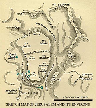
See Gareb marked on this map of Jerusalem's seven hills. It's been located to the north of the Corner Gate (gate not shown but is between what is marked Zion and Acra). I tend to think that this map is incorrect because I do not see (from the Jermeiah quote above) how Gareb can be to the north of the Old City. I cannot find any online article locating Gareb while giving a reason that is outside the scope of Jeremiah's statement. Moreover, I have found articles flatly stating that no one knows where the hill was located. The following quote from this Adobe publication (page 198) shows how the error is made that locates Gareb to the north of the old northern wall.
"The first of these two verses [Jeremiah 31:38-39, same as quoted above], as we have already seen, marked the northern enclosue of the old city; and we must evidently seek the hills of Gareb and Goath, outside the old enclosure, and over against it; consequently to the north if it."As you can see, the writer defines "neged" as "over against it," and then assumes a turn north from the Corner Gate. But I argue that one cannot turn north so as to have a part of the Millennial city north of what will be the north Millenial wall, for I have found that the old north wall in Jeremiah's quote will also be the north Millenial wall. The writer of the quote above does not, apparently, know this.
The Millennial north-to-south center line, the line on which the Ezekiel Temple may very well be built, is located on the west side of the main north-south highway. Ar-Ram may qualify as being on that line, and the elevation to its west, marked "Atarot Industrial Zone" (Modern Map 2) does better yet, but both locations are too far north to become the Millennial-Temple hill. The Jewish settlement of Ramot (see Modern Map 1) is too far west because it is on the west side of the Soreq river...so that it's impossible to have waters from Ramot flow east to the Dead sea.
According to the Columbia Encyclopedia, Tell El-Ful (Modern Map 2) is 4.8 kilometers north of Old Jerusalem -- exactly 3 miles. If, on the other hand, the Temple is slated for the core of the Zadokite allotment (i.e. not on its northern border), the Temple will be found about 1.65 miles north of the north wall of the present Temple site. Interestingly, the Rawabi river, flowing east to the Dead sea, is found at that distance, running into French Hill (Modern Map 1) smack on the Nablis Highway. Due west of French Hill and connected to it is Ramot Eshkol (not to be confused with Rekhes Shuafat just to the north). Ramot Eshkol is, according to my measured calculations on a Britannica map, about 1.65 miles north of the Temple Mount's northern wall! I cannot tell on maps that I have at my disposal if water from Ramot Eshkol can actually find its way to the Rawabi river, or to any other riverbed leading to the Dead sea.
Interestingly, Ramot Eshkol is on the border of West Jerusalem and therefore more-completely in the jurisdiction of the Jews. May we wonder if the Jews will attempt to build a Temple there, unobstructed by the Palestinians and other Muslims?
Questions, comments, dialogue,