Back to Start of Malaysia Mystery
This page is a continuation from a report written over some ten days ending on March 24. On that day, not much more than a week after the Malaysian prime minister announced that flight 370 flew for seven hours to the north of the Malacca strait, made a new announcement: "...MH370 flew along the southern corridor and that its last position was in the middle of the Indian Ocean, west of Perth...This is a remote location, far from any possible landing sites. It is therefore, with deep sadness and regret, that I must inform you that according to this new data, Flight MH370 ended in the southern Indian Ocean"What changed his mind? Above, we spot the phrase, "this new data." What new data? He had the southern corridor as part of the options on the day he announced that the plane used the northern corridor. The Chinese rejected the northern-corridor theory, and took ships into the Indian ocean. The Malaysian prime minister was not one to buck against such a great tide of effort, and tagged along. In the meantime, he realized what a silly idea it was to track the plane north, and consented to Inmarsat's initial idea, that the plane went into the Indian ocean.
The question yet lingers: who convinced the prime minister that the plane went north, when Inmarsat, the origin of the corridor theory, didn't find it reasonable? The thing convincing him and his team must have been one or both of two possibilities: 1) the O-mericans were bucking to have the world believe a northern route; 2) the Malaysian story to that point had the plane flying north-west, and so, for the prime minister to turn around and say the plane turned due south while flying northwest would have made him appear, well, stupid.
But does he no longer appear stupid if he changes his mind nine days later? Should we let the Malaysian-radar story off the hook so easily? Absolutely not. For if, by the prime minister's own admission, the plane went south, he is no longer holding the north-west story with any regard. If that latter story has no merit, then Inmarsat has no basis for creating the corridor theory as it was plotted on maps. We are left with complete and utter failure of the experts to get this right. And it all started with Obama calling for search teams to get out of the gulf of Thailand. It was suspicious then, and remains suspicious.
Lets assume that the downed flight was an act of murder by Obama's knowledge, an act of the O-merican military against China. As I write, and over the weekend, Obama's wife has been in China, dining even with the Chinese president. Imagine Obama's nerve, if he knows that the flight-370 act was against China, to send his wife there at this time (she probably knows nothing). I don't know when her "vacation" was scheduled, but it tends to send the Chinese government the message that the United States had nothing to do with the downing of flight 370, exactly the message that the perpetrators would like to send.
So, what was the new data that the Malaysian PM resorted to for changing his mind?
The Malaysian leader said that he was briefed by Britain's Air Accident Investigations Branch on data from Inmarsat, ISAT.LN +0.67% the satellite company that had provided data that has led to a massive search for the aircraft. Analysis showed the Boeing BA +0.11% 777-200's last position was in the Indian Ocean west of the Australian city of Perth....The latest calculations were based on a new analysis of the satellite-operator's original data, relying on minute changes in the frequency of the electronic "pings"...according to Tim Farrar, a satellite industry consultant.
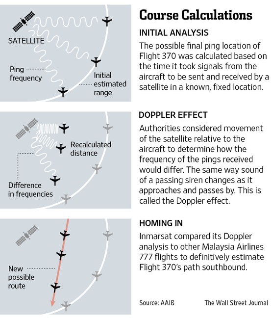
Inmarsat was able to correlate two streams of data to form a more precise picture of where the Boeing 777 may have ended up, Mr. Farrar said. The initial data stream focused on the timing of the "pings" from the plane, he said, revealing distance from the satellite. The later stream focused on frequency changes involving the "Doppler effect," he said, revealing the plane's speed.
The Doppler effect has to do with changes in the frequency of a moving source of waves relative to an observer.
"It shows there is a lot more information hidden in what appears to be simple satellite data," Mr. Farrar said. The latest analysis also indicated "there is a higher likelihood of the plane ending up in certain parts" of the southern arc.
We are being led to assume that Farrar was involved with Inmarsat, and knew the "minute" data closely. In short, Doppler promises to make Inmarsat capable of determining the direction of flight.
What Mr. Farrar is suggesting, therefore, is that Inmarsat had no other, or previous, means to determine the plane's direction. Yes, that's right, because Farrar is stating that this Doppler-effect data is a breakthrough for deciding whether the fact of the matter was the northern or southern route. Previously, without the Doppler effect, Inmarsat claimed that it could not tell what direction the plane was moving, whether north or south of the equator, but now, with Doppler, it's supposedly certain that the plane went south. (If it can be shown that Inmarsat did have capability, from the beginning, to know the plane's direction apart from Doppler, then it would tend to reveal that Inmarsat has been lying.)
Doppler in itself allows the investigator to know only whether the plane is moving further or nearer to the satellite, not whether it's moving north or south. Keep in mind that the power level of the signal at each ping (nothing to do with Doppler) tells Inmarsat whether the plane is nearer or closer to the satellite on an hourly basis. That is sufficient to establish a general flight path...if the location of the plane, relative to the earth, is known by another method. One can use this method of ping analysis in the other direction, to prove that Inmarsat has been lying.
Inmarsat needs to be asked this important question: "Can your satellite determine the earthly coordinates of a plane from its handshake reception in conjunction with other capabilities employed by the satellite, yes or no." We only require a "yes" to make Inmarsat the villain in this affair. After that, all talk of Doppler will be irrelevant.
Lets slice up Farrar's statement to see how hollow and useless it is: "The initial data stream focused on the timing of the 'pings' from the plane, he said, revealing distance from the satellite. The later stream focused on frequency changes involving the 'Doppler effect,' he said, revealing the plane's speed." How does knowing the relative distance to the plane, in conjunction with knowing its velocity, indicate that the plane went south versus north? It doesn't, wherefore Inmarsat yet needs to explain how it knows that the plane went south?
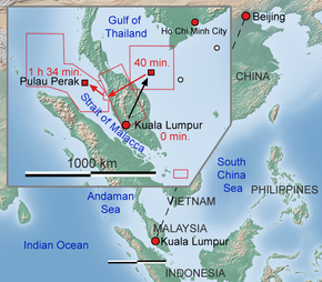
According to the Malaysian radar, the plane, during the second ping, at 2:11 am, was traveling due north toward Phuket (coastal west Thailand). The radar supposedly lost the plane midway (at 2:40) to the third ping at 3:11. Therefore, if Inmarsat is telling the truth, the Doppler effect, or any other gleanings from the second ping event, must be radically different than the ping events where the plane was headed due south.
Inmarsat has claimed that the plane became more distant from the satellite during the pings (not expected to include the first-to-second ping event, however), although this had not been spelled out, ping by ping. We should get it spelled out. According to the line of flight claimed by the Malaysian radar for between the second and third ping (see "GIVAL" in my initial work for that), the plane was headed almost a perfect northwest, slightly less than at 45 degrees from the equator. It was therefore, more or less, keeping the same distance from the satellite (over the equator some 2500 miles west of Malaysia).
In order for the third ping to have been further from the satellite than the second ping, the plane would have needed to turn drastically. One option would be a turn of 180 degrees, back to Phuket, but that's ruled out because the Malaysians would have caught it on radar. The only other option (while keeping the requirement above) is a roughly 90-degree turn northeast, toward the Burma coast. If it turned at 2:41, it would have had 30 minutes before 3:11 ping time to fly to a point further from the satellite as compared to the second-ping location. If the plane turned at 2:41, it would have been no problem to make that requirement, but it would bring the plane to the Burma coast, and over many islands there. It assumes that the pilot decided to cross the Burma land mass, but, for most of us, I think, that is out of the question in a hijacking situation. It would have been nearing the city of Myeik with a population of over 200,000.
Therefore, the third ping event was NOT with the plane further from Inmarsat's satellite than at the second ping (satellite was at 64.5 degrees longitude). The Inmarsat data would need to bear that out.
The problem for the southern route is no small one. As was said, it's out of the question for the plane to have turned straight backward (southeast), after 2:40, toward Phuket. The best option for keeping to Inmarsat's claim is due south. In that picture, both the third and fourth ping events would fail to locate the plane further than at the second ping. Moreover, the plane at the fourth ping would be nearer to the satellite than at the third ping, a problem for Inmarsat's claim. Here's what Chris McLaughlin, Inmarsat's vice-president, said: "We couldn't say what direction it had gone in, but the plane wasn't standing still because the signals were getting longer, i.e. further in distance from our satellite."
He did not give an exception for any ping, i.e. he's suggesting all ping events show the plane flying progressively further away from the satellite. I understand that it was a general statement; what I don't understand is why Inmarsat isn't showing a ping-by-ping description of the flight. What's the big secret? Why shouldn't the world know what the plane supposedly did, ping after ping? It's not too much to ask, is it? This is not a military top-secret situation...or is it???
After the fourth ping upon the south-corridor scenario, the plane needs to do virtually perfect circle around the satellite until the 8th ping, thus ending up in the middle of the vast ocean with nothing there, and headed to Antarctica. Does that make any expletive sense to you at all. Inmarsat did not apparently hesitate at all when sending search parties to such a ridiculous sea hunt.
Here's Inmarsat's vice-president:
The mathematics-based process used by Inmarsat and the UK's Air Accidents Investigation Branch (AAIB) to reveal the definitive path was described by McLaughlin as "groundbreaking."Here's how the process works in a nutshell: Inmarsat officials and engineers were able to determine whether the plane was flying away or toward the satellite's location by expansion or compression of the satellite's signal.
What does expansion or compression mean? You may have heard about something called the Doppler effect.
...The new calculations, McLaughlin said, underwent a peer review process with space agency experts and contributions by Boeing.
Notice that individual pings are still not being mentioned, as though the company warned all spokespeople not to discuss them. At which ping did the plane start to move south? It's a simple question, for a simple phone call. Make Inmarsat commit to describing the individual pings in order to tighten its story, or there will be too much freedom to alter their story later to fit the new line of questioning that may crop up. People in the game of fabricating evidence will reveal as little as possible, and only what's necessary to correspond with the going questioning.
Could CNN dig in and get some satisfying information that either corroborates or denies Inmarsat's analysis? Or does CNN want to do nothing but applaud the experts and act as their blow horns? Inmarsat isn't explaining anything while using the "groundbreaking" word. CNN's science-nerd piped up:
"If you sit at a train station and you listen to the train whistle -- the pitch of the whistle changes as it moves past. That's exactly what we have," explained CNN Meteorologist Chad Myers, who has studied Doppler technology [plus, he believes in the Big Bang and other cosmological fantasies]. "It's the Doppler effect that they're using on this ping or handshake back from the airplane. They know by nanoseconds whether that signal was compressed a little -- or expanded -- by whether the plane was moving closer or away from 64.5 degrees -- which is the latitude [no, its the longitude] of the orbiting satellite."Each ping was analyzed for its direction of travel, Myers said....
It's possible to use this analysis to determine more specifically the area where the plane went down, Myers said. "Using trigonometry, engineers are capable of finding angles of flight [I would advise disregarding that last comment]."
http://www.cnn.com/2014/03/24/world/asia/malaysia-airlines-satellite-tracking/
This tells us nothing. What we need to see before applauding is the individual ping interpretations. According to the Malaysian-radar claims, the plane was moving further from the satellite at the second handshake. Does the Inmarsat satellite bear this out with "expansion" of the signal wave?
The analysis of the third ping is the most-important one. Did the third handshake expand or compress? They seem like simple questions for CNN to ask of Inmarsat, if it truly wishes to be a reporter rather than an Inmarsat fan club. Hello, are there any reporters left at CNN, or are they all mouthpieces for the powers that be?
If the third handshake was compressed, then, yes, that would indicate the plane turning from it's north-west direction more toward the south than north-west. It could begin to describe a turn toward Antarctica. But if the third-handshake signal came with expansion, moving further from the satellite, then the plane may have been moving either north or south. That's the importance of the third ping. And, as the Malaysians had it, the plane was headed on a 40-45-degree path north-west some 31 minutes before the third ping. It's not time to applaud Inmarsat yet. Mr. Myers, sit down.
If you're confused, let me explain it. Individual handshakes can be viewed as bullets, each handshake signal equal to one bullet. The harder the bullet comes in to the satellite, the closer the plane to the satellite. But in the Doppler effect, each handshake signal is analyzed like a flow of many bullets as though from a machine gun. "Compression" means that the bullets are coming in higher numbers per unit time as compared to a machine gun firing bullets from a stationary plane. Expansion is the opposite, fewer bullets per unit time as compared to a stationary plane. Your house will get more bullets per second from a machine gun on an airplane that's flying toward your house than when its flying away from your house. Easy enough to understand.
An individual handshake (it's defined as the plane's response to the satellite's ping signal) can tell whether the plane is becoming closer or further than at the previous ping, while the Doppler effect can tell the relative angle of the plane, in regards to the satellite coordinates, at any one handshake. For example, when the signal / wave is neither expanded nor compressed, the side of the plane is squarely facing the satellite. When the compression is at maximum, the nose of the plane is headed directly to the satellite.
"Expanded" and "compressed" are relative, however, depending on what middle ground is defined as. The terms can be expressed as "left extreme" and "right extreme," or as "less dense" or "more dense."
Wonderful. But are they fabricating the handshakes? Where did they really get the handshakes, from flight 370 or another flight? If they fabricated them, they wouldn't want to publicize the Doppler results, or any results, ping by ping especially. And that's what we have thus far: no ping-by-ping description.
If the maximum and minimum compression / expansion is known, they can determine the precise angle of the plane in regards to the satellite's coordinates. The problem is, they can't know the maximums or minimums without other information not having to do with Doppler. To be sure that they are in the pioneer stage: "Using a type of [Doppler] analysis never before used in an investigation of this sort, they have been able to shed more light on MH370's flight path." If they have never studied their own handshake signals with the express purpose of straining out the Doppler ingredients, they are indeed in a vast ocean of uncertainty. To be sure, they would be guessing as to the angle of the plane at each handshake unless they knew the plane's position by some other method at more than one ping event.
Let me put it this way: if they don't know what the signal needs to look like when it's neither compressed nor expanded, how can they determine any angle at all? They can't. There is nothing in the wave in itself to indicate whether it's expanded or compressed. You can't know whether the machine gun's bullets coming at your house are from an airplane moving toward the house, or across the house, or away from the house, unless you count the bullets per minute AS WELL AS know beforehand how many bullets per minute there are when from a plane parked in a stationary position (i.e. the middle ground).
If the Inmarsat people knew as a certainty the precise position of the plane at any two ping events, they could use the comparison between the two signals as a guide for interpreting the angle of the plane at all other ping events. As they know the precise position of the plane at 1:11 because it was still on it's normal flight path to Beijing, it is one fantastic stroke of "luck" (spit!) that they knew the plane's precise position at 2:11 because it was moving between VAMPI and GIVAL. There you have what could be the evidence that this was all a pre-determined plot by globalist murderers. They may have arranged beforehand to provide a know-able plane position at the second ping so that they could have "proof" on how to read the Doppler effect, and thereby how to describe the plane's position at the all-important third ping.
It was a mystery to me as to why the plane zig-zagged north from VAMPI to GIVAL. It made little sense either in a hijacking scenario or in a plane-failure situation. The plane was flying southwest before turning sharply at VAMPI. From there, it was a short, 65-mile flight northward (seven-minute flight) to GIVAL, assuring that the plane would always be pointed in the same direction throughout that stretch. As long as their plane (not flight 370) was anywhere on that 65-mile stretch at 2:11 ping time, they would be able to claim the position of the plain relative to the Inmarsat satellite. Again, Reuters reported that the plane was at GIVAL at 2:15, meaning that the plane was midway on the 65-mile stretch at 2:P11. MIDWAY!!!
Midway means there can be no doubt about the plane's position. Midway makes it look as though the task was conducted by experienced pilots bang-on-time.
Then, by comparing the angle at handshake one versus handshake two, as well as comparing the Doppler values at each handshake, they could (with the right specialist) determine the Doppler value for the plane at any angle whatsoever. They could then predict the angle of the plane at ping three.
Therefore, the non-insider experts all around the discussion tables saw that, at ping three, the plane had turned south. But, the question is, where did Inmarsat get this third handshake (and all handshakes to follow), which was fed to the non-insider experts? The handshake would have been nothing but markings / lines on a piece of paper. They could have used handshakes from any flight whatsoever. The experts would have trusted that these were from flight 370. No one would have asked any questions...unless faults in the plan developed.
You see, if the plane had not taken the path from VAMPI to GIVAL, it would have been impossible to claim to know what direction its nose was pointed at 2:11. It's as simple as that. The fact that a plane acting as flight 370 was midway between those two waypoints merely seven minutes apart serves as evidence that this is a contrived sham performed and conducted by winking, world-class murderers all in collusion. It's not possible for this to have taken place unless some of the guilty were at the meetings discussing handshake interpretations.
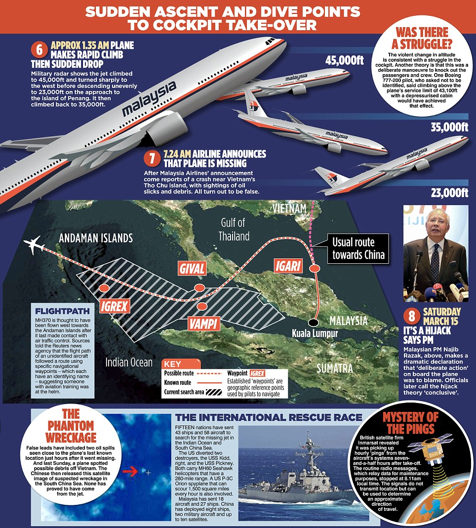
There was evidence already that those in Malaysia, who claimed this to be flight 370, were in error. In fact, after writing the above (on the 24th), I got to Wikipedia's article on this disaster for the first time, where it was learned that "Military tracking shows that the aircraft descended as low as 12,000 feet after taking a sharp turn toward the Strait of Malacca." I had not read of this flight level in any news article. It jibes much more with the low flight of the two Malaysian witnesses than it does with the 45,000-foot story reported by the NY Times.
Plus, Wikipedia does not have the last radar contact at 2:40, as the Malaysians claimed, but at the 2:15 point beside GIVAL. It obliterates the north-west route of the plane toward IGREX, perhaps a thing that the insiders need for interpreting the third ping event.
Looking into the 12,000-foot report, it turns out to be a very new claim. Here's CNN on March 23:
...authorities released new details that paint a different picture of what may have happened in the plane's cockpit.Military radar tracking shows that the aircraft changed altitude after making a sharp turn over the South China Sea as it headed toward the Strait of Malacca, a source close to the investigation into the missing flight told CNN. The plane flew as low as 12,000 feet at some point before it disappeared from radar, according to the source.
The sharp turn seemed to be intentional, the source said.
The official, who is not authorized to speak to the media [but did anyway], told CNN that the area the plane flew in after the turn is a heavily trafficked air corridor and that flying at 12,000 feet would have kept the jet well out of the way of that traffic.
...CNN aviation analyst Miles O'Brien called the fresh details about the flight a "game changer."
..."Now we have no evidence the crew did anything wrong," he said. "And in fact, now, we should be operating with the primary assumption being that something bad happened to that plane shortly after they said good night."
...Military radar tracked the flight between 1:19 a.m. and 2:40 a.m. the day it went missing, the source told CNN, but it's not clear how long it took the plane to descend to 12,000 feet.
There you have the 2:40 time that Wikipedia has omitted. Many webpages are expected to report Wikipedia's 2:15 version. Either way, the pilot was headed north at that time, not expected to turn toward the Antarctic.
It was Wikipedia that earlier said: "Malaysian military radar showed the plane climbing to 45,000 feet soon after disappearing from civilian radar screens and then dropping to 23,000 feet before climbing again, the official said." Why did the Malaysian military change its story? Who was responsible for the fabricated 45,000-foot story? This alteration comes after Thailand radar weighed in. Also, aside from Reuters, few media latched onto the VAMPI-to-GIVAL path of the plane, and most maps (like the one at the link above) do not show this. Was it meant to be kept a secret? Reuters had quoted Malaysian officials concerning the taking of that 65-mile pipe.
Why did Malaysians subscribe (for lack of the truth-reflecting term) to the 45,000-foot idea? In the least, we should not blindly trust the Malaysians and those who may be putting false words into their mouths or false ideas into their heads. False reports, such as this entails, are evidence for foul play as much as evidence for mere error. The trick is to discover where the Malaysians have been lying due to certain O-mericans pulling their strings.
This sudden drop to 12,000 feet, perhaps because it's not expected by a hijacker, has the news people painting another picture, one of an accident on the plane. Yet, I hope you're not naive enough to believe that a pilot in trouble is going to take the plane north-west toward India, or north toward Burma, rather than back to the airport. I explained why he may not have wanted to go back to the airport. If the plane was unable to land, and in serious jeopardy for crashing at any moment, it would have been the right decision to stay close to water on the east side of Malaysia, in hopes that military radar would see him flying about.
But the military did not send jets to check out the plane. The pilot realized, by 2 am, by 2:15 at the latest, certainly, that the Malaysians were not watching their radar screens. He therefore needed to adopt another plan. He went toward Vietnam in hopes that their radar might spot him. And that's where I say his plane crashed, 95 miles south of the southern tip of Vietnam. The O-mericans knew it (as the evidence suggests) because they were watching from their eyes in the sky, and they expectedly showed strong desire to clear those waters of all search parties.
So, as it stands in the second week, the Malaysians are, apparently, quietly changing their 45,000 story to a 12,000 story, which will make the family members of the passengers all-the-more suspicious of their government. Be open to the idea that the nameless source reporting this 12,000 story may be angry / vengeful with Malaysia because it adopted the southern-corridor theory after first going with the northern-corridor theory. In other words, he and his 12,000 story may be from insiders/perpetrators. Expect them to be some of the biggest mouth pieces through blow-horn media.
On the other hand, the source could be using the blow horn as per his team realizing the inevitable, that the Malaysians are bound to abandon the 45,000 story too, wherefore the insiders wish to paint their own picture of why the plane descended, before others weigh in. A SHARP TURN immediately doesn't seem like a hijacking, does it? This detail is expected to throttle those who desired a hijacking picture. There's little use in the perpetrators taking a hijacking picture any longer, and the weighing in of the Thailand radar may have been the very thing that put an end to the 45,000 story. The perpetrators, seeing the inevitable, might now lean toward a fire-on-board scenario, but, the problem is, it takes more than a fire between 1:19 and 1:21 to knock out both transponders and the voice radio. That sounds more like an explosion...or an EMP attack.
Yes, an explosion does not knock out cell phones.
The source has a curious way of putting the following, using "would have taken" rather than "took": "The sharp turn seemed to be intentional, the source said, because executing it would have taken the Boeing 777 two minutes -- a time period during which the pilot or co-pilot could have sent an emergency signal if there had been a fire or other emergency onboard." Nobody knows how long the turn "would have taken," unless there is some indicator, in which case the source should have said, "took." He apparently did NOT wish to reveal as fact that the turn took a mere two minutes. But he now has no choice, for Thai radar had the plane back toward shore at 1:28, and that requires a fast turn. If it took two minutes, there was only five minutes left for the 1:28 time.
That would tend to plot the plane about 40 miles (toward the coast) from where it was at loss-of-transponder time (1:21). Wikipedia gives the precise coordinates of the plane at 1:21; my calculations show it to be 85-90 miles straight off the coast from the southern Kelantan border, smack where the fisherman witness was located. As he was eight to ten miles off the coast, while the plane was about 50 miles from the coast at 1:28, the plane must have been flying over his head at about 1:33 (he claimed 1:30, which sounds like an approximation).
We don't expect a bomb to put out the cell phones on board. We'd expect the pilots to have cell phones. A cell phone can reach a tower 10-15 miles away. But a plane eight to ten miles from the coast is predicted not to reach cell towers, but the first thing a pilot would do in a loss-of-radio situation is to get over land in order to use his cell phone. Eventually, the pilot may have realized that his cell was dead already. He may have learned that the phones of all passengers went dead. He may have realized an EMP attack, therefore.
The 45,000-foot report may have been born by those who wanted to explain the lack of cell-phone calls. If they could convince us that the plane was more than eight miles high, perhaps they could use that to explain the apparent fact that not one call was made. The Americans may have been repeating that fact to the Malaysians until they decided the great height had to be true...in which case the radar wasn't the thing used as basis for that great height. But at 12,000 feet (little more than two miles), that argument no longer holds; we are left with the cell-phone mystery.
The perpetrators may have planned to use an argument where hijackers forbade anyone to use a cell phone at the pain of being shot on the spot. But how many hijackers could there have been in the isles overseeing the passenger seats? You would think that at least one brave or terrified soul would make the attempt to call / text somewhere while crossing Malaysia. But even if not, a terrorist scenario with the intent of flying seven hours northwest of Malaysia would have hijacked a different plane, don't you think? Shouldn't they have taken a plane closer to their destination? A hijacking scenario to a suicide in the Indian ocean has already been ruled out as highly unlikely.
One could now take careful note of anyone in high places who blow-horns their hijacker scenario on the national news. Or, perhaps the perpetrators have decided to go with a different scenario. Perhaps they will succumb to the Indian-ocean theory.
The news media now need to draw diagrams showing the electrical circuits (their positioning) of both transponders, the ACARS system, and the voice radio at the cockpit. We need to know whether one on-board explosion or fire could knock all of them out simultaneously (or virtually so). It's understandable that the airlines don't wish to reveal this information for security reasons. The airlines could be called to answer a simple question: could a single explosion or fire at one location explain the circumstances of flight 370 at 1:21 am?
At 1:19, a voice from the cockpit said, "good night." It doesn't sound like there was a fire at that time in the cockpit, or in the passenger area. Could a mouse have started a fire in the cargo area several minutes before 1:21? Are there no persons riding in the cargo area to assure that all is well down there? Are there no TV screens in the cockpit to show the scene on camera in the cargo area? Wouldn't the cargo area have fire detectors for to sound an alarm? It looks very bad for a fire scenario, does it not, to explain the black-out at 1:21? Why would some experts even bring up a fire, therefore? If they are experts, shouldn't they know something before talking? Shouldn't they explain how a fire could knock out so much all at once?
Aside from loss of the electronic equipment under discussion, the plane was unable to fly to the airport. Moreover, its red lights were not on, according to Alif, a witness of the flight. Don't you find it amazing that CNN has not concerned itself with a story on Alif, and the possible circumstances of the flight from that perspective? Should we lump the owners of CNN in with the perpetrators? Did CNN grudgingly do the story on the 12,000-feet altitude because it had no choice when a certain reporter made it a story? How do the bosses say to a reporter, no we can't do that story, without a reasonable excuse?
Were the plane's guidance systems ruined? Was auto-pilot ruined? Were many of the gauges ruined? I understand why CNN wouldn't want to engage an EMP scenario, as the Americans may be the only ones, in this particular picture, who could be suspect for such a thing. An electromagnetic-pulse attack is expected to put out the engines by crippling the electronics that the engines depend on, but if the EMP weapon doesn't get close enough to the target, some electronics on the plane could survive. We can be sure tat the U.S. military knows how to ruin cell phones by EMP:
Military anti-missile system technology. We bought the Electro Magnetic Pulse technology and had a leading lab downsize the design so that the same technology used to bring down a missile can now be yours to "cook" the circuitry in a cell phone. One touch of a button sends out a powerful electro-magnetic pulse wave that fries the circuitry in a cell phone instantly...Special order only. Range is up to 30 feet. From Stubbco [under $80].Let's go back to Alif's testimony (round brackets not mine): "'However, the light I saw was moving towards a completely different direction [from normal airliner traffic.] It was going towards the sea, near Bachok (which lies to the south of Mr Alif's home).' His description tends to indicate that if the light he saw was on the doomed aircraft, it had turned north instead of continuing on its regular north-easterly flight path." The land mass of Malaysia at Alif's house and at Bachok is at roughly a 45-degree angle to the equator, meaning that a plane headed north through Bachok would indeed be headed for the sea. The point is, the plane was over land when Alif saw it, for south of Bachok, it is land, and, besides, the statement wouldn't make good sense if the plane was already over the sea.
What I'm trying to say is that a conspiracy did occur, quite obviously. It is this little lucky-strike detail, that the plane had flown over land at and before about 1:45, and even over the populated area of Pasir Puteh (population about 135,000), just 20 miles due south of Bachok (population about 140,000), that provides super evidence for an electromagnetic-pulse attack. The plane had flown over an area of cell towers!
Even if the pilots realized while over the sea that their cells, and those of passengers, had been ruined, the first thing on the agenda, without radio contact with an airport, would be a low fly over a populated area, just in case one cell phone survived. If no phones were operating, the next item on the agenda may logically have been to establish radio contact with that plane that was contacting him.
Wikipedia gives the time of 1:30 for some radio contact with the flight. I shouldn't have said that radio contact was lost at 1:21, for in fact it was still working to a small degree at 1:30, if the following is true:
The crew were expected to contact air traffic control in Ho Chi Minh City as the aircraft passed into Vietnamese airspace...The captain of another [unidentified] aircraft had attempted to reach the crew of Flight 370 "just after 1:30 a.m." to relay Vietnamese Air Traffic Control's request for the crew to contact it; the captain said he was able to establish contact, but just heard "mumbling" and static.Hijackers are unable to create radio static, safe to say, in the other guy's plane. "Mumbling" shouldn't necessarily be interpreted as talk from a semi-conscious individual, for it may have been a bad choice / translation of word that had been intended as "unclear / unintelligible" speech due to the static.
Now that I'm confident that the plane was heading north at 1:30, about three minutes before flying over the fisherman, I can attempt to answer why the plane ended up off Vietnam at 2:50 am. The pilot, having heard the other plane attempt contact, may have realized that it was the Vietnamese, and so he circled round hoping to get closer to that plane in order to have better radio contact. He thus flew toward Vietnam, and perhaps he flew a large circle or two in the gulf, while the other pilot worked his radio all the while. Woe is me if I even suggest that the Vietnamese shot him down, for that would be like a conspiracy theory.
Did the Vietnamese think this plane was hostile? It may have entered their minds, but sound heads should have prevailed. The Vietnamese knew that a 777 MA jet was scheduled to approach Ho Chi Minh at about 1:50, and one could assume that the latter called the Malaysian airport of departure to inquire as to what the problem may have been. I have no idea what the Malaysian airport may have said, and have read nothing on this particular topic by anyone.
Interpreting the News at Stage TwoI should take a moment to express my deep sorrow for passengers on flight 370. The horror that grips a person knowing that a plane is going down to a crash is unimaginable. The idea that some government agency should decide that time is up for the lives of that many people simultaneously is a great horror. The idea that a government agency should decide that these people are expendable by such cruel method of death for merely a political tit-for-tat or commercial gain is brutal. I cannot imagine the torment that God will enforce upon anyone who partakes in such a thing. It's a lose-lose all round, and includes the American people who live under the thumb of this sort of government.
I do not believe that, in a war started by the political heads, civilians can be justifiably targeted en-masse. This is a beastly way to go about warfare. If the enemy does it, it doesn't mean that the opposer must do it. If the enemy is the Chinese government, you don't kill irrelevant Chinese people if you are a decent government head.
I haven't proven that an EMP attack by the Americans caused this disaster, but I feel I am close to doing so. As anyone, I could be wrong. I may have plenty to lose if correct. It's dangerous to pipe up against the U.S. government. It is not ruled by angels. Obama wants all citizens to fear writing things in opposition to him; he wants all Americans to think that their writings are being watched. Only a small percentage of emails and writings can be read by the government, but it would be easy to find my article should they just search "flight 370 EMP." They could quickly find all people suggesting that idea, and can then deal with them if they chose.
Jesus was very stern about matters such as this plane "accident," saying that all sinners are subjected to death at any time by any means with God doing nothing about it. It's not Him who's cruel toward man, He says, but man who is cruel toward Him. The liberal would like to turn that statement upside-down. Unless we repent, said Jesus, a tower can fall upon us without God doing anything to save. Jesus was blunt. Yes, God makes the sun to rise on the evil and the good, but as man as had a hands-off approach to God, God has had a hands-off approach to man. Did God build the tower that fell on people that killed them? Did God build the plane that went down and killed the people who boarded the plane of their own free will?
Why would God save one plane but not another? We need to ask the sinners on board, let's make no mistake about it. Even so, we feel for them, their terror, and the levels of insanity that must have gripped their souls as the plane went down.
Fox has an article entitled, "Malaysia Airlines defends text message to families as China demands satellite data,"
yet the article says nothing about that demand. It does say that China is sending a high-level foreign-affairs envoy to Malaysia to inquire on why the Malaysian prime minister has abruptly / prematurely announced a dead-end to the search. Indeed, it is premature because it places full confidence on Inmarsat's conclusions. Inmarsat will, hopefully, come under the Chinese microscope.Clearly, with little of the Indian ocean searched to this point, the leaders of the hunt are claiming that Inmarsat's plotting of the plane is absolutely full proof. No use looking anywhere else, the prime minister is saying, because the plane came down in this part of the world. Less than ten days earlier, he was saying that the flight may have landed on a Kazakhstan runway.
Hopefully, China will get both the radar data and the Inmarsat data, and the reveal to is all where the Chinese scientists disagree with any of it. I should especially like to know. I have a hard time believing that Malaysia would share the radar data with the U.S. but not with China. In fact, shouldn't Malaysia have offered the radar data to China out of courtesy and respect for the lost Chinese citizens? Yes, of course, but we wouldn't expect it if the Malaysians are misrepresenting the radar data.
KUALA LUMPUR, Malaysia (CBS/AP) -- China demanded that Malaysia turn over the satellite data used to conclude that a Malaysia Airlines jetliner had crashed in the southern Indian Ocean......Deputy Foreign Minister Xie Hangsheng told Malaysia's ambassador to Beijing late Monday that China wanted to know exactly what led Najib to announce that the plane had been lost, a statement on the ministry's website said.
China's not only going for the radar data, but the satellite data. If China comes out with a statement to the effect that Inmarsat interpretation of the ping data is bogus, stay tuned. If not for the Malaysian prime minister making yet another mistake, this might not be happening.
If the prime minister knows that the plane had crashed in the Gulf of Thailand, he will predictably announce prematurely that there's no use holding out any further hope. As would be his private hope, he could cease as soon as possible in the task of seeking in vain for the plane where he knows it's not. It must be like one throbbing migraine to try to act like it's in the Indian ocean when he knows it's not. China is upset:
Chinese Deputy Foreign Minister Xie Hangsheng held an urgent meeting with Malaysia's ambassador to Beijing, Iskandar Bin Sarudin, late [March 24] to demand that Malaysia provide "all information and evidence" relating to the data, the official Xinhua news agency reported Tuesday."We demand the Malaysian side to make clear the specific basis on which they come to this judgment," Xinhua quoted Mr. Xie as saying. "We have noticed that the Malaysian side said it will make further elaboration on related details."
http://stream.wsj.com/story/malaysia-airlines-flight-370/SS-2-475558/SS-2-490242/
What is amazing is that China sent its ships to the Indian ocean before seeing the satellite data. More amazing yet, China removed its ships from the gulf of Thailand even though there was a report from China itself of a timely seismic event in that gulf. I've never read that China searched that area of the gulf to rule the "quake" out as the crashing plane. Better late than never: "China's Foreign Ministry said on Tuesday [March 25] it hopes Britain will provide satellite data by British firm Inmarsat on the missing Malaysian Airlines plane"
One would think that the British Broadcasting Corporation would have a story on China demanding data from a British firm, but, amazingly, as of Tuesday evening, nothing. It's as though the owners of the BBC were in cahoots with Inmarsat. BBC jumped right to it, however, as per being an Inmarsat mouthpiece on the "new data." BBC was one of the news organizations, including CNN and Fox, which announced the fall of Building 7 of the World Trade Center about a half hour before it fell, revealing that the entire 9-11 disaster was a globalist fake job that included British elements. There is no other way to interpret that news coming prior to the fall, for it is inexplicable to begin with that Building 7 should fall completely to the ground. It fell identical with a typical take-down by an explosives team.
Likewise, CNN has failed to bring to light China's demands on the data. When China uses "demand," it's mad. The Fox headline promised to tell of this demand, but then there was nothing in the article. Was the piece removed from the article by request?
My prediction is that, if China is a major complication for the perpetrators, the latter will just dump floating objects, such as suitcases, into the Indian ocean and then "find" them, thus "proving" that the flight crashed there. It would be especially delightful (for the perpetrators) to do this after China's criticisms of Inmarsat are announced in the news.
At the bottom of the BBC page for March 25th, a small link to a Chicago-Tribune article as per China's demand of satellite data. Don't you think the BBC should get on the phone with Inmarsat to see what it has to say about it, whether it will share data with China? Hello? Is the BBC organization into cutting-edge news, or just blow-horning the messages of its friends?
I can tell you this: Inmarsat should be compelled by the BBC's of the world to share the satellite data openly with the world, never mind only China. If the BBC is involved in coaxing the people of the world to read it's news, it had better serve the readers of the world rightly. If the BBC is going to coax the peoples of the world to read its flight-370 updates, it had best not seek to hide the story's most-important news.
The Times UK on March 25??? Out to lunch, no China story either, wouldn't want to offend Inmarsat or the Air Accident crew. The next day, the Telegraph mentioned China's skepticism in passing, but in the very next paragraph wrote, "which flew on for seven hours after it vanished from radar," fully in trust of Inmarsat's claims. Is the Telegraph truly a tool for ferreting out the truth, or just a common political trowel for plastering a white stucco over the dark underlay?
A Chinese news media says that Chinese leaders are asking Malaysia to "absorb Chinese experts to join the in-depth investigation." That seems logical. Shouldn't news organizations say, ok, let's look at the ping data. It's what the interested readers want, a critical analysis of the Inmarsat analysis.
The New Straight Times (Malaysian news) did not have a headline/story to attract attention to the Chinese demand. It's false-news reporting when only half the story is told. The Malaysian prime minister made a conclusion all on his own, with no corroboration from Chinese scientists, that Inmarsat and Air Accident are correct in their analysis. Is the prime minister qualified for such a conclusion? Isn't that question alone a newsworthy story? How can it be a story worthy of readers unless the data is put on the table for judgment?
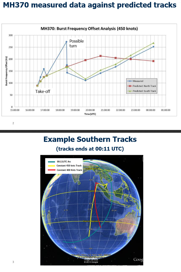
Here's something new to me from the New Straight Times: "In order to establish confidence in its [Doppler] theory, Inmarsat checked its predictions using information obtained from six other B777 aircraft flying on the same day in various directions. There was good agreement. And there we are, there was good agreement, therefore we are to trust in that statement. If Inmarsat is so confident of its work, just release some pictures to show which direction the plane was pointing at each ping event. What's the problem? Is Inmarsat unwilling to commit to any plane positions in case it needs to change them when others look at the data? Why won't Inmarsat even begin to tell us where the plane's nose was pointing at the all-important third ping? And while it's at it, throw in the fourth ping too. Don't be stingy. No one likes a miser.
When an organization decides to commit a crime, it doesn't want to commit more law-breaking acts than needed because, if caught, it increases the punishment from a court. To put out the ping data as true data, if it's faked, only increases the sentence if found guilty. Every move to deceive for the purpose of covering up a crime is a criminal violation.
The Telegraph, on March 26, is airing Inmarsat's latest twist, though it's not originating from Inmarsat, but rather from the Malaysian government under pressure to shore-up the prime minister's conclusion:
"Adding another puzzle to the list of questions over the flight, which flew on for seven hours after it vanished from radar, Malaysian authorities said that the plane appeared to make a final satellite contact after the last of its routine electronic "handshakes" was emitted. There is evidence of a partial handshake between the aircraft and ground station at 00:19 GMT," said Hishammuddin Hussein, the acting transport minister [of Malaysia]. "This transmission is not understood and is subject to further ongoing work."...Thomas Withington [where did he come from to have input on this?], a defence electronics analyst, told The Telegraph: "It sounds like the aircraft began to squawk a message and for some reason this was curtailed. It could be because the aircraft was at a catastrophic phase of its flight -- that something was causing it to crash -- or there could be some atmospheric disturbance.
Withington says, "it sounds like..." Has he heard the report on this matter from Inmarsat's data itself? Is he an insider? Defence electronics is just what the perpetrators would use for creating EMP-attack capability.
You can't have a ping system set hourly to send a ping at any other time. So, why are the Malaysians even calling it a "partial handshake"? Who put that phrase in their heads if not for Inmarsat, and/or the Air Accident people? The idea that it's partial sends the message that it would have been a full one had the plane not crashed right then. That, apparently, is the crock that the Malaysians were fed. But the owners and manufacturers of the airplane would know best what this is, and it's not likely a mere handshake at all. So why did Inmarsat call it that?
Perhaps it didn't want to let on, to non-insider peers, that the plane is built with devises detecting dangerous circumstances in which automatic messages are transmitted, whether transponders are on or off. A good example is a smoke-detection devise transmitting a message not only to the cockpit, but to ground stations...that can be picked up by Inmarsat too. Another example is for the breaking of the aircraft skin so as to lower the plane's air pressure. It seems reasonable enough to have such devises on board. So, what would such devises do if the plane was hit by a missile that broke the skin of the plane and also caused a fire?
What happened, apparently, is that the Telegraph caught wind of this final message, and did it's job partially by inquiring about it, though it has yet to do its job fully: "The crashed Malaysia Airlines flight gave one last unexplained signal eight minutes after its final "ping", possibly the result of the plane entering its "catastrophic phase" as it plunged into the Indian Ocean, investigators have said." It's the nameless investigators again, to be suspect as crock-a-gators so long as they remain faceless sources of information.
Since when does an aircraft have a "catastrophic PHASE." It sounds as though it's such a natural part of an aircraft's life. And the aircraft is even a living thing, in this case, because it squawked as it was in the throes of death. The plane "knew" it was about to taste death, and squawked an SOS, save me.
The picture is that the plane sent a message precisely due to plunging or striking the ocean rather than the cause of plunging. First, we were told by Inmarsat that the plane probably ran out of fuel, which doesn't necessarily give cause for a special transmission. The plane can basically glide when out of fuel. It has time to send a long, FULL SOS under that scenario. But this crock-a-gator wishes, if I'm reading him correctly, for us to believe an OUCH-THAT-HURTS signal was PARTIAL, like when it was half in the water, and half out (not having enough time to send the full message).
Inmarsat was less flamboyant: "a failed login"...or as a "potential attempt by the system {aboard the aircraft} to reset itself," Mr. McLaughlin said...human interaction with the satellite communications system had been ruled out." Still, there is no reason to call it a handshake, only to confuse matters. It was not on the hourly ping timetable, and so should have been something separate. However, as the plane was not flying at the time, this looks like another attempt to establish that very fantasy. My position is that the eighth ping was in reality the third ping at 3:11, and that Inmarsat falsified the other five. In this picture, the "partial" signal was possibly a missile strike.
http://foxnewsinsider.com/2014/03/25/wsj-flight-370-sent-%E2%80%98partial-ping%E2%80%99-could-help-investigatorsWhen was the last time that you heard of a plane sending an SOS upon striking water (or land)? You can be sure: it's a concoction of the shameless, faceless crock-a-gator acting like the expert that you're supposed to trust.
We do not know as fact whether any-such final message was received, but even if it was, it's more likely due to a pilot message or an automatic message sent by a devise detecting an emergency situation. Why did Inmarsat pass this SOS message to the Malaysians but not to the news? One would think that, before passing on such a message to the leader of the search effort, the British would have talked about it with Boeing and Malaysian Airlines. Boeing would have a pretty good idea of what such a message would be, don't you think? Yet the crock-a-gator said "possibly," as if it's just a guess as to why the message was sent. Why guess when you can just ask Boeing? We are still waiting for Boeing to weigh in. It's been rather quiet.
This Was Supposed to be a HijackingThe time has come to ask: was Malaysia complicit in the EMP attack? Did it know from the start that this plane would be downed as an act against China? Actually, it's a terrible question, but then this is a terrible world.
Here's from Wikipedia's article of the disaster, where the Malaysian prime minister again looks guilty of a cover up: "According to the Vietnamese Deputy Minister of Transport, Pham Quy Tieu, 'We informed Malaysia on the day we lost contact with the flight that we noticed the flight turned back west but Malaysia did not respond.'" There are other explanations for the failure to respond, but none as good as an unwillingness to explain why Malaysia didn't wish to face the facts of a neighbor's radar picture. If there was nothing amiss in Malaysia, it would have had the common courtesy to respond with a thank-you note. But, very apparently, the Malaysians were going to go with a radar picture that contradicted the Thai radar, and whatever the Vietnamese had. That could explain no response at all, not even a thank-you.
I've been giving the Malaysian government the benefit of the doubt from the start. However, the more the events transpire, the more the country appears to be clinging to falsified stories. In my mind to this point, there have been two governments drawing a false story, each with a different motive and different particulars to the respective stories. There has been a sick comedy where both governments have been able to borrow or adopt parts of the false stories of the other to further their respective cover-up.
In no way have I been thinking that the Malaysians definitely knew the cause of the downed plane, though they may have realized it for the way the Americans had been applying themselves. The Americans stopped becoming visible in the news ever since they got the ships out of the gulf of Thailand. They must have been very happy to see all emphasis in the Indian ocean, explaining why I didn't read further of Americans kicking up a fuss on CNN.
It has been my growing opinion that the Malaysians provided a false story because their military radar people failed to see the plane in distress, thus allowing it to crash. But could it be worse? Is there any indication that the Malaysian prime minister, and a few in his inner circle, were in on the downing of this plane? Is it really true that the Malaysians were not watching their radar screens when flight 370 was in trouble? Did the inner circle arrange for no one watching the radar at that time? That may have been fairly easy to arrange.
One thing is certain: if the radar was not shut off, the radar caught the flight returning to shore, as per the flight path told by the two witnesses. The question is, what did the Americans, looking at the radar playback, think when they saw this plane taking this path? Whose idea was it initially to have the plane soar to 45,000 feet? Both sides dearly wanted to contradict the two witnesses who reported a low flight. Imagine the farce, where both agree to it without evidence.
I understand how people get their backs up when someone mentions EMP as the method for downing a plane. It sounds so way-out there, a government-sponsored murder of an entire aircraft. I've just read an article pitted with arguments (and some errors) against conspiracy theories in regards to this flight, and when it came time for him to give his position, he said that the pilots CONSPIRED (his word) together to hold the passengers ransom in order to get their political friend out of jail. So, everything he disagrees with is a conspiracy theory, and the only thing that's not a conspiracy theory is his own point of view. He also commended the Americans for sending the USS Kidd to the Indian ocean. And he wrongly reported that the pilot turned off the ACARS system before voice contact was lost, a trick attempted by the Malaysians to convince the world that a hijacking had taken place.
If I say that the FBI has conspired to frame the pilots in such a way as to make them appear like men conspiring to hold ransom the passengers, then it's me who is considered by most to advance the lunatic conspiracy theory while the FBI story is viewed as sound fact. In the game of world-control, can't you imagine animosities growing between superpowers to the point where governments down planes and commit other disasters as threats, acts of vengeance, or a show of muscle for humbling the other side? Perhaps the Chinese president must now fear taking a plane flight anywhere.
There was Daily Mail story three or four days ago that was found by me only today, as I write on March 26, saying that the pilot's last phone call was from a "mystery woman" with a "Pay-as-you-go phone...bought with fake ID...Increases fears Captain Shah [the pilot] may have links to terrorism" Echem, it sounds like such a conspiracy theory. If it was my idea, it would be a lunatic theory, but if the Malaysians or the FBI support it, then it's all sane and even likely. As the story is days old while CNN has not latched on to it, it doesn't sound as though Americans are a part of this plot. However, the near-absence of the story may be due to Americans unsure of what twist to adopt as this story evolves.
Or this. It's my suspicion that the FBI wants this disaster to go to a terrorist plot, same theme as the Boston Marathon, same theme expected by many from Obama as per a faked terrorism act inside the U.S. In past days, about four, anyway, the Malaysian prime minister has abandoned the northern, terrorist theory. So, you see, if this phone call was fabricated in the first place with the wink of the Malaysian prime minister on behalf of the FBI plot, he has since abandoned it, which may explain why the story found no traction in the Western media. I visited the New Straight Times and did not see this story there. Had the prime minister desired to advance this story further, it would be world wide by now.
Another reason as to why it didn't make the Western press is that, as soon as Inmarsat came out with the evidence of a southern-corridor route, it soured the northern-corridor theory. Whoever it was that wanted to use the northern version was stymied in mid-step.
Can we have it both ways, with the perpetrators pre-planning and wanting a northern-corridor route, then changing their minds to a southern route when Plan A went bad / risky? Yes, definitely. Inmarsat had arranged for either route to be possible, and may even have had "evidence" prepared for a northern route as well, in case the decision to go for it. The northern-route theory required that the Americans sell the world on a hi-jacking scenario. That was indeed in mid-step when ruined by the Malaysian witnesses seeing a low flight in the "wrong" place, and even at the "wrong" time.
Time for some more numbers (I know how much you love keeping track of numbers). From where Alif spotted the plane, to VAMPI, it is 320 miles, and another 65 miles to GIVAL. That's a 42-minute flight, not including the great likeliness that the plane didn't turn immediately toward (west) VAMPI when Alif spotted it, for it was flying north at the time. If Alif was correct with his 1:45 timing, it means that the plane could not have arrived to GIVAL until about 2:27 at the earliest, 12 minutes after the Malaysians said it was there. Although you may think so, one cannot salvage this picture, even though the spread is a mere 12 minutes, for in fact, that's the minimum.
True, it could be that Alif saw the flight a few minutes before 1:45, thus lowering the 12 figure somewhat. Yet, I showed earlier how the flight had to fly (no doubt about it) over the fisherman at 1:33 at the earliest, assuming that the pilot started turning the plane immediately at 1:21 (which is debatable). In a straight line from the fisherman's location to where Alif saw the flight, it's only about three minutes of flight at 550 mph. However, when a plane is low, it may need to slow significantly if only to lose altitude, which was the pilot's express concern at the time, very apparently. It may have been considerably slowed already while flying over the fisherman. Moreover, the plane was over land when Alif saw it, suggesting that the plane curved inland after flying over the fisherman...which is to say, it took more time to get to Alif's area than a straight-line path. Much in this paragraph tends to minimize the amount of time one can lower the 1:45 figure. I challenge anyone to try.
In order for the plane to be at GIVAL at 2:15 (the time to which the Malaysians committed in their radar scenario), it needed to leave the Bachok area (see Google map) at 1:33 at the latest. The adversary may think that this is a splitting hairs that can fall one way or the other, but, bluntly, the plane had a maximum speed that doesn't allow for a solution. Where I gave the 320-mile figure, that's a straight line from Bachok to Gival, when the reality, according to Malaysia, was a curved route first over George Town, adding a couple of minutes more to the problem. It's all enough of a monkey wrench for forcing the perpetrators to reconsider their Plan A, to consider ditching it. (If you're unable to load Google maps, see map below; Bachok is on the coast east of Kora Baharu:)
http://www.saltwater-dreaming.com/travel/maps/malaysia-map.htmWhen the unidentified whoever-he-was came out to say that the plane descended to 12,000 feet after a SHARP turn, was his purpose to create the false impression that the pilot began turning immediately? Until then, drawings on maps had a huge turn. Now that I have the exact coordinates of the turn-around location (if we can trust the Malaysians), I can measure the distance from it (before the turn was made) to VAMPI and then to GIVAL: exactly 500 miles in all, according to my calculations, but, of course, I can't be perfectly correct. It's close to 500, anyway. That's 55 minutes of flight at 550 mph, or 57 minutes of flight with a sharp and immediate, two-minute turn included. That basically works, because the Malaysians had the plane at GIVAL at 2:15, i.e. in 54 minutes. Close enough, we might say, but only if there was a sharp and immediate, two-minute turn, you see. And that's why the faceless whoever-he-was may have come out to correct the maps that had a huge turn.
The immediate turn, if the purpose was to shore-up the hijack scenario, actually ruined it. The idea of a pilot-conducted hijacking returning immediately back into Malaysian radar is a difficult conspiracy theory to swallow. If, however, he did a huge loop and crossed to the west side of Malaysia out of Malaysian radar range, it would be more palatable. Thai radar made things more difficult (for the reported story) by having the flight return to Malaysia on a steep south-west route, back toward the airport, instead of flying straight west to VAMPI. This south-west route is part of the reason why the plane can't make it to GIVAL by 2:15. While these details may not be respected or entertained by the general populations of the countries involved, the non-insider experts later assessing the claims of officials will spot the problems from the near-start of their investigations.
The pilot may not have turned immediately upon transponder loss. He would first have tried flicking cockpit levers etc. to assess the cause. The greater the accumulated problems, the more time it would have taken to assess them. The pilot might then attempt radio contact BEFORE turning the plane. It may have taken up two minutes, not allowing flight over the fisherman (about 75-80 miles back) until as late as 1:35.
The Daily Mail had been saying that the Malaysians were about to call the pilot's wife in for some heavy questioning, if that helps to show the seriousness by which this supposed terror plot was being taken. The family members of the passengers are like a hot iron to his head if he doesn't give the picture that they think is true. The family members, those protesting anyway, even want to hear that the plane got hijacked (not necessarily by the pilot) and that the passengers are therefore still alive. Alas, the prime minister may no longer have any international backing for the hijacking theory, after it came crashing down. It was even CNN, the Obama Channel, that did a story on the unlikeliness of a hijack scenario.
As I quoted earlier: Rep. Peter King expressed frustration Sunday [March 16]...suggesting the Malaysia government is not cooperating and that U.S. authorities must get more involved in what appears to be an international crime. "This has been frustrating for the FBI," said King, R-N.Y., chairman of the House Sub-Committee on Counterterrorism and Intelligence and a former chairman of the House Committee on Homeland Security. "My understanding is the Malaysian government is not cooperating." An article at beforeitsnews adds that the suspicious circumstances around the "mystery woman's" phone call "would also bolster Representative Peter King's suicide theory, although not why [the pilot] would be willing to take 239 innocent lives down with him." The point of adding this here is to show that the flow of the American inner circle, early this week anyway, has possibly decided to run with a non-terrorist angle coupled with an Indian-ocean crash, thus effectively abandoning the northern route's terrorist option.
The upset family members have not forgotten that the cell phones of passengers had been ringing, and that evidence in this regard included at least one call hours after the last ping. That is support for a hijacking with a landing somewhere near a cell tower. Or, the perpetrators falsified some telephone stories and had them make the press for the express purpose of convincing the world that this was a hijacking situation. But that was "long ago," and we never heard more of it. When the story was red-hot:
..."Telecoms expert Alan Spencer told MailOnline that if the phones are really ringing, they can categorically not be under the sea. He added that the phones will only be ringing if they are "switched on, not in water, the battery is charged, and {they are} near a mobile cell site."But wait. Fox news has just done a story early this week for no explicable reason that I can see, merely re-hashing what was said earlier by others:
"With a wireless call, you dial and hit send, then you hear ringing. However it is not ringing on the other end. What is happening is the network is searching for the other phone. That can take up to several rings," Kagan said. "If it does not find the phone, it cannot complete the call."http://www.foxnews.com/tech/2014/03/24/malaysian-air-flight-370-were-cell-phone-calls-real/
Both men may be correct. Yes, it would be true that, if a cell phone rings, it's not under water, but Kagan is saying that ringing in an ear at one end is not evidence for ringing at the cell phone at the other end. One way to find out: toss a cell phone into a lake, and call it. See if it rings.
From my understanding, not all of the phones called upon in the plane provided ringing. Only some of them. If Kagan is correct, shouldn't all of the phones have caused a ringing sound?
Possibly, the ruin of cell phones by electromagnetic pulse allows a caller to get part-way into a phone for to cause ringing, while no one on the receiving end can take the call because transmission in the other direction has been ruined. Alif and Azid (the fisherman) are monkey wrenches in a hijacker scenario for the reason that they saw the plane lower than 12,000 feet. That elevation may have been used by the unnamed whoever-he-was because it's too high for cell phones to reach a tower. I've not been sure, until now, how low a plane needs to be to have cell service (without the plane's satellite service).
I was surprised to find someone saying that one can call only when less than 2,000 feet in the air, period. An online pilot says that cell reception requires "very low" altitude. One writer: "Many of the passengers on the 911 hijacked jets are reported to have made mobile phone calls to their relatives and others, telling of the hijacking or saying goodbye. However it's virtually impossible for mobile calls to be made above an altitude of around 8,000 feet, therefore these must have been faked." In a page entitled, "Preliminary low-altitude cellphone experiment," in 2003, using a small aircraft directly over the city of London, Ontario:
To the extent that the cellphones used in this experiment represent types in general use, it may be concluded that from this particular type of aircraft, cellphones become useless very quickly with increasing altitude. In particular, two of the cellphone types, the Mike and the Nokia, became useless above 2000 feet. Of the remaining two, the Audiovox worked intermittently up to 6000 feet but failed thereafter, while the BM analog cellphone worked once just over 7000 feet but failed consistently thereafter. We therefore conclude that ordinary cellphones, digital or analog, will fail to get through at or above 8000 feet abga.These matters are additional proof that perpetrators of the 9-11 scam had an army of fellows willing to lie for an assortment of incidents to make the central hoax work. Such a large team of wicked men and woman did not appear overnight. It is to be expected that the teams started small in the U.S. military, several decades ago, working abroad on all sorts of hoaxes for to defeat the various enemies (war is a game of ruse), and that, as the teams grew more courageous and wicked simultaneously, until in 2001, they were capable of feigning a terrorist attack while killing their fellow Americans.
The article above tends to reveal that a 777 flying slowly and low over the Malaysian coast, in a neighborhood with some 250,000 people at least, would have been able to make cell contact on earth, if not an extended conversation, at that time, if the cell phones of the passengers were normal. I assume that it was necessary only to get through to another phone for a second or two in order to register a call on the telephone system's records. But there has not be a report of one call getting through from any telephone company. It may even be true that the call need not go through to another phone in order for the telephone company to detect an effort.
I did not have the evidence above on day one of my investigations into the Malaysia mystery. In only my third paragraph, it was said:
As soon as I heard of the circumstances of this flight's disappearance, the thought was crossing my mind that the United States used a non-explosive weapon to kill electronics on board. The motive: in opposition to China. I can't be sure of the reason. I'm not saying that I'm right or sure about this idea passing through my head. I'm just telling what went through my mind initially. And that's why I'm doing the story. Pull up a chair, and get comfortable. It's a long story; be patient for the juicier parts. I'm going to pose many questions, make many comments. This is not a pure news report. http://www.tribwatch.com/updateIraq4May4.htmI'm getting closer and closer to proving that hunch, but, if ever I thought that it could not work, I would abandon it, of course. Now look at this:
It all depends on where the phone is, says Marco Thompson, president of the San Diego Telecom Council. "Cell phones are not designed to work on a plane. Although they do." The rough rule is that when the plane is slow and over a city, the phone will work up to 10,000 feet or so. "Also, it depends on how fast the plane is moving and its proximity to antennas," Thompson says. "At 30,000 feet, it may work momentarily while near a cell site, but it's chancy and the connection won't last." Also, the hand-off process from cell site to cell site is more difficult. It is created for a maximum speed of 60 mph to 100 mph. "They are not built for 400 mph airplanes."
http://www.sandiegometro.com/2001/oct/sdscene.htmlMarco is clearly restricted from having any optimism by this fact: cell phones cannot carry a conversation above 8,000 feet. This is news to me, for I've never needed the information until now. For the purpose at hand, it is very welcome to hear that cell-phone contact with the ground can be made from 8,000 feet, or better, in a passenger jet. Like I said, a full conversation is not necessary to prove that cell phones were working on flight 370. The fact that no cell contact was made for even a split second is good evidence of an EMP attack.
Plus, if flight 370 were coming onto the Malaysian coast at another location, having no population center, then one may be able to argue that the pilot had no use for cell-phone contact. But the two witnesses have allowed us to track the plane straight to the area of Pasir Puteh, some 20 miles due south of Bachok. On my atlas, there is not one dot representing a town for about 60 miles along the coast from Pasir Puteh south to Kuala Terengganu (population about 350,000). (At flight 370's turn-around location, the pilot was only slightly nearer to Pasir Puteh than to Terengannu.) The pilot must have flown straight toward Pasir Puteh (about 20 miles inland), but, when south of the fisherman's boat, he went north across him (why north?), at which time the plane was slightly to the north of the latitude on which Pasir Puteh sits. Again, he had slight and hopeful radio contact with another plane at 1:30 (Wikipedia's time), which could certainly explain his northern turn. After losing contact, he went shoreward. What did he do there? It's very predictable.
One can even explain why it took the plane approximately 10 to get from the fisherman to the south of Bachok (three minutes straight-line flight), where Alif spotted it at about 1:45. As Alif said that it was descending north toward Bachok, it must have flown over Pasir Puteh too. In that way, the pilot had a long stretch of two side-by-side population centers for the attempt to make a phone call.
Bear with my nitty-gritty. He's out to sea some ten miles, flashing his headlights like big coconuts (sounds no more than 7,000 feet up); he's a little north of the latitude on which Pasir Puteh is located, at about 1:33 am at the earliest. He asks all passengers to attempt a phone call at his signal. He turns west to shore and heads either west, southwest, or south over Pasir Puteh. He signals the passengers. The other pilot: nothing, no luck with the cell phone(s). He circles around on the same town's south side -- taking up a few minutes -- and comes north across it, then over Bachok. The other pilot: nothing, no luck with the phone(s). He asks the passenger: nothing. It's already a nightmare forming at this point. What does the pilot tell the passengers? Lost radio contact? Of course. Does he tell them the rest yet?
He did not apparently fly back over the same two locations, unless he did so while Alif was fast asleep. He may have gone down to Kuala Terengannu to attempt the same there.
He was able to fly for several more hours. Why didn't he? He did NOT fly to the straight of Malacca. He was in his right mind, and seeking help. It would have done him no good to fly to the waters off the west coast, then off India way. In his right mind, he would have flown to the airport instead if he thought he could make it to the west-coast waters. There must have been a reason as to why he didn't attempt a flight to the airport. There are two possibilities now: 1) his plane may not have been reliable enough to attempt a flight over land; 2) it was attractive to try to make radio contact with the plane that had contacted him minutes earlier. Both 1) and 2) could be correct.
Politics aside. If he thought the plane could make it safely over land, and even if he knew he had no ability to land, he would yet have flown to the airport, having so much fuel on board. He would have done so in an effort to make radio contact with the airport, or even just to signal trouble by flying around the airport. That was the logical thing to do.
Enter politics. The fact that he was a political enemy of the installed government can provide another reason as to why he didn't fly to the airport. Once his instruments went out, and he realized that the cell phones were whacked, on top of no military planes coming to his rescue, he may have started to believe that he was being murdered by Malaysia. He then sought help from Vietnam instead, and in the process, he was shot down. Not necessarily by Vietnam.
Someone should tell the FBI that it can work both ways in politics. The pilot may not have been seeking to hurt Malaysia, but vice versa. The more the FBI proves that the pilot was an enemy of the state, the more that it increases the motive for the state to do away with him. If the FBI thinks a single pilot could kill all on board for a political maneuver, the same applies, and more-so, for the Malaysian prime minister.
Last I heard, Malaysia didn't have the technology to attack a 777 using EMP.
Perhaps you need to read the sentence above one more time, reading between the lines.
"According to the Vietnamese Deputy Minister of Transport, Pham Quy Tieu, 'We informed Malaysia on the day we lost contact with the flight that we noticed the flight turned back west but Malaysia did not respond.'"
It is ironic that the same team of perpetrators who argued feverishly in 2001 and beyond that cell-phone contact could be made from high altitudes may now be out and about in the blogging sites to discredit cell-phone contact above merely 2,000 feet.
Further Developments -- Inmarsat Doppler MapSo far, my position is this: there was a shoot down of flight 370 by an American craft flying west to the west side of Malaysia, then north through the VAMPI > GIVAL corridor for the purpose of providing Inmarsat with the ability to convince independent investigators, later, that it had the "goods" for tracking flight 370 into the Indian ocean. In the meantime, flight 370 went down between the gulf and Thailand and the South China sea.
I have also shown that flight 370 could not have been at GIVAL at 2:15. The concerned parties need to take that claim to task, test it to see whether it's correct. Certainly, Malaysia, in order to clear itself of this problem, needs only to say that it made a mistake, that the flight was at GIVAL some dozen minutes later, but that would be suspicious because radar doesn't allow for such an error. Radar comes with a timeclock.
I did not yet find the following when claiming to this point that Inmarsat and its partner were suspicious. Here is more on Inmarsat's vice-president, who was apparently sent out to tell a story:
'We have been dealing with a totally new [Doppler] area, we have been trying to help an investigation based on a single signal once an hour from an aircraft that didn't include any GPS data or any time and distance information so this really was a bit of a shot in the dark and it is to the credit of our scientific team that they managed to model this.'Inmarsat was not immediately available for comment, while the AAIB referred any inquiries to the Malaysian authorities, who they referred to as the 'lead investigators'.
Ah, er, how do you spell OUT TO LUNCH? The AAIB (Air Accidents Investigation Branch) did NOT want to speak, even though it was part of the final assessment. Go ask the Malaysians, it said.
Inmarsat: later.
And that's why the major media needs to catch the these slippery fish by the tails, slap them onto the table under a bright light, and take out the sharpest knives for slicing them open for to see what's inside. It was the AAIB that advanced the "partial handshake," by the way: A statement released earlier Tuesday by Malaysian authorities indicated the U.K. Air Accidents Investigation Branch determined there was 'evidence of a partial handshake between the aircraft and ground station' that followed the last complete ping eight minutes earlier.
http://online.wsj.com/news/articles/SB10001424052702304679404579461900800102412?mg=reno64-wsj&url=http%3A%2F%2Fonline.wsj.com%2Farticle%2FSB10001424052702304679404579461900800102412.htmlNote that it's another article by Wall Street Journal, very busy indeed on this issue.
On March 26, CNN surprised me for the second time:
Arthur Rosenberg, an aviation attorney, said he was troubled by the different language used by the satellite company and Malaysian officials."On the one hand, you have the executive from Inmarsat saying 'most likely' and somehow that got booted up to 'beyond reasonable doubt.' I don't agree with that," Rosenberg said.
...Aviation experts also expressed dissatisfaction and frustration with the information. "We've been waiting for the shoe to drop for more than two weeks now. And what we got was the most tantalizingly unsatisfying thread of a resolution," Jeff Wise, a private pilot and aviation writer, told CNN.
CNN aviation analyst Miles O'Brien said he wanted to see more information about what was behind Malaysian authorities' announcement.
"There is a saying in science: Extraordinary claims require extraordinary evidence," he said. "Show me. Show me the evidence."
http://www.cnn.com/2014/03/25/world/asia/malaysia-flight-questions/
I almost feel that CNN has become the mouthpiece of the people. How wonderful. What happened? Did the bosses go on vacation this week?
The article above by Wall Street Journal adds yet a new piece of data, that the plane's corridor circle (i.e. how far the plane was from the satellite at the last ping) "was calculated based on the time it took signals..." What? With the signals "traveling" at the speed of light, how was it determined that the eighth ping was further than the seventh ping, for example? Can you imagine how precise the timer needs to be in order to make this method work...for measuring small differences in distances in the range of a mere 100 miles? Based on its second-ping position according to Malaysian radar, the plane shifted a total distance of 500 miles over six hours for an average change of about 80 miles per ping.
I'm referring to the timer that sent the pings. If it sends a signal off-time by a very-small fraction of a fraction of one second, it can result in a wrong-distance determination by hundreds of thousands of miles. It seems incredible to me that this time-method of measuring distance could be dependable.
Earlier, I said: "You see, if the plane had not taken the path between VAMPI and GIVAL, it would have been impossible to claim to know what direction its nose was pointed at 2:11. It's as simple as that." This statement was perhaps short-sighted, perhaps not. It's true where the only comparison of signals to judge by are from flight 370's handshakes, but I had not at the time considered that the handshakes of other 777's may have been useful for a comparison. That is Inmarsat's claim; the WSJ article above puts it this way: "Inmarsat compared its Doppler analysis to other Malaysian airlines 777 flights to definitively estimate Flight 370's path southbound."
I think there is merit in what Inmarsat is saying. If one has signals from other 777's to work with, where the coordinates of these planes are known, one can develop an idea of the nose direction of flight 370, at each handshake, by extrapolation. However, it's all useless information if flight 370 was not at GIVAL at 2:15 am. Inmarsat may be able to extrapolate and thus discover the nose direction at the third handshake (at 3:11 am), but if the airplane moving from GIVAL to IGREX approaching 3:11 was not flight 370, it's all in vain.
Inmarsat is claiming to know two things now: 1) the distance to the plane at each handshake; 2) the direction of the nose at each handshake. These combined with the known position of flight 370 at the first ping have the full potential to find the precise coordinates of the plane at each handshake, but only if the handshakes were truly emitting from flight 370. Inmarsat has NOT shown us the plane's location and direction at the second or third ping. We would just like to compare those items with the Malaysia-radar report. Wouldn't Wall Street Journal like to do the same? Perhaps not. It's a wonder that the article fails to show these things, don't you think? I'll bet you three shakes of a hand that Inmarsat prohibited the reporter(s) at Wall Street Journal from publicizing those ping details.
The Wall-Street-Journal article above (March 26) has a map with the "new possible route" based on the Doppler effort. Here is that map in case it disappears from the article above:
http://www.tribwatch.com/malaysiaDopplerPath.jpgOn the same day (26th) that I was complaining about the Wall Street Journal not giving us a full map of the straight flight route, I lucked out with one at the Washington Post. It has released a map presented by the Malaysian government in an effort to address the world's concerns on the reliability of Inmarsat's quasi-conclusions. I do not know, but it seems unlikely, whether Inmarsat desired this map to be released. If it's not all over the news on the 27th, it's doubtful. Go to the bottom of the page below, and you will see a globe with the flight in a yellow line, from take-off to final ping location.
http://apps.washingtonpost.com/g/documents/world/images-from-britains-aaib-on-mh370/893/Here it is from my own files in case it disappears:
http://www.tribwatch.com/malaysiaGlobeMap.pngThe first thing to note is that the Inmarsat people, likely in conjunction with the Malaysians, have obliterated the Malaysian claim of the flight reaching nearly as far as IGREX. You may have read all the reports that the flight had reached to the east of the Andamans. Not any more. The story has changed. It's easy to understand the reason, for that was the northerly route to be used to convince the world that the plane was hijacked for an adventure to the Middle East. Like I said, Inmarsat would not look very good claiming that the plane turned around, south, after flying a steep (about 45 degrees) north-west path for an hour or more to the Andamans. Is Inmarsat justified to simply wipe all that away for giving credence to their viewpoint? This clearly shows why Inmarsat didn't want to give the Wall Street Journal the full map.
The VAMPI waypoint is shown below. The flight path on this map is sloppily done and erroneous in arriving to VAMPI. The yellow line on Inmarsat's globe map is accurate according to the Malaysian story, except that its doesn't continue toward the Andamans.
http://www.tribwatch.com/malaysiaWaypoints.jpgThe yellow line goes mainly west (i.e. only slightly north) straight through and between VAMPI and GIVAL, not addressing any northern route from one waypoint to the other, as at least one map had shown. Reuters is no inexperienced news organization:
Reuters quoted Malaysian military officials as saying the Boeing [as soon as it lost contact] then abruptly turned west to another well-known waypoint, VAMPI...It then turned north to the waypoint GIVAL, south of Phuket [see map below]. It then sharply turned northeast to the waypoint IGREX, which is just south of the Andamans and along the route to Port Blair. That was the last point of tracking by Malaysian military officials.http://www.thehindu.com/opinion/blogs/blog-horses-for-tea/article5788311.ece
It's as clear as can be, that the plane flew, not simply west between the two waypoints, but north from one waypoint toward the other. This track was invented because the perpetrators had cause to use it, but have since decided it's best left out because there isn't any time for the pilot to do the zig-zag now that Alif's testimony has made the news, and now that CNN has reported: "Military radar tracked the flight between 1:19 a.m. and 2:40 a.m. the day it went missing, the source told CNN, but it's not clear how long it took the plane to descend to 12,000 feet."
As you can see, the initial story included the plane on Malaysian radar as late as 2:40 (going north-west) but the Inmarsat picture simply wiped that part away. Inmarsat has the plane, at 2:40, on the long southern route to the Indian ocean, for, according to it's picture, the 2:11 ping point needs to be within about four minutes of reaching the VAMPI / GIVAL point (2:15 according to radar). The distance from the waypoints to where the yellow line does the sharp south-turn is about 130 miles, or 15 minutes of flight maximum allowance, meaning that the south-turn was at about 2:30 am at the latest. So, they have the 2:40 point at the coast of Indonesia, and headed south.
It's very convenient for Inmarsat's position to wipe away the steep north-west part of the initial radar picture, and the Malaysians are no doubt supporting this now. From the loss-of-transponder point at 1:21 am, the distance along the yellow line, to its south-turn point, is about 565 miles. Even if the plane was flying at an average 550 mph along this path, it would have taken over an hour, meaning that the sharp turn south must have been no earlier than 2:25, which agrees with the 2:30 assessment above.
That allows one to plot the third ping location (as Inmarsat sees it) about 40 minutes south of the south-turn point. Inmarsat is now forced to say that the second- and third-ping Doppler details reflect the plane's positions in both cases (we at large have no way to prove or disprove any of the Doppler details). The third ping is nearer to the satellite than the second, and ditto for the fourth ping versus the third. The fifth and fourth are about equal distances to the satellite (in the WSJ drawing showing the straight route south, the satellite is drawn in much closer to the ping locations than it actually was).
All of this ignores Alif's testimony. Inmarsat and Malaysia together have the pilot turning abruptly at loss-of-transponder, and whizzing to the south-turn at near full speed. Moreover, Inmarsat is making it appear as though the pilot has waited until reaching the tip of Indonesia before turning south. If he was simply on a suicide mission, wouldn't he had simply crossed Indonesia in going south? Why wait to go around the tip of that land mass? Nor can it be said that the plane was on auto-pilot until the south-turn point.
If you don't mind more detail, here's from Wikipedia article on this flight: "On 11 March [Tuesday], it was reported that military radar indicated the aircraft had turned west and continued flying for 70 minutes before disappearing off the Malaysian radar near Pulau Perak...". The Wikipedia-article map has the flight at Pulau Perak at 2:15 am, in contradiction with Malaysia's claim that the 2:15 point was at GIVAL, about 120 miles further ahead. Likewise in contradiction to Wikipedia's map, Wikipedia's own article has the following for the 2:15 time (inside of a box listing the timeline): "Last primary radar contact by Malaysian military, 200 miles (320 km) NW of Penang."
The next day, on Wednesday: Malaysia's air force chief said on Wednesday an aircraft that COULD HAVE [leaves doubt] been the missing plane was plotted on military radar at 2:15 a.m., 200 miles northwest of Penang Island off Malaysia's west coast." 200 miles northeast of Penang is EXACTLY at GIVAL. Was the reporter who quoted the air-force chief dreaming? Why does Wikipedia have the 2:15 location near to Penang, therefore. Who's trying to monkey with the original "facts"?
This picture by Wikipedia conforms better to Alif's testimony, not likely by coincidence. That is, Malaysia apparently "refined" it's story as best it could so that it could jibe with the Alif testimony should it ever become a serious legal / political matter. In the Wikipedia picture, the second-ping location was about 35 miles from Penang i.e. just 35 miles off the Malaysian coast.
In respect of Alif's testimony in which the pilot was at Bachok at 1:45, he would not have been able to reach VAMPI / GIVAL by the second-ping time of 2:11. If fact, he would have been more than 100 miles back from VAMPI even if he left Bachok at 1:45. He would have been much more like at, ah, er, smack at Pulau Perak. Alif ruins the Malaysian-radar claim for 2:15, but we don't know by how much because we don't know how much after 1:45 the pilot may have gone west, if at all.
There are no ping locations on the globe map. There are no times on the map. It's rather disingenuous, and may reveal that they are not fully happy with the way they have finalized their route. I'm not going to go on any longer in discussing the southern route as Inmarsat has it, for something of importance has come up. Suffice it to say here that the Malaysian-radar picture has been altered sufficiently in creating Inmarsat's picture that we can't trust either Inmarsat's yellow or red line.
For the record, Inmarsat has the last ping (i.e. the end of its yellow line) in the Indean ocean at about 37 degrees latitude, and 89 degrees longitude.
"The ten Inmarsat satellites orbiting Earth were built as part of the Global Maritime Distress and Safety System and have never before been used for this type of mission, said Inmarsat Senior Vice President, Chris McLaughlin." I have a question of whether Inmarsat satellites can see movement of airplanes and ships using primary radar, at will. It may have that capability, but without telling the people about it. The British military may have rights to its use for a flat annual fee, or it may rent it out to the American military for as long as they want it.
Who Put Out the Lights of Flight Trackers?Flightradar24 is a live air-traffic radar system that can be accessed / utilized by your computer using a special device. It can show live air travel internationally, a feat that can't be easy either physically or politically. In a Western world of exaggerated terrorism fright, why are such companies permitted at all? My first impression was that Flightradar24 is part of a commercial wing of the United States military. Having the capability to see air traffic from satellite radar, I thought, the military must be making money on it too.
During the flight-370 crisis, Flightradar24 showed a page online with flight 370 off the east coast of Malaysia at 1:20 am, about a minute before it disappeared from the airport's transponder-based radar. I was wondering why the company didn't show the flight for a few minutes, or even a couple of hours, afterward. At the time, I had assumed that it was receiving its picture from satellite radar without any need of the flight's transponder. I thought, probably, the U.S. military had requested Flightradar24 not to show anything of that flight after it went missing. On second thought, perhaps it's owned and controlled by the military. Here's parts of Fox's article (March 10, early) on the topic:
Several online flight-tracking services can locate airplanes in real-time...But in the case of Malaysia Airlines flight 370, which disappeared from radar screens more than 48 hours ago, a hole in coverage maps means even these sites lack answers."We lost tracking for it pretty early on," a spokesman for FlightAware told FoxNews.com.
...FlightAware, which published a minute-by-minute tracking log of the flight. The plane was at 35,000 feet at 1:01 a.m. Saturday morning.
One minute later, the site's data ends.
"Government regulations prohibit live flight-tracking in the area," the company explained. "Quickly after take-off, it was outside our coverage range and we had no live position."
FlightRadar24, another real-time flight tracking app, immediately sought to analyze its data following the plane's disappearance. The site appears to have slightly more data, tracking flight 370 for another 15 or so minutes. Yet it, too, could not track the plane completely.
FlightAware was untruthful to say that "government regulations" blacked them out. First of all, he doesn't say which government, but the claim that its coverage range ended midway across Malaysia (i.e. "quickly after take-off") is feed for fools. I don't know the motive(s), but FlightRadar24 was not telling the truth, "SOME ORGANIZATION / GOVERNMENT KNEW THAT THE PLANE WAS ABOUT TO GO MISSING". Whoever shut his radar off knew it.
Option 1) the companies are not a commercial arm of the military, and the military / government requested or demanded that they not show the radar, and moreover requested / demanded that they give a bogus reason for not showing it.
Option 2) the companies are not a commercial arm of the military, are telling the truth where stating that radar reception just vanished, but their radar feed is from a source controlled by the military / government.
Option 3) the U.S. military / government owns and/or controls a stake in both companies.
No matter which option we choose, the government was responsible for shutting down the radar picture. Now why do you suppose Obama would want to do such a thing? What could be wrong with showing the plane moving west, as the Malaysians said it did, until it went missing off the west Malaysian coast? it would be "wrong" because we would then have seen the truth concerning its flight path.
Very likely, those who downed the plane down didn't know what path exactly the plane would take after the attack; I'm assuming that they were going for a quick take-down, but with one of their own planes faking flight 370 westward.
It turns out that these air-traffic people are not, supposedly, using radar from satellites, but rather ground-radar devices. Or, they could be lying to disguise their involvement with the military, for only the military has the ability to track air traffic with satellite radar:
That data comes from the ADS-B transponder on the plane -- the so called black box -- which transmits a plane's location twice per second. Roughly 60 percent of all passenger aircraft are equipped with transponders that beam out such data, the company said.Flightradar24 claims to have a network of more than 3,000 ADS-B receivers around the world that receive pings from planes. But even so, locating aircraft can be a challenge.
"Due to the high frequency used (1090-MHz) the coverage from each receiver is limited to about 150-250 miles in all directions depending on location," the company explains. "The farther away from the receiver an aircraft is flying, the higher it must fly to be covered by the receiver. The distance limit makes it very hard to get ADS-B coverage over oceans."
We are supposed to believe that a company found 3,000 locations internationally by which to track the transponders of different aircraft. How would the company know the signal type of each transponder? You can't just plop a device down and let the airplane pings hit it. You've got to know the language of all the different pings. Is that possible if the airliners won't give it to you?
Well, for one thing, if it's possible for a company with less money than the U.S. military to figure out the ping language of various aircraft from many airliners, it must also be possible to mimic a ping or handshake. In other words, the U.S. military can fly a plane and make it receive the Inmarsat pings as well as respond to them as though it was flight 370 itself.
Earlier, it was quoted: "The ACARS system on the [flight 370] plane is manufactured and served by Inmarsat plc (LON:ISAT), a UK satellite company. Inmarsat systems are in roughly 90 percent of long haul passenger planes worldwide." Ah, so, if a company or rich man was in cahoots with Inmarsat, it/he could have the ping language for most of the international flights, and thus it/he could start up a company like Flightradar24. I wonder if these companies are inter-related, or, in any case, doing business with each other.
I see dirt. I'm not sold on the idea of there being 3,000 stations around the world to provide this service. The companies may even have been established by an arm of Homeland Security to keep watch of who uses it, and why. It would expect terrorists to use it, you see.
The fact is, the American government, and perhaps even Inmarsat itself, blanked out flight 370 from the FlightAware's of the world just when it disappeared. If the radar equipment was truly on the ground in Malaysia, that would put the Malaysian government under suspicion for blanking out the radar. The live feed was blanked out live. Someone knew that the plane was about to go missing.
SOMEONE KNEW THAT THE PLANE WAS ABOUT TO GO MISSING. Is it not astounding that Fox News, in the article, was unable to have the mustard to say what I just did? I don't know whether Fox ever made this a point of discussion after that article (because I have no television reception), but, an organization that powerful needs to fear repercussions for making such claims. I can make them with much less fear of illegal / underhanded punishment, but Fox needs to be much-more careful. Still, when it's obvious that your government downs a passenger jet for political purposes, it's time for the people to take a stand, regardless of the financial cost. But if the people don't mind to abort millions of their youth while in their own wombs, why should they be overly concerned for merely 236 foreigners?
"FlightAware, which published a minute-by-minute tracking log of the flight. The plane was at 35,000 feet at 1:01 a.m. Saturday morning. One minute later, the site's data ends." Below you can see that Flightradar24 got as far as 1:20 am (the Fox article has it too):
http://www.tribwatch.com/malaysiaRadarMap.jpg If we ponder whether other countries had the ability to start companies like Flightradar24, we come to question of: ah, er, what if a company in Germany or Russia or China had tracked flight 370? The American government wouldn't be able to shut them down, right? And if those companies had flight 370 on their radar, we would have seen it by now, in the news, especially if it was from a company in China or Russia. They would be paying us to watch it.So what's the point? The only companies having live flight tracking must be those under the American / British umbrella's. I don't know whether it's true; I haven't researched it, but that's the prediction.
THE FACT IS: THE AMERICANS AND/OR BRITS KNEW THIS FLIGHT WOULD GO DOWN BEFORE IT DID.
See the second instance of the term, "Hishammuddin," in the first part of my story, to discover that the Malaysian government wrongly claimed that the ACARS tracking system was disabled on board the plane deliberately by the pilot(s) or hijacker(s) BEFORE the pilots gave their last voice message (the latter was at 1:19 am). The point in repeating this here is that the Americans and Malaysians may have been seeking to cook up an excuse as to why live air-traffic feeds suddenly went out.
Yes, it's true that if the plane's transponders go out, the live-traffic feeds will no longer work, but that cannot explain why FlightAware lost radar at 1:02 am. The perpetrators goofed. Malaysian Airways came out to say that the Malaysian government was groundless to say that ACARS went dead before the last voice message. It's roundly known that the last ACARS message was transmitted to Malaysian Airlines at 1:07...AFTER FlightAware went dead!!! The perpetrators goofed. They shut FlightAware down too early.
It means that Malaysian Airways and probably China and Russia too, know that this plane was downed by the Americans. Ah, well, the loss of 239 lives, so what? There's more room now in the world for everyone else. So nice to see that it was just Malaysians and Chinese for the most part. As for the few Americans on board, chalk it up for dying in glory for their homeland, God bless America.
Just for the record, if you don't mind, the Flightradar24 radar map has the coordinates of 6.68 degrees latitude and 103.46 degrees longitude. Wikipedia has loss-of-transponder point, at 1:21 am, at 6.92 degrees and 103.58 degrees. The Fox article says: "Between {1:19 a.m. and 1:20 a.m. Malaysian time} the aircraft was changing heading from 25 to 40 degrees, which is probably completely according to flight plan as MH370 on both 4 March and 8 March did the same at the same position," explains a post on the company's Facebook page. "Last two signals are both showing that the aircraft is heading in direction 40 degrees."
But the coordinates above from Wikipedia suggest that the flight went steeper than 40 degrees. As we can easily see, the difference between the two latitude coordinates is .24 degree while the difference between the two longitude coordinates was .12 degree. That's a route twice as much to the north than to the east, suggesting more like 70 degrees of flight between 1:20 and 1:21. A route that steep can help explain why the flight was only about 85 miles from the Malaysian coast (at 1:21) when it should have been considerably further if it were moving north-west at 25 degrees from the start.
Look on the radar map (it's of a larger area than the one originally on my first page). Let me repeat that, taking the radar picture as we see it here, there's nothing complicated for the military in tracking 370 out west if that's where it went. There's no traffic jam over the sea on the east side of the country. If military radar had lost the flight for a couple of minutes at about 1:20, the flight would have re-appeared soon when heading back to the coast at Bachok (shown). It was verging upon the coast by 1:30, at which time the yellow plane we see headed south at 1:20 would have been out of the way. Flight 370 would have been alone at Bachok, impossible to mistaken for any other plane. Yet the Malaysians initially came out, and for as long as four days later, saying that they were unsure whether they had flight 370 on their radar screen. Don't you find that UNBELIEVABLE? Why were they lying?
Do you see any plane on the radar that could have been the one flying west to the Malacca straight? I see none. The flight number of one of the yellow planes approaching flight 370 looks like, CES539, and the other approaching flight 370 looks like, CES5090, apparently from China Eastern Airlines because it uses "CES". Both planes are pointed toward the international airport.
Is it possible that Flightradar24 picture has the attack plane removed? Did the military pull the plug on FlightAware at 1:02 because the attack plane was about to come into view? Did the military leave Flightradar24 on until 1:20 in order to show the world the radar at that particular time and thus "prove" that there was no attack plane?
Why did the Malaysian prime minister decide to betray Inmarsat by releasing a map showing the northern end of the straight-route flight path, and yet the same man has yet to release a picture of the Malaysian radar? The relatives of the passengers do not trust him. They are kicking up a great fuss in protest saying that the plane did not take that southern route. Isn't the prime minister compelled under such circumstance to satisfy the people with a revelation of their radar picture?
See Continuation.