Until now, I haven't been able to understand the burst-frequency chart that's found above the Google-Earth globe map. I have just read for several hours some discussions on what this chart and globe map might mean. Everyone complains or regrets that Inmarsat has not been transparent with its ping information thus far, but, now, with the Malaysians releasing this information, new questions arise as to the very reliability of the Inmarsat team.
Jeff and the others are too kind toward Inmarsat / AAIB, at most being open to the latter two having made mistakes. They are unwilling to accuse of a conspiracy or even a cover up. But you've come to the right place for that. I don't write on insincerities, afraid of what readers might think of me for being true to my thoughts.
It's nice to see that Jeff Wise acknowledges the Malaysians as the ones which released the globe map and burst-frequency chart, which in my mind is no small point. Immediately, AAIB released the same chart with map as though it was a natural nicety, as though it had always wanted to, har har. My impression is that the British team made a snap decision to give the impression that it was not opposed to the release by Malaysia.
The largest media and the investigators were all drawing up maps with pings at 11 minutes after the hour. Inmarsat and the AAIB, the monsters, did not come out to correct the world at this point. They apparently had no intention of correcting the world. Jeff Wise:
UPDATE (Mar25): The Malaysia government has just released this [Google Earth globe map, as I call it]...
UPDATE (Mar25): The Doppler shift data [= burst-frequency chart] release by the Malaysian government gives full details of the ping times (note that they are in UTC so add 8 hours for local Malaysian time which is used above). Several pings were received at just before 2.30am, then at 3.40am, 4.40am, 5.40am, 6.40am and 8.11am, not at 2.11am, 3.11am, etc as surmised above.
I'll provide all the website addresses later for the comments of others shared here. I confess that I don't want you to go to those pages right now because they are long and complicated. I would rather you hear what I have to say first. I'm not trying to figure out the "correct" flight path as the others are. Let's just say I'm at least one step ahead of them by knowing the Inmarsat data to be a total farce. I'm therefore more apt to find the realities behind the numbers knowing that the numbers, or their interpretations, are not mere mistakes.
As you can see above, the chart reveals that the last five pings are not, in the main, 11 minutes after the hour. And the one expected at 7:40 is not on the chart.
The blue line in the chart comes with 11 blue diamonds. Some are ACARS messages that must not be confused with handshakes, yet the chart doesn't reveal which diamonds are ACARS signals verses handshake signals. To add that information would be a simply curtesy by anyone drawing up the chart, but Inmarsat has a problem with being honest because it's involved in a cruel crime.
I find it perplexing that, after reading from several seekers of the truth, I did not read one comment on the obvious difficulty in the last five pings. Every one of the last five reflects compression, not expansion. Simply put, ping after ping, the compression level (= the hz / frequency on the chart) increases, meaning that the plane is coming progressively closer to the satellite, in stark contradiction to the Inmarsat vice-president when he was sent to the big media to tell that the plane was becoming progressively further from the satellite at each ping. This is one large reason in itself as to why it's a fact that Inmarsat and the AAIB (Air Accidents Investigative Branch) did not want this chart revealed.
It begs the question of whether Malaysia ratted-out deliberately on the British. I sensed that Malaysia released this information due to pressure from relatives of the dead, but even so, the Malaysians may have known that releasing this information would embarrass the British. It's not a wonder that the Inmarsat CEO, Rupert Pearce, said that Inmarsat is not prepared to release any further ping-event data or explanations. And that's why Inmarsat is a monster. How anyone can still give Inmarsat the benefit of the doubt is beyond me.
Actually, I do understand why they give it some respect even now, for anyone claiming otherwise looks like a conspiracy theorist, something that is unbearable for some. Inmarsat is the sort of company that would seek to shame conspiracy theorists, but I'm not deterred. I spit on my hands, rub them together, and go forward claiming Inmarsat to be a fraud and a partaker in the criminal act that brought down this plane.
Let me explain the first three diamonds on the blue line, immediately after the take-off position which is itself at a frequency of 80-85 hz. For those who don't understand hertz, it means "cycles per second" when referring to electricity flow, but in the case of radio signals, I'm not sure whether the unit of time is per second. A "cycle" can be viewed as a bullet or projectile, though in realty it's a single wave flying through the air.
When the plane was not moving, and depending on the direction and velocity of the small satellite motion at the time, the frequency of the cycles were supposedly 80-85 waves per unit time. But there is a question here. The ACARS signals are not from the same device / equipment as the handshake signals. Which is it, the ACARS device or the handshake device, that sends out signals at about 85hz when the plane is not moving? The chart does not specify. Apparently, Inmarsat / AAIB wanted the Malaysians to believe that both signal types were transmitting at about 85 hz.
I'm assuming that the Malaysians also revealed the top drawing in the page below. As you can read, the "burst frequency offset" is the "difference between the expected frequency and that actually measured." The "expected frequency" is not defined, but should mean the frequency of the signal devise irrespective of plane or satellite motion. It's the frequency that the devise was built to give off. It's close to 80-85 hz, but not exactly, because the satellite was supposedly moving. The combined motion of the satellite and the plane recreates / alters the frequencies received by the satellite, and these are called the offsets. They could just as easily be called alterations due to motion, and amount to what's called, Doppler effect.
http://apps.washingtonpost.com/g/documents/world/images-from-britains-aaib-on-mh370/893/
It's important that the person looking at the chart knows how much of the offset was due to plane motion verses satellite motion, but it's not revealed. Inmarsat is keeping that to itself, I must assume, perhaps because it might be needed to explain the numbers in its favor when the experts realize how the numbers stack up against Inmarsat's prior story.
All 11 diamonds on the blue line are above 85 hz, meaning that the plane was, at each of the 11, moving closer to the satellite than when the plane was sitting on the airport runway. It's a stark contrast to what we heard from the Inmarsat vice-president. I have no idea how Inmarsat will explain itself on this one item alone.
While the blue lines between the diamonds are of help in a certain way, it's best we ignore them. The blue lines have NOT to do with the flight path. Nothing is supposedly known along the blue lines between diamonds; information by which to guess at what the plane was doing is available only at the diamonds. The Inmarsat team wants to be the only one in all the world to take guesses at what the plane was doing at each diamond; the team has not wanted the rest of the experts in the world to guess at what the plane may have been doing. It tends to expose the team as being closed-minded, exactly what one would expect if Inmarsat's job was to provide a faked scenario with a purpose to deceive.
The Inmarsat CEO has already given word that twisted conspiracy theorists are going to wrongly interpret the chart numbers. In that case, Mr. Pearce, why don't you answer the legitimate questions that the non-conspiracy people are asking about these numbers???
On the topic of the first two diamonds after the take-off point, they increase in frequency even though it's known that the plane was moving away from the satellite. This may at first seem like a contradiction, but there happens to be an apparent solution in the plane's increase in altitude. The two diamonds apparently reveal something of a surprise to me, that the small velocity of rising motion toward the satellite (in the sky) had more Doppler effect than the plane's flying at a much-greater velocity away from the satellite. I find this questionable, actually.
The first diamond after take off is at about 130 hz, and the second at about 160 hz. The first two diamonds are signals occurring at 12:43 and 12:55 am (16:43 and 16:55 UTC) when the plane was rising in altitude. The plane was rising faster at the second diamond. It's all quite easy to understand, don't be afraid of the chart. In the third diamond, at 1:07, the plane's frequency is significantly lower than at 12:55, but does NOT indicate that the plane was descending at that time. Rather, the plane leveled out at 35,000 feet at some point between the second and third diamond, wherefore there was no longer any motion of the plane toward the satellite. The only remaining plane movement was then away from the satellite, explaining why the Doppler is down to about 130 hz rather than above 160 hz. Now you get it. You're ready to be an expert already.
The fourth diamond (2:25 am) is way up to about 275 hz. With such a high frequency while the plane had already attained cruise altitude, one is inclined to interpret it as the plane turning around at some point between the third and fourth diamond (i.e. at some point between 1:07 and 2:25), now flying much westward i.e. toward the satellite. How would anyone know that the plane turned around if not for the third diamond? Shouldn't we ask what type of signal was sent out at 2:25? Shouldn't we be asking whether it's simply too fortuitous to have a signal sent out at that time, just when Inmarsat needs it to "prove," not one, but two drastic turns?
While I have no particular opposition to the first three diamonds at this time, the fourth could be part of a fabrication along with the fifth and sixth at 2:28 and 2:29 respectively. By what coincidence are there three signals between the short span of 2:25 and 2:29? Isn't this a fabrication for a reason? While the first of these three records the highest frequency of all 11 diamonds, the ones at 2:28 and 2:29 are way back down again at about 175 and 140 hz. Why do you think that is? Was it simply the reality, as those would claim who are afraid of being conspiracy theorists, or were these three diamonds fabricated to create a certain picture in the minds of the Malaysians? Like I said, I'm one step ahead of those who trust Inmarsat to be providing the reality.
Only one of the three is predicted to be the handshake, with the other two being ACARS messages, or even something else. Can we ask why there should be two ACARS messages here when it was said that the ACARS system stopped working between 1:07 and 1:37? Don't think another thought until you understand Inmarsat's hot water here. Inmarsat now needs to identify two of the three diamonds as something besides the ACARS messages...that were automated at 7 and 37 minutes after the hour.
Note the three question marks used by airlandseaman for the three diamonds under discussion here, but let me tip you off that the AAIB revealed the third diamond to be a handshake, something that airlandseaman did not know at the time of writing the below. In other words, don't mistaken the first handshake as the one at 3:40, for the first one was at 2:29:
Posted March 25, 2014 at 12:37 PM
It looks like all the "hourly ping" reports were another urban myth. Here's what AAIB reported to the MH370 Investigation team.
1. 00:30 ACARS Message
2. 00:43 ACARS Message
3. 00:55 ACARS Message
4. 01:07 ACARS Message
5. GAP in ACARS and Handshakes
6. 02:25 ACARS Message?
7. 02:27 ACARS Message?
8. 02:29 ACARS Message?
9. GAP > 1 hour in ACARS and Handshakes
10. 03:40 First Handshake Ping
11. 04:40 Second Handshake Ping
12. 05:40 Third Handshake Ping
13. 06:40 Fourth Handshake Ping
14. GAP >1 hour in ACARS and Handshakes
15. 08:11 Final Ping (or partial transmission?)
One writer lamented: "No one has come out to say what these [three] entries are." I really want to know what they are too.
Investigators are interpreting the drastic reduction in hz between 2:25 and 2:29 either as a descent of the plane's altitude, and/or a sharp turn south or north (i.e. more away from the satellite). And that's why this is a fabrication, for the 2:25 diamond already shows the plane turned and headed west or northwest (in keeping with the Malaysian-radar report), so that the 2:28 and 2:29 diamonds are for the purpose of "proving" a south turn between 2:25 and 2:28. Yes, the south turn, which can be done in about a minute, took place between 2:25 and 2:28, according to these chart numbers. How lucky and convenient, therefore, that these extra two mystery signals got transferred so near to one another just as the plane was turning for a minute!!
Don't be naive, it's a fabrication inside of a crime worthy of severe punishment. People have died cruelly while Inmarsat tries to juggle numbers like a circus clown trying to keep the audience happy. The audience can itself be guilty by being enchanted by the clown, thus allowing the criminals to get away with the crime. It is true enchantment that the perpetrators use, if you understand that term.
The 2:22 Story
While there had been a question as to whether last-radar contact was at 2:15 or 2:40 am, Inmarsat has rejected the 2:40 scenario. It seemed to me that Inmarsat was working with a scenario of last radar contact at 2:15, just before the plane reached GIVAL, 200 miles north-west of Penang, but new-to-me information has revealed that the Malaysian government decided upon a new story: last radar contact was at 2:22. It's a seven-minute difference amounting to more than 50 miles of travel. It sounds like Malaysia tweaked its story to fit better, or worse, with some other part of the reported fantasy. Note how close 2:22 is to the 2:25 and 2:28 diamonds, requiring / allowing a south turn very soon after the 2:22 point.
The image below has the Malaysians showing a crowd of people a large screen with the plane at Pulau Perak at 2:02 am. It very certainly reads 2:02 am as well as "89 nm from Butterworth". That is, the plane was 89 nautical miles from Butterworth at 2:02 (Butterworth is almost the same as Penang island). Then, in the top left, it says 200 nautical miles from Butterworth at 2:22 am. This is a slow speed (333 knots = 380 mph), by the way, which creates a difficulty in itself, both for Inmarsat's story and Malaysia's.
http://www.tribwatch.com/malaysia222.jpg
It means that the plane needs to be viewed by Inmarsat as moving slowly at the 2:25 diamond. It also means that the plane needs to be viewed as making the south-turn some three-to-five minutes of slow flight beyond 200 nautical miles past Butterworth. In short, it looks like Inmarsat and Malaysia had settled on a south-turn near enough to GIVAL that the plane was forced to fly over the tip of Indonesia rather than around it, which is how the globe map has its yellow track line.
However, this creates a problem because Indonesia claims not to have this plane on its radar. Some are suggesting that Indonesia was not watching radar at the time, but it should still have a recording of what happened at the time. How do we explain this?
An attempt to give appearances of a flight well around the tip of Indonesia could be the reason that Malaysia first came out with a story wherein the plane was on its radar much further north-west, to 2:40 am, a timing that amounts to a location well away from Indonesia, and very near the Andaman islands. But that story may have been abandoned when India came out to say that it did not catch flight 370 on its radar station on the Andaman islands. Some are saying that India had that radar station shut down at the time, but doesn't want to admit it. The intrigue builds. What really went on?
Clearly, the Malaysians settled on a publicized story that had last-radar contact before the plane passed the tip of Indonesia. In this way, Malaysia could decide later whether the plane passed, or didn't pass, that tip. Inmarsat was very happy to provide a plane flying over the tip of Indonesia, and I suppose that Malaysia followed suit in the heat of the moment.
As you can see on the burst-frequency chart, the next blue diamond after the string of three is the ping-handshake event at 3:40 am. This is what I regarded earlier as the third handshake. It's now to be viewed as the second handshake. The wonder is that the 3:40 handshake has significant Doppler compression of about 110 hz even while flying southerly very near the equator. Worse, the next handshake, at 4:40, has a higher Doppler compression of 140 hz. Inmarsat has no other way to interpret the plane but moving TOWARD the satellite at both the 3:40 and 4:40 handshakes, and the same goes for the handshakes at 5:40, 6:40, and 8:11 am. It doesn't matter whether Inmarsat comes out to say that the plane was ascending in altitude at those handshakes, the fact remains: the handshake signals at these times show the plane moving TOWARD the satellite in contradiction to Inmarsat claims all over the major media. The vice-president was sent out to give the big media a message contradicting these handshake details. I say Inmarsat needs to come out with its hands on its head.
The handshake frequencies strongly suggest a plane curving west toward the satellite, yet neither the red nor yellow track shows such a thing. It's therefore time for a sting operation. Let's see whether it happens, or whether the zombies of the world win out yet again in this latest conspiracy.
If Inmarsat claims that these handshakes are largely due to increased altitude, out the window goes their tracking of the plane south to the Indian ocean. As we saw, Inmarsat's own data had increased altitude contributing so largely to Doppler compression that it completely countered Doppler expansion due to the plane flying away from the satellite. How can Inmarsat then argue that the plane was moving south at all after the 3:40 signal? Ahh, Inmarsat has claimed to know the distance measured to the plane at each handshake.
But wait. Why should anyone trust Inmarsat on the distance element? Shouldn't we ask for the mechanics behind this measurement? According to Inmarsat, the satellite has a device that can accurately read the tiny durations of handshake travel (between two points) at the speed of light. This means that the devise must "know" the very micro-second that the handshake starts to transmit from the plane, as well as the very micro-second upon which the receiving end first receives it. There are at least two devices that need to clock the time of their signals, one clocking the transmission and the other the reception. If it were all clocked in one device, then maybe I could believe that accurate measurements are possible. But how can two separate devices be perfectly synchronized, to the point of perfectly measuring travel times of speed-of-light transmissions? Any tiny error in synchronization would ruin the task at hand.
So, what is the name of this device? What brand and model is it? Let's get some verification from people in the industry.
Besides, even if Inmarsat / AAIB can truly know the correct distance to each handshake, there really is no evidence that the 3:40 handshake is from a plane moving south. The plane could have turned north. Where exactly is the evidence that the plane turned south??? I don't see it. Inmarsat is an 800-pound monster stinking up the room with hot air. Online comment: "Leading outside analysts, including Jeff Wise and Duncan Steel, continue to counter that there is no publicly available evidence that would rule out the northern route."
The frequency difference between the first diamond near take-off and the 3:40 handshake is small: 125 hz versus 110 hz. As it's known that the plane at take-off was moving northeast, AWAY from the satellite in that respect, and yet managed to register a compression of 125 hz, then the plane at 3:40 could have been flying northeast too, for all we or AAIB can know, while rising in altitude. It's as simple as that. Or, the plane could have been flying due north while rising less steeply in altitude in order to register the 110 hz at that time. Unless the altitude can be known by a method outside of the handshake data, it seems impossible to know how much of the handshake Doppler pertains to altitude changes versus the plane's lateral movements.
Or, the plane could have been flying due west along the equator while descending in order to register 110 hz. It could have been headed to Diego Garcia or the Maldives. That expresses the importance of knowing the distance to the plane at each ping, so as to eliminate the unlimited track scenarios due to not knowing the plane's altitude at any given location.
In the pages I share below, you may read of others claiming the same basic problem, that, as per the burst-frequency-offset chart, the plane could have been flying north just as well as it could have been flying south. There is no basis for the decision by the AAIB to choose the southerly route, let alone a specific track. Inmarsat now needs to come clean on how it interpreted the first set of handshakes before Doppler was appealed to. It's not enough to simply share a map with the corridors. Give us the make and model of the device that supposedly measured the distance to the plane at each ping event.
It has come out that the Inmarsat satellite keeps to a strict longitude, as it "hovers" over its coordinates, and yet wanders in latitude, repeatedly from one side of the equator to the other. This is the reason that Inmarsat claims that the satellite is moving relative to a spot on the earth. I have yet to find whether the satellite was moving south or north during the ping events.
Latest Change of Search Area
There is another reason why we can know that Inmarsat and the AAIA did not choose to reveal the globe map and the frequency chart, for about the same time that Malaysia did so, the AAIB team released a claim that a new search site in the Indian ocean, nearly 700 miles north-east of where they were searching until then, was more likely where the plane crashed. As evidence for this claim, they said that the plane was flying faster, and therefore could not fly as far. So, basically, this new track is roughly where they have the red line on the globe map. The AAIB claim is being ridiculed / questioned the world over because a faster flight should cause the new track to be to the left/west of the yellow line, and yet they have the search site to the east of the yellow line.
Here's one online comment:
...I wanted to get something up online quickly to explain the basic gist of the situation. A little over an hour ago, at 9.30pm EDT here in the US, the Australian government announced that it was abandoning the current search area and moving to a new one 1100 km to the northeast. The reason, they said, is:
The search area for missing Malaysia Airlines flight MH370 has been updated after a new credible lead was provided to the Australian Maritime Safety Authority (AMSA)… The new information is based on continuing analysis of radar data between the South China Sea and the Strait of Malacca before radar contact was lost. It indicated that the aircraft was travelling faster than previously estimated, resulting in increased fuel usage and reducing the possible distance the aircraft travelled south into the Indian Ocean.
This explanation really doesn't make any sense....
So, those who wish to stand with Inmarsat are offering up explanations. One said that it may have been a slip of the tongue where "slower" was meant rather than "faster," but that won't work in this case because the claim wasn't merely that the plane was faster, but that it ran out of fuel earlier due to moving faster. Everyone knows that faster flight uses more fuel, and so there couldn't have been any mistake about it.
Others are suggesting the only other possibility that can be argued, which is found in the quote above: the plane was moving fast only on the first part of its path (before it turned south), but then slowed down all along the southward track to an average of some 400 knots so as to end up east of the yellow line. But this betrays the message, for had it meant to say that it flew faster only in the first hour or so between 1:21 and 2:25ish, it would have been sure to say so.
Plus, the Malaysians have the plane at only 383 mph between 2:02 and 2:22, a period taking up 20 of the 61 minutes (from 1:21 to 2:22) so that it very hard for Inmarsat to argue that the plane was going fast only in the first hour. I mean, the Malaysians are really giving Inmarsat the a twist of its horns.
Besides, the plane had to be at/beside the GIVAL waypoint at 2:15 / 2:22 no matter what the average velocity in the first hour, to fulfill the Malaysian-radar scenario. Inmarsat's flight path, during the first hour, includes a curve over Butterworth, as the yellow line reveals. With the plane flying at 450 (517.5 mph) knots on average, it would reach some 75 miles past GIVAL after one hour, if the plane started heading west at 1:21. If we assume that the plane took three minutes to turn around before heading west, it would be some 50 miles past GIVAL at 2:21...nearly to where the yellow line is shown making the south-turn. It's fairly obvious how Inmarsat interpreted its yellow line to that point, using a speed of less than 520 mph.
The Malaysians have the plane 200 nautical miles = 230 miles north-west of Butterworth at 2:22, which is only 20 miles past GIVAL. It means that the average velocity to the 2:22 point was less than 450 knots, and so those who try to convince us that Inmarsat had meant a fast flight over only the first hour are to be denied their excuse. These are the zombies who stand with the government against conspiracy theorists no matter how horrid the stink. It's important because it reveals Inmarsat as lying...making the world search, at Malaysia's financial expense, in the wrong place. The zombies could care less about whether or not the search is in the right place; their only concern is denying the conspiracy that's unfolding before the eyes of those who have eyes.
Why was Inmarsat lying? Why did it want the new search area badly enough to put its own "scientific" methods into jeopardy?
The new search area, as you can see by comparing it with the globe map, is almost smack-dab where the red line goes. Or, the red line goes to the east side of the new search area. The distance of the red line, between the south-turn and the new search area, is from 7 degrees N to 30 degrees S. The accurate distance per degree is about 69.05 miles, and so the red-line distance, if it were a straight line, would be about (37 x 69 =) 2,550 miles. As the line is curved and not due south, the distance will be slightly more, in the ballpark of 2,700 miles.
To put it another way, there are about 2,700 miles on the southbound track to the point of 8:11 am. We now need to find when the plane turned south. Inmarsat's burst-frequency chart has the plane turning at about 2:27 am, which is about five minutes (45 miles) past the point that the Malaysians had the plane at 2:22. Inmarsat therefore has no choice but to have the south-bound red-line path between 2:27 and 8:11 am, a total of some 2,700 miles in some 344 minutes.
Unless Inmarsat is willing to change its Doppler conclusions, the only way Inmarsat can argue for the red line to the new search area is to have the plane average 400 knots, or 460 miles per hour = 7.67 miles per minute. At that velocity, the plane would fly 2,640 miles in 344 minutes, which more-or-less jibes with my 2,700 figure. In other words, Inmarsat / AAIB have the red line ending where it should, with the plane flying at 460 mph, the problem being that Inmarsat is exposed as a liar for claiming that it flew this route due to flying faster than it did on the yellow line. The end of the yellow line is where the search was taking place before the AAIB team claimed this new site. To me, this is crime upon crime.
You can't claim that the Inmarsat team made an honest mistake like you or I might in a brain-soft moment, for where the math relies on such an important matter, it's going to be checked and re-checked by others before it's announced to the search teams. The only alternative is that the Inmarsat team has deliberately lied, and in the meantime they have kept the plane crashing along the blue-arc line so as not to confess unreliability for announcing that blue arc in the first place.
To put it another way, the Inmarsat team couldn't care less where the search parties searched because it knows the plane didn't crash there. The only thing it's concerned with is moving the search area and keeping it on the blue arc, even if it means concocting a false story as the reason for changing the search area.
The question is, why did they change the search area? Previously, the only motive I could fathom was as per planting fake plane debris in the new area, but since then another theory: to keep anyone from finding fake debris in the place where the yellow line ends, because that debris was later deemed not up to snuff in looking authentic. There was a risk of getting caught planting fake debris.
There is an important question as to why the AAIB claimed a new search due to faster flight. Why didn't it just say that the new search area was due to the slower flight represented by the red line? Think of how easy and logical that would be. Obviously, there must have been a good reason at the time, for using the illogical faster scenario. You would figure right if you think it's due to having the south-turn further to the west than the yellow line has it. Why did Inmarsat feel that a south-turn further to the west was required? I'll show you the details later.
The bigger question is why the Australians and others would change the search area based on the faulty reason for doing so. Don't they have intelligent people in China and Australia that can see the problem with the faster flight running out of fuel earlier but flying to 8:11 am anyway? I'm lost for an answer. The Australians must have been part of this scam if they agreed happily with the new search area. I wouldn't expect that of China, however.
After hearing the reason for the new search area initially, I never came across it again in any news article. The Inmarsat people realized how bad the blunder was as soon as they saw the Malaysians releasing the globe map to news people.
After writing the above mainly on April 5, but with last part on the early morning of April 6, I went to the news at 8 am (6th) to find this story:
Search teams are racing to figure out if a number of underwater sounds detected in the southern Indian Ocean came from a flight recorder on Malaysia Airlines Flight 370.
...The electronic pulses were consistent with those emitted by the pingers on an aircraft's flight data and voice recorders, he said, but haven't been verified as coming from Flight 370.
...The area of detection is roughly 1,000 miles (1,600 kilometers) west-northwest of Perth, according to coordinates reported by Chinese state media...
http://www.cnn.com/2014/04/06/world/asia/malaysia-airlines-plane/
It could be a trick. The signal could be faked from a submarine (I doubt that they would drop a black box to the ocean floor, but it's possible). The timing is 29 days after the flight went missing, and, they say, the pings last only for 30 days. For the perpetrators of the crime, 29 days in is an excellent time for "verifying" that the pings are from flight 370. All the world needs to do, to prove absolutely that this is the flight-370 voice recorder, is to go down and find it. A piece of the plane should be right there too. But, if the pings cease in a day or so, it will be the perfect excuse for why no one will ever find the black box, or pieces of the plane, at this location.
In all of the past 29 days, no signals have been reported having the sound of a plane's voice recorder, and here, just after the search shifts location, voila! It makes Inmarsat look good. We all know it can't be the voice recorder of another plane that went down there. It makes Inmarsat look good to those who have not understood the role that Inmarsat has played in this crime. This crime is no laughing matter, for many people died cruelly in cold blood, and it incorporates more than one military leadership willing to play tricks worldwide to cover it up.
The distance due west from Perth (115.85 degrees longitude) to 100 degrees longitude is about 1,100 miles, in an area to the immediate east of the new search area. Online comment: "So in the last hours and days of potential battery life, and seemingly by divine providence, they find signs of the pingers and possible aircraft debris...Okay...When the movie comes out Ill buy tickets...If true, this would be most incredible stroke of luck in human history"
The article adds: "A senior Malaysian government source told CNN that Flight 370 flew around Indonesian airspace after it dropped off Malaysian military radar. The plane may have been intentionally taken along a route designed to avoid radar detection, the source said...The plane did not fly over Indonesia or its airspace, the source said." We now have a possible motive for the Inmarsat's run-out-of-fuel-faster claim. The yellow line cuts across the tip of Indonesia, and the red line doesn't miss it by much. The Inmarsat people may have decided that they needed to jibe with this Malaysian report that the plane tried to avoid, and did avoid, Indonesian radar.
You need to follow me here. You need to understand the murders, and the way the power-that-be "play" when covering them up. The new Malaysian scenario is a big deal for murdering Inmarsat's data. The new scenario is that the plane flew about 400 miles (my figure) west of GIVAL (i.e. 200 miles past the tip of Indonesia) before making the south-turn, which would have been about 55 minutes after the spot that Malaysians located it at 2:22. That 55-minute chunk can be calculated at the velocity of 333 knots (383 mph), the velocity given by the Malaysians between 2:02 and 2:22. If one wishes to view the plane moving at 400 knots, then the figure changes to 46 minutes of additional flight after the 2:22 point. Either way, it explains why Inmarsat needed a faster flight to get to the new search area.
To put it another way: when the plane is about 200 miles west of the tip of Indonesia, it is about 350 miles west of the 2:22 point. When we add 55 minutes to 2:22, the south-turn is predicted to be at about 3:17.
If one takes the flight path (in the north-west direction) past GIVAL and follows it to 200 miles past the tip of Indonesia, it reaches a point about 850 miles north of the equator (roughly 10 degrees latitude). In other words, the new flight path from the Malaysians locates flight 370 about 850 miles north of the equator at about 3:17 am. The ping of concern, which is at 3:40 am upon the burst-frequency chart, would then be predicted 23 minutes after reaching 850 miles north of the equator. With the plane flying at 400 knots at this time, it would fly about 175 miles in 23 minutes.
IN SHORT: the plane was yet some 700 miles north of the equator (about 10 degrees latitude) at 3:40. The plane now needs to fly through a distance of about 2,800 miles in 271 minutes (between 3:40 and 8:11) to the new search area, or 10.33 miles per minute = 620 mph = VERY FAST (the plane's maximum is 590 mph according to Wikipedia's Boeing article).
That explains why Inmarsat created the faster-flight bogus claim, due to changing its flight path to jibe with the new Malaysian claim.
Forgive the math (you might just want to go to the bottom line in this paragraph), but if we use the 400-knot, 46-minute scenario, it goes like this: the south-turn is predicted to be at about 3:08 am, which is 32 minutes before the 3:40 ping time; the plane would fly 245 miles in 32 minutes, reaching about 600 miles north of the equator at 3:40, with a distance of 2,700 miles to the new search area. That requires an average velocity of 598 mph along the entire southbound flight path.
It's still very fast, and the plane will run out of fuel much sooner, but, according to Inmarsat, it will yet fly until after 8:19 am anyway. The Malaysian prime minister said that the plane had 1.5 hours of extra fuel for reaching Beijing at 6:30 am at a flight speed of around 550 mph.
One might wish to argue that post-radar western path was not north-west at all, but due west, for example, so as not to be so far north of the equator at the south-turn. If you want to go to the bottom line, it's a free world, but I've got to show the math anyway. For this due-west picture, let's go 200 miles due west of the tip of Indonesia on the latitude of about 7 degrees...which is equal to the latitude of the plane at 2:22. The longitude at that distance is very close to 92 degrees. I don't know how to measure accurate distances from one coordinate to a second, but on a due-south path between 7 degrees N to 30 degrees S (latitude of the new search area), it's a known distance of (69 x 37) 2,555 miles. I would add almost 100 miles due to the path not being perfectly south, and another 100 miles at least due to a curved flight required by Inmarsat's data, for a total of about 2,750 miles. We are no better than we were above, with greater than the plane's top velocity needed in order to make this trip. That's your bottom line, free world, though your are enslaved but know it not.
I therefore think we have the explanation for Inmarsat's weird claim, that the plane flew very fast on the southern route. Yet, according to Inmarsat's own data, a plane flying at 590 mph is supposed to veer well west of the yellow line. That's why Inmarsat is a fink, and part of this murder plot, and lying as per the location of the plane crash. Any evidence that crops up as to the plane crash, in the new search area, will be evidence against Inmarsat and/or the AAIB that it is involved in faking the evidence.
The Australian spokesman, Mr. Houston, is cautioning that the location in which the Chinese vessel picked up the signals is not necessary the origin of the signals, for, he says, signals can carry a long distance through water. It remains to be seen how close to the new search area these signals are predicted as new equipment enters the theatrical stage.
Bloggers have already picked apart Inmarsat's basis for the new search area:
The new analysis verifies that they don't know what the speed was. Moreover, the CNN report stating that it was going faster than previously thought, and thus ended up 1000km NE, is impossible. The lower the speed, the more the path clocks back to the east. The faster it went, the more it will clock to the west. They have is backwards. You can plainly see that on Page 3 of Annex I. Therefore, the latest report must be carefully scrutinized. It probably did go much further NE, but it did so because the speed was lower, not higher.
There's a comment of one who trusts Inmarsat, saying the Inmarsat claim is false, yet trusting that Inmarsat is not criminal. But he/she will not be satisfied waiting for news that Inmarsat meant slower rather than faster. Another soul laments: "Why do you assume that I think there is a conspiracy with Inmarsat and the UK government? I don't, but I do find it odd that they don't do as Jeff and others request and release the data." Lord forbid that anyone should think that government is involved in a planned CONSPIRACY. What a terrible swear word that is. Everyone knows that government people are pure angels.
Another blogger cuts his own brain out by trusting too much: "Not that I doubt Inmarsat's conclusions, but I do wish they would publish their data so these crazier scenarios could be definitively ruled out. It would be an interesting exercise and would prevent a cult of conspiracy theorists from growing up around this incident. It's beyond him/her that Inmarsat could be involved in a criminal act. This blogger's comment comes immediately after a post telling that FlightAware lost radar coverage of flight 370 at 1:02 am, and so let me repeat that Flightradar24 lost radar coverage at 1:20, just one minute before the plane went missing forever from Malaysia's airport radar. What is there not to understand that the people who downed this flight had pre-arranged to cut the radar coverage of both Flightradar24 and FlightAware so that neither would see and record what really happened to flight 370??
One discussion-board comment put it well: "Then there is the convoluted statement that the plane was 'flying faster but the distance travelled was shorter' (despite time from 1.[21] to 8.11 being fixed...)..." If it were me or you making such a statement, fine, but government-paid scientists are not expected to provide what you and I see instantly as convoluted...unless they are paid to cook up the "facts."
To expose Inmarsat's duplicity, we simply create a third track besides the red and yellow ones. We'll call it the New Track, and we'll ignore the Doppler in the chart, as that doesn't do Inmarsat any favors where the ping events are concerned. What we'll do is bring the New Track right into the red track after first starting at a different location. That is, the only difference between the red track and the new track is that the new one starts further north and west; otherwise, for most of the southern path, the two tracks will be identical (because Inmarsat wants to bring the new track to the same area as the red track goes).
You can ignore the math, if you wish, and go down a few paragraphs to the chart. The math will give you an idea of what I'm doing. All we do for starters is locate the coordinates for the 3:40 ping event on the new track. The important factor here is that the new track goes to about 200 miles west of the tip of Indonesia before making the south-turn, but, to make this more comfortable for Inmarsat, let's just go 150 miles west. We'll retain a north-west direction past GIVAL and go on only as far as Car Nicobar island; it's about 335 miles beyond the 2:22 point. We'll assume a top velocity of 590 mph (9.83 miles per second) to make the point best for Inmarsat. At that speed, the plane would fly for about 34 minutes from the 2:22 point to Car Nicobar (the plane doesn't need to fly directly over this island to make this point).
The point is, it's about 2:56 am when the plane reaches the south-turn, leaving 44 minutes before 3:40 ping time. The next task is to figure how far south the plane would be after 44 minutes, which works out to 430 miles. As Car Nicobar is at 9.2 degrees latitude (635 miles north of the equator), 3:40 ping time turns out to be about 205 miles north of the equator. In that case, 4:40 ping time (590 miles later) will be 385 miles south of the equator.
It's very important math, for we just compare those two ping locations with the same on the red track, and then see what happens on both tracks all the way south to 8:11 ping time. On the red track, the south-turn is roughly 220 miles due west of the 2:22 point, and because 220 miles is 29 minutes of flight, the red line's south-turn is at approximately 2:51 am (this is to the east side of the Great Nicobar island). The 3:40 ping spot, 49 minutes later, is at a distance of (49 x 7.67) 375 miles south of the turn, which is 100 miles north of the equator, thus plotting the 4:40 ping spot (460 miles further south) to about 360 miles south of the equator.
We can now compare:
New Track....3:40 ping @ 205 miles N......4:40 @ 385 mi S......5:40 @ 975 mi S......8:11 @ 2460 mi S
Red Track....3:40 ping @ 100 miles N......4:40 @ 360 mi S......5:40 @ 820 mi S......8:11 @ 1978 mi S
The distances travelled after the entire flight to 8:11 don't match, but actually they don't do badly as a match because the New Track started 415 miles further north, which places the end of the new track (2460 - 415) 2045 miles south of the equator, fairly close to the 1978 figure of the red track (a difference of only 67 miles). Now we know what the Inmarsat team did. It changed the start of the red track to the north-west, at a point where the plane could fly at it's maximum speed in order to end up exactly where they had the red line ending at 8:11...meaning that the finks were contriving their tracks and facts, not being true either to the Doppler data, or honest in any way. The quacks were making it work (i.e. manipulating it to work) to keep consistency with the 8:11 arc.
Why the new track? There are two possible answers: 1) the Malaysians forced Inmarsat's hand by claiming the plane went well around the tip of Indonesia rather than across Indonesia; 2) it was Inmarsat's idea, or some related Western group, to have the plane go well around Indonesia. I would now go with option 2) because it appears that Inmarsat recreated the new south-turn location as far as it possibly could to the north-west so as to allow the plane's top speed to fulfill the gimmick. More or less, that's what they have done.
(In the chart, the info for the 6:40 ping times was not added: 1565 and 1280 miles south respectively. The two locations at 7:40 are 2155 and 1745 miles south. Finally, just add 31 minutes of flight to each track to get 2460 and 1978 miles south (590 mph is 9.83 miles per minute; 460 mph is 7.67 miles per minute)).
Which Was the First Ping?
The page below shows where the AAIB (representing the British government) added the globe map and burst-frequency chart to its public-relations message. However, I say that this particular information was added quickly to a message that had already been out to the public beforehand. Here is what the message had become at some point that I was not aware of when writing prior to this update:
...If the ground station has not heard from an aircraft FOR AN HOUR [my caps] it will transmit a "log on / log off" message, sometimes referred to as a "ping", using the aircraft's unique identifier. If the aircraft receives its unique identifier it returns a short message indicating that it is still logged on. This process has been described as a "handshake" and takes place automatically.
From the ground station log it was established that after ACARS stopped sending messages [at 1:07 am, according to others], 6 complete handshakes took place.
http://www.inmarsat.com/news/malaysian-government-publishes-mh370-details-uk-aaib/
There is no date on this message, not surprisingly.
I had it in my head that since the flight was nearly eight hours long, eight pings were expected if they are scheduled hourly. But I misunderstood. I now know why a ping at 1:11 is not to be expected. And the quote above explains why there is not one at 2:11 either. It means that I and many others need to go back and change our writings because Inmarsat was not forthcoming with the facts at an earlier time.
The signals at 3:40, 4:40, 5:40 and 6:40 are handshakes, and hourly, but the one at 8:11 doesn't square very well with hourly. What's with that? To be sure that the 8:11 signal is being claimed as a handshake, the page above has: "...it was then possible to estimate positions at 00:11 UTC -- when the last complete handshake took place..." There we go, the 0:11 signal was the 8:11 handshake. But how did it get from 40 minutes after the hour to 11 minutes after? Don't you think Inmarsat could have the common politeness to indicate the answer if only for those who trust it?
Before we go on, remember: none of the pings are likely to be real, from the real flight 370.
We read: "No response was received from the aircraft at 01:15 UTC [9:15 Malaysian time), when the ground earth station sent the next log on/log off message, indicating that the aircraft was no longer logged on to the network, it added." It's off kilter that the ping came at 9:15 on the heels of the one at 8:11. Why 15 minutes after the hour? Why did the ground station send a ping 64 minutes after the previous one rather than exactly 60 minutes after? Did it take four minutes for the handshake to respond to the 8:11 ping? No, because there were other pings exactly one hour apart.
If the pings are not timed hourly, what exactly determines ping timing? Why did four consecutive handshakes take place exactly one hour apart while the other handshakes were not even close?
The AAIB has thus accounted for five of the six handshakes, leaving the three diamonds on the vertical blue line to be identified. If only one of the three is a handshake, what are the other two? Repeat: "From the ground station log it was established that after ACARS stopped sending messages, 6 complete handshakes took place." It almost seems as though AAIB is claiming that two of the three signals on the vertical line were ACARS messages, which tends to identify the lowest (latest) diamond as the handshake.
The problem I'm having is that AAIB is thus implying two ACARS messages at 2:25 and 2:28...after we were told that the last ACARS message was at 1:07.
The lowest diamond is at 2:29. Why 29 minutes after the hour? Do the pings have a mind of their own? What sort of computerized program makes for such timing as this? What prerequisite is there before a ping shoots off? The AAIB report calls them "automatic 'pings'", and yet there seems to be something not quite simple about them. If the first one was at 2:29, why not a second at 3:29?
Repeat: "If the ground station has not heard from an aircraft for an hour it will transmit a...'ping'..." (This statement reveals why a ping is not expected at 1:11 Malaysian time.) Before there is a ping, there needs to transpire an hour with no messaging from the plane. Unfortunately, the AAIB did not explain what sort of messaging, whether just ACARS, or ACARS and transponders, is pertinent to the ping mechanism.
It would be important to know when the first ping/handshake took place, for that would mark exactly one hour after the last transmission of the plane to the ground station. Keep in mind that the quote above was likely out in public before Malaysia revealed the burst-frequency-offset chart that shows the ping timing. See if you can find the first handshake on the chart by finding it exactly one hour after the plane's last ACARS message? It's not there.
If the last ACARS message was at 2:28, there could not be a handshake at 2:29, for, last I heard, one minute is not one hour. Does this mean that the 2:28 signal was not an ACARS message? What was it, then? As the Inmarsat ground station received it, obviously, why is there not a handshake at 3:28? If the signal at 2:29 was the last one to the ground station, we might expect a first handshake at 3:29. Clearly, the AAIB said that all six pings came after the last ACARS message; either it was lying, or none of the three signals on the blue vertical line were ACARS messages. Inmarsat has no choice but to claim that the absence of ACARS signals alone are what sets off the pings.
It also means that we don't know which of the three signals was the handshake, though, with a little thought, we might just have a good and controversial theory.
The Malaysians themselves reported that the last ACARS message was at 1:07, meaning that, if the AAIB team is telling the truth, there should have been a ping at 2:07. There wasn't. And there is no way for Inmarsat to come out now to claim such a ping at that time. Too late.
It was all in the news: "[Malaysian] Officials are now saying that the last ACARS message...was received at 1:07 a.m. and that the next one would have been due 30 minutes later but never arrived." So why does the Inmarsat stink-bomb have three signals between 2:25 and 2:29, at the very time that it needs them to "prove" that the plane turned south???" Is this to make us laugh or plug our noses?
The quote above is in a March-18 article, after Malaysia received an Inmarsat package detailing the corridor scenario. I assume the globe map was given to Malaysia at that time. So why didn't Malaysia say that the last ACARS message was at 2:25 or 2:28? Apparently, Malaysia ignored the two of the three messages between 2:25 and 2:29, or, Malaysia knew that none were ACARS messages. I wonder why Malaysia didn't inform the people concerning the mystery signals. If Malaysia did inform the people, why didn't we hear about them in the West?
Recall the mumbled radio conversation from the pilot said to have been at 1:30 (sounds like an approximation). Could this explain why the first ping was at 2:29, virtually an hour later? But wait, the Inmarsat satellite does NOT receive the pilot's voice messages. At least, it's not supposed to. That belongs to the airport. It's none of Inmarsat's business to be recording those conversations. Pause and think.
I hate to be redundant, but it's best for this point. Inmarsat says six handshakes are on the chart after the ACARS message at 1:07. It means that one of the three signals between 2:25 and 2:29 is a handshake. It means that the ground station registered the plane's last transmission around 1:25 - 1:29. Inmarsat cannot squirm out of this now. Yet we don't see any such transmission between 1:25 - 1:29, which can only mean that whatever that transmission was, Inmarsat has not got it on the chart. Why not? Was it the radio voice of the pilot? Does it mean that Inmarsat was intercepting the pilot's last radio transmission? Does Inmarsat, therefore, intercept all radio transmissions illegally / unethically, from all planes? Does it sell the information to the NSA's of the world???
While I may be correct in claiming that the last five pings were fabricated, it's not necessarily so with the first ping, for the plane, in my theory, was flying until 2:55. I could change that theory, but that's the one I've decided to go with, and up until now I haven't read anything to dissuade me. Chances are high that the 2:25 signal was fabricated to show a westward flight.
Can it be claimed that the ACARS system stopped working at 1:25 or 1:28 or 1:29? No, for the ACARS system wasn't scheduled to send another transmission until 1:37. That is, the ground station had no way of knowing that the ACARS system went dead until after 1:37. Although the 1:37 signal had not come in, yet the pinger was set automatically to send a ping one hour after 1:07. As that didn't happen, there must have been another signal, acknowledged by the pinger, after 1:07. There must have been another transmission, acknowledged by the pinger, at either 1:25, 1:28, or 1:29 (these times, by the way, are approximate in that the chart doesn't plot them precisely).
Inmarsat needs to come clean to inform the passengers' loved ones as to what the transmission was that caused the first ping between 2:25 and 2:29. The whole world that followed this story wants to know too. How dare that the Malaysian prime minister should keep this information from the loved ones of those who died brutally in horror.
I don't know whether Inmarsat was supposed to receive transmissions from the non-ACARS transponders. Those two instruments were no longer working at 1:21 and 1:22 respectively, we have been told, which supposes that the first ping should have been at 2:21 or 2:22 if Inmarsat receives constant signals from them. Inmarsat has not said that it receives transponder signals that pertain to the ping mechanism.
We may also suspect that some radio transmission from the pilot at 2:40 so as to explain why the second ping was at 3:40 rather than one hour after 2:25, 2:28 or 2:29. It may not be a good theory because the pilot is not expected to have tried radio contact only at 1:29 and at 2:40. You see, in order for there to have been a ping at 2:29 due to a radio transmission at 1:29, the pilot must NOT have used the radio -- or at least must not have gotten through to the Inmarsat satellite -- at any time between 1:29 and 2:29. Is that reasonable? I don't think it is. We might instead expect some other form of transmission, that we are not being told about, at both 2:40 and 7:11.
Now, as for the last five handshakes, let's re-mention that the Doppler values increase progressively from one to the next, which seems to be a contradiction. As one Reddit discussion board points out, "A lot of people have been trying to figure out why Burst Frequency offset is always positive even if plane was moving away from satellite." A "lot of people" might include the loved ones of the passengers. A lot of people might be asking why Inmarsat's story in the beginning is not matching this chart which the Malaysian prime minister had at his disposal.
About the only thing that Inmarsat can say to address the last five pings: the plane was increasing in altitude, throughout most of the entire southern track, including at the last ping. I suppose the pilot, while on a suicide mission, wanted to get higher to make life last a few minutes of glide longer before crashing.
Malaysia's Earliest Flight-Path Claim
Did you ever wonder why the green line on the chart closely follows the blue line? The green line is the "Predicted South Track," and, as you can see, there is a red line called, "Predicted North Track." The north-track line is not nearly as "good" as the south-track line, which has the intended effect of convincing Malaysia that the plane likely went south. Did you wonder who it was that predicted these two lines? There have got to be countless ways in which to predict the tracks. So why did they use a good-looking one for the south track and a bad-looking one for the north track, when they could just as easily have turned it around the other way? Isn't it because Inmarsat and its fellow plotters had decided to bring the search parties to Australia?
Think about this. Why shouldn't the red-line north path be a perfect reflection of the green-line south path? I don't see any reason why it can't be. The green line could be the north path, in other words. As you can see, the red and green lines meet at the 2:28 spot of the chart. What possible evidence is there that the next signal, at 3:40, represents a southern path? The blue diamond at 3:40 supposedly registered a frequency of about 110 hz, but a plane moving north at just the right angle could register that frequency too.
Who decided that the 3:40 signal on a northern route should be at a frequency of 195 hz? I'm sure I know who that was. It was Inmarsat and/or the AAIB and/or the perpetrators who were making this up purely to make the southern track look like the correct one.
Whatever the plane's angle toward the satellite, and whatever the plane's rise or fall in altitude, imagined by Inmarsat for the southern route at the 3:40 ping, the plane can be plotted on a northern route with just the same details. It's as simple as that. This chart reveals that there is no way to decide on a southern versus northern route. Inmarsat needs to explain itself.
It's completely expected that the signals coming from the Indian ocean of late have been fabricated by friends in high places of Inmarsat because the signals are badly needed to help save Inmarsat from the disaster represented by the release of this chart, especially the absence upon it of evidence for a southern direction. If one takes the position that Inmarsat has a 50-50 chance of being correct anyway, there is yet the problem of the final four handshakes tending west rather than east (if the plane is viewed southward at the time), and therefore away from the place where the ocean signals have been heard. It's a lose-lose for Inmarsat.
Malaysia was gung-ho, in the beginning, to bring the search onto the Asian continent. And its radar claims at the time were conducive to that picture...lest we forget, thanks to all the experts becoming comfortable with the southern route. The experts are being deceived.
There were many experts trying to figure out where exactly the plane was at each ping along the yellow line. They shared intricate math and formulas online, and discussed the difficulties and unknowns like men and women of good faith, only to discover that Inmarsat changed its tune, and claimed a new route more in conformity with the red line. I've got to say, shame on you experts for trusting any of this. Yes, you may know your high-level math, but shame on you anyway.
What needs to be done by the experts is, not to find the correct flight path, but to discover holes in the Inmarsat claims, and get the leaders thrown into prison if possible. Inmarsat laughs at you all.
These experts trust the latest radar scenario concerning the 2:22am point, where the flight is headed almost straight through a SANOB waypoint (6.5 degrees N and 95.7 degrees), which trust borders on futility because Malaysia has changed the flight path. The 2:22 flight path now is no longer going by GIVAL, but by VAMPI, and it is headed in a direction that skims the northern coast of Great Nicobar rather than going further north-west to the Andamans. That's how much the Malaysians have altered their radar scenario. And the experts trust that there is no monkey business going on? What kind of experts are those? How many are paid by friends of AAIB?
This flight path to SANOB is the one used for the yellow and red lines on the globe map. It's useful for Inmarsat because it allows the flight to go around Indonesia while shortening the path to the new search area...so that a plane flying fast can make it by 8:11. Once the experts realize what manipulation is taking place, they will also recognize that the SANOB flight path is pathological. Inmarsat laughs at you all.
Just to explain, the new path is due to Malaysia claiming that it was flying an angle of 295 degrees, which, if you are looking at a clock, is at the 49-minute point (49.167 to be exact). Where the 45-minute point is zero degrees (the equator) and the 60-minute point is 90 degrees (the north pole), 49.167 minutes is 25 degrees off the equator. One then draws a line at 25 degrees from Butterworth to find it going very near to SANOB.
So, there you have it, the flight no longer goes to GIVAL, and especially not from VAMPI to GIVAL. The experts have closed their eyes to that idea, and are now happily re-vamping their charts to the latest. It's trendy to go with the latest breeze. The VAMPI to GIVAL is like old-fashioned already. Anyone still holding to that idea is passe.
Another blogger gave me something else to write about:
...But local newspaper Berita Harian quoted Malaysia's air force chief, Gen. Rodzali Daud, as saying that radar at a military base had tracked the jet as it changed its course, with the final signal at 2:40 a.m. showing the plane to be near Pulau Perak...It was flying slightly lower, at around 29,528 feet, he said. "After that, the signal from the plane was lost," he was quoted as saying.
This story was quickly changed, and Daud claimed he never made the statement. The question is whether he did say it as a truth, or even partly as the truth. Let's go to the news (March 12 article) to get a feel of what may be the truth:
"The country's air force chief, Gen. Rodzali Daud, released a statement denying remarks attributed to him in a local media report saying that military radar had managed to track the aircraft turning back from its original course, crossing the country and making it to the Malacca strait to the west of Malaysia. The Associated Press contacted a high-level military official, who confirmed the remarks. [The way in which this is written, it sounds as though the general denied that the plane cut west across Malaysia at all.]
...Adding to the confusion, Indonesia air force Col. Umar Fathur said the country had received official information from Malaysian authorities that the plane was above the South China Sea, about 10 nautical miles from Kota Bharu, Malaysia, when it turned back toward the strait and then disappeared. That would place its last confirmed position closer to Malaysia than has previously been publicly disclosed."
...The country's civilian aviation chief Azharuddin Abdul Rahman said he could neither confirm nor deny military's remarks. That suggests disagreement or confusion at the highest level over where the plane is most likely to have ended up.
http://www.npr.org/templates/story/story.php?storyId=288860641
There are two issues to address in this quote. One, the idea that the air-force general seemingly denied a plane cutting west across Malaysia jibes with a statement, a day later on March 13, from the defence minister, the one who seemingly went counter to the position of the prime minister when he (the defence minister) said this: "I would like to refer to news reports suggesting that the aircraft may have continued flying for some time after the last contact. As Malaysia Airlines will confirm shortly, those reports are inaccurate...Royce and Boeing teams are here in Kuala Lumpur and have worked with MAS and the investigations team since Sunday...Since today's media reports, MAS has asked Rolls Royce and Boeing specifically about this data. As far as Rolls Royce and Boeing are concerned, those reports [that the plane flew for hours after loss of contact] are inaccurate." Basically, the defense minister denied the multi-hour trek that Inmarsat speaks of.
He did not seem convinced that whatever plane was pegged by others as being flight 370 was in fact that flight. And that's why there could have been a second (planted) plane on Malaysian radar that has been deliberately confused for flight 370. The prediction is that this plane was at Pulau Perak at 2:40, and yet the ones concocting and changing the story ended up denying that picture for a plane nearing SANOB at 2:22.
I've just learned that flight 370, the real one, flew over the Bachok area as low as 3,000 feet, which jibes with a pilot seeking to get cell-phone reception due to the breakdown of his plane's radio. Previously, I didn't know how low it was, other than the fisherman's report "below the clouds." As cell-phone reception is difficult above 2,000 feet in the vertical direction, a flight at 3,000 feet is thereby explained in a very logical way.
This is the update on the Aviation Herald site:
On Mar 11th 2014 Malaysia's Air Force reported their primary radar data suggest, the aircraft may have turned west over the Gulf of Thailand at about 1000 meters/3000 feet below the original flight level (editorial note: another possible interpretation could be: at 1000 meters of height compared to 10000 meters original level) and flown past the east coast near Khota Baru and the west coast of Malaysia near Kedah, the radar return was last seen at 02:40[am] near Pulau Perak in the Straits of Malacca, about 285nm westsouthwest of the last known (secondary) radar position. Local Police at the city of [Kota] Bharu confirmed a number of locals reported lights and a low flying aircraft at Bharu at an estimated height of 1000 meters/3000 feet.
http://blogs.crikey.com.au/planetalking/2014/03/11/mh370-did-authorities-visit-crash-site-today/
Kota Bharu is to the near-west of Bachok (the latter is on the coast). It was already low while flying over Bachok at about 1:45. But the above is the first I've read that the plane also flew over Kota Bharu, or that peoples of that place were eye witnesses. This was a massive complication for the perpetrators, and they therefore needed to abandon their false-flag, terrorist-hijacking, Plan A.
The reason that it could not have been flight 370 going to the west side is simple, though there are multiple other reasons. As it's obvious that flight 370 was in trouble, and seeking cell-phone reception, and as no cell phones got through to ground towers, it's clear that the plane was targeted by an electromagnetic-pulse weapon that zapped the passengers' phones as well as the plane's transponders. Plan A had been that the plane should go immediately down into the waters, not to survive stable and long enough to return to the coast. Under this scenario, it is inconceivable that the pilot would fly the plane to the west side of Malaysia, then continue west toward India, or south into the Indian ocean.
Once you know that Inmarsat is part of the plot to make this plane disappear in a false scenario, you also know that there was a fake flight 370, it's as simple as that. Had the Malaysians not claimed that there was a plane on their radar that could be construed as flight 370, I would have suggested that it was a phantom only, a fantasy produced purely by Inmarsat. However, with the Malaysians needing to show the radar picture to other countries, it would instead suggest that there was a real plane on radar.
I'll repeat that there are two possible reasons why the pilot did not go back to the airport of departure after flying low over Kota Bharu: 1) the plane was not stable enough to risk flying over land, and could not land on a runway anyway due to instrument destruction; 2) the pilot came to believe that he was being murdered by the prime-minister's circle, and so wanted to escape to another country for to give an SOS signal somehow.
Under these conditions, especially in the latter scenario, the pilot would most likely have flown to Vietnam, for his plane was scheduled to fly over that country's airport at Saigon anyway. That airport was expecting him; that would have been the best place to circle in order to send an SOS signal somehow. But the plane was shot down on the way, over the gulf of Thailand, while on the way to Vietnam, according to the Vietnamese navy...which captured it on radar (their claim).
The air force general:
The pro-government Berita Harian daily had quoted General Tan Sri Rodzali Daud (pic) as saying military radar at the Butterworth air force base believed it was tracking the Boeing 777-200ER jet until it disappeared at 2.40am last Saturday.
"I wish to state that I did not make any such statements as above. What occurred was that the Berita Harian journalist asked me if such an incident occurred as detailed in their story. However, I did not give any answer to the question.
..."The last time the plane was detected by the air control tower was in the vicinity of Pulau Perak in the Straits of Malacca at 2.40 in the morning before the signal disappeared without any trace," he was quoted as saying by Berita Harian.
http://www.themalaysianinsider.com/malaysia/article/malaysias-air-force-chief-denies-saying-mh370-detected-over-malacca-strait
What I learned here is that Butterworth had a military-radar station. It is conceivable that the pilot flew the plane to Butterworth to send the military there an SOS signal, but, upon realizing that the military was not his friend, he sought to escape west toward India. The problem with this scenario is that the pilot would have known way back at the east coast that the military was not his friend. The pilot knew that, under normal circumstances, the airport would have called the military immediately to send jets up to see why the plane had simultaneously lost both the transponder-radar picture and voice contact. The pilot would have expected jets beside his cockpit window within a few minutes, long before he got to Butterworth.
But sending jets while he's flying so low would have been impossible to hide. The absence of the jets would have given him a good idea of whether there was a plot afoot to take the lives of all onboard. The pilot knew that the destruction of his cell phone, and those of the passengers, was not the result of any electrical failure on board. He must have realized at that point that his plane was attacked by EMT. The whole country (i.e. including the military) was then suspect as his enemy while he was yet flying over Bachok.
Pulau Perak is less than 100 miles off the coast of Butterworth. As radar can see further than that, it's not likely true that this flight was last seen at Perak. However, the Malaysian media may have been wrong only on the "last" part. What the air force general may have said / meant was that a possible flight 370 was near Perak at 2:40, not that this was the last sighting on radar. The news people may have confused his statement as pertaining to the last sighting because an earlier report had the last sighting at 2:40.
This adds yet another potential truth to the mystery: the fake flight may have been crossing over Perak at 2:40, a detail much different than the official Malaysian story held to by Inmarsat. The latest Inmarsat picture already has the 777 moving at the maximum velocity to get to the new search area by 8:11 so that a crossing over Perak at 2:40 creates a wild impossibility. If Inmarsat could, it would have the flight arriving to Perak several minutes before 2:02...but 2:40 is out of the question.
Therefore, speculating that it's true that the air force general told the news that the plane was at Perak at 2:40, he would have been asked by the government to retract that statement had the government at that time been in close cahoots with the Americans who knew the Inmarsat plot and timeline. But if the plot's timeline needed the fake flight at Perak around 2:02, why might it have been so late in arriving some 38 minutes later? Ahh, because Plan A was not to contend with the real flight 370 surviving past the initial EMP attack. The fake flight felt it could not go forward to the west coast while the real flight was still alive over the Malaysian east coast.
The seismic event in the gulf of Thailand / South China sea was at 2:55 i.e. 15 minutes before 2:40. Could a plane on the east side of Malaysia shoot down the real flight, causing a crash at 2:55, while itself flying fast to Perak to be there in time for 2:40? Probably not. However, another jet may have arrived to do the missile shoot, with the fake flight getting instructions to move forward to the west side. Once it became certain that a missile strike could be afforded on the real flight, the fake flight could be instructed to move to the west side of the country. As long as the real flight was flying over land, the missile could not be sent. The fake flight needed to wait until the real flight was several miles offshore. It would have been several minutes after 1:45. In fact, knowing now that the plane also flew over Kota Bharu, it probably wasn't there until at least 1:50. I would suggest that the real flight wasn't back over the ocean until about 1:55 at the earliest. Shortly after that point, the fake flight could be instructed to go westward over the same Kota Bharu area (it's about 230 miles from Bharu to Pulau Perak)
I think I'm at the point of accepting that there was no way for the Malaysians not to have been unaware of this plot if a faked plane was used. I've been giving the Malaysians the benefit of the doubt, but, really, how could their radar not have spotted an extra plane while the real flight went east toward Vietnam? The truth may have been that Malaysia agreed with the Americans to kill this political opponent, who knew too much as per the jailing of the Malaysia's opposition leader. To strike a deal, they may have agreed to a flight where the killing of some passengers was to the benefit of Britain / America / Rothschilds.
The idea of a faked flight west over Malaysia is a necessary component of the Inmarsat hoax, if the latter had been pre-arranged before flight 370 was destroyed. It's as simple as that. Inmarsat could not have done its part so well alone; there was needed a complimentary second effort to get the plane to the west side of Malaysia seeing that the real flight wasn't supposed to make that flight path. Inmarsat didn't decide to come up with this ping-fakery after the flight went missing, but had it prepared in advance with the perpetrators of the crime.
It's doubtful that Inmarsat would have agreed to such a hoax unless the Malaysians were reliable. Inmarsat expects Malaysia not to share the radar picture with anyone. The best way to make Malaysia reliable is to have it be a willing partner in crime. If Malaysia causes Inmarsat to go down in infamy, Inmarsat can return tooth for tooth, and throw in a mean fang while it's at it. Malaysia knows this.
However, it's not necessary for the Americans to inform Malaysia that Inmarsat was a pre-arranged part of the hoax. Malaysia's job was to get the plane to the west side of Malaysia in order to hide the fact that it went down on the east side. Malaysia agreed, and then Inmarsat sprung itself onto the scene. The Americans coddled the Malaysians for to have Inmarsat looked upon as helpful to the cause. The Americans knew the flight path to the Andaman sea before the day of the disaster arrived, and passed that path on to Inmarsat, which then fabricated the ping material to follow suit.
Malaysia is still hiding things. It's been about two weeks since I've read the transcript of the pilot conversation with the airport and radio controllers. I didn't notice anything suspicious or out of norm. Yet, Malaysia has been refusing to give the transcript to news organizations. That's what's suspicious, not the pilot, but the Malaysian government. Here's from an April 1 article in Honk Kong:
Malaysia said last night the transcript of the exchanges between the pilot and the air traffic controller of flight MH370 will only be revealed if experts approve.
Defense Minister Hishammuddin Hussein offered the explanation in response to questions about different versions of the last communication between the pilot of the missing Malaysia Airlines Boeing 777 and air traffic control.
State news agency Bernama cited him as telling a Kuala Lumpur briefing yesterday that he was not certain if the statement was issued by the US Federal Bureau of Investigation.
"I am not quite sure about that but I can confirm my own personal involvement with the investigation which relate to the FBI from day one.
"Transcript is part of the investigation. If it's so important to you, let me talk with the experts [the FBI?] and ask them whether or not it can be revealed.
http://www.thestandard.com.hk/breaking_news_detail.asp?id=48366
This is a little "funny" because the transcript was already in the news prior to this article (The Telegraph had revealed it on/by March 21). Someone in the circle of what he calls "the experts" decided not to release it, until, finally, there was no use looking suspicious any longer. On April 1, it was released officially.
I didn't know until now that the defence minister was also the acting transport minister. I had been wondering what happened to the defence minister, and now I discover that he's the one who falsely claimed that the pilot shut off the ACARS system prior to 1:19 am, the time of the last pilot message to the airport:
Today [March 17], Reuters reports that the last words from the cockpit...were uttered after someone on board had already begun disabling one of the plane's automatic tracking systems.
...The sign-off came after one of the plane's data communication systems, which would have enabled it to be tracked beyond radar coverage, had been deliberately switched off, Hishammuddin said yesterday.
"The answer to your question is yes, it was disabled before," he told reporters when asked if the ACARS system -- a maintenance computer that sends back data on the plane's status -- had been deactivated before the voice sign-off.
This claim was proven false by Malaysian Airlines itself. The quack idea must have been that the Malaysians were seeking to make the disappearance look like a hijacking rather than an electrical failure. At roughly that time, the FBI looked like it was preparing to make the pilot look like the hijacker, and that's exactly the scenario to which Hishammuddin's false claim played.
Two updates ago, this quote from a news article was provided: "Following is the statement by Defence Minister and acting Transport Minister Datuk Seri Hishammuddin Tun Hussein..."I would like to refer to news reports suggesting that the aircraft may have continued flying for some time after the last contact..." I thought that two different men were being referred to; my mistake. This quote is where the defence minister denied that the plane flew for hours. It seems that he changed abruptly from one denying the flow of the story by others to one principally involved in it.
Apparently, there is something to hide in the pilot-conversation transcript, and, likely, it has to do with more than the sign-off issue. I've brought the topic up to test the burst-frequency-offset chart against the elevations reported in the transcript (below). At 12:46:51 am, the pilot is being instructed to climb to "two five zero," or 25,000 feet. At 12:50:06 he's being instructed to climb to "three five zero." At 1:01:14, the pilot says, "maintaining three five zero," which assumes that he only just arrived to 35,000 feet because the radar people are awaiting his word that he arrived to it.
http://apps.washingtonpost.com/g/documents/world/malaysia-airlines-flight-370-transcript-of-radio-communications/909/
Unfortunately, it doesn't tell us what the altitude was when he was instructed to climb to 25,000 feet. I would have liked to know the feet-per-second rate of climb at certain times. Nor does it tell us when the 25,000 mark was attained. It's hard to test the Inmarsat chart with so little information. The chart has the plane rising faster at about 12:55 (about 160 hz) than at about 12:43 (about 125 hz). I wouldn't know what the upward velocity difference is between 160 versus 125 hz, unless it's proportional to the numbers.
Assuming proportionality, I think it's correct to use the take-off frequency of 80-85 hz (let's settle on 83 since the chart doesn't indicate the number precisely), then find the differences. The frequency difference between take-off (at 12:41am) and 1:43am is shown as 83hz versus 125hz, or 42-hz difference. Then, the difference between take-off and 12:55am is 83 versus 160, or 77-hz difference. The picture looks like this:
12:41 -- 0 hz
12:43 -- 42 hz
12:47 -- less than 25,000 feet
12:55 -- 77 hz
01:01 -- 35,000 feet attained
Why do we think that the Inmarsat chart has take-off at 12:30? We know that's not correct. It's way off from correct. Was Inmarsat trying to create the impression of a larger time gap between zero hz at take-off and 42 hz two minutes later? Could this mean that Inmarsat was of the opinion that 42 hz is a too-high figure for two minutes in? The timing of the first signal may even have been earlier than 1:43 so as to be less than two minutes from take-off.
The numbers above claim that the plane was rising at a slower rate at 12:43 than at 12:55. Only pilots etc. would know for sure whether that's typical / correct for passenger-jet ascents (I can't find the information online). The figure, 42, is 54 percent of 77, which is to say that the plane was supposedly climbing nearly twice as fast at 12:55 than at 12:43. The latter time is near take-off while 12:55 is near the maximum altitude. If passenger jets are in the habit of climbing less steeply two minutes into a climb to 35,000 feet, as opposed to the climb near the maximum altitude, then Inmarsat's chart could be deemed correct. However, if passenger jets are in the habit of climbing less steeply some six minutes prior to reaching 35,000 feet, then Inmarsat's chart has that problem.
I've read that airliners like to speed the ascent to save fuel (lighter air higher up is easier to tread through). But lighter air may also impede the climb rate. It may be that the highest climb rate is at the start of the flight. Blogging site:
The Aeronautical Information Manual recommends climbing and descending as fast as is practical until the last 1000 feet, then slowing the rate to 500-1500 feet per minute. Most pilots stick to that.
In the pilot conversation for flight 370, the aircraft is assumed to be at 25,000 feet at 12:50:06 when the pilot is instructed by ATC to climb to 35,000 feet. This can be ascertained by the following online comment: "Also, with ATC, when you reach your height they assign you, they should go back and say to climb again to.... this will give you time to build up more air speed, and then be able to climb again." In other words, ATC waits for the pilot to achieve a flight level, say 25,000, and only afterward instructs the pilot to climb to another level.
Safe to say, flight 370 was at 25,000 feet before 12:50. The pilot was instructed to climb to that level at 12:46:54 (let's round it off to 12:47), about three minutes before achieving it. How high was he at 12:47? "What is the normal climb rate for a heavy such as Boeing 737? The default value is 1800 feet per minute..." At that rate, it takes 19.4 minutes to attain 35,000 feet. The pilot of flight 370 would thereby be expected at that altitude at 1:00 am, and in fact he was there at 1:01:14.
His climb, lasting 20 minutes, works out to an average of 1750 feet per minute. At that rate, he was at an altitude of 19,750 feet when instructed to climb to 25,000 feet, though, probably, he was at 20,000 feet. What's this picture do to Inmarsat's chart? I think it obliterates it on yet another score.
To assure that this flight took off at 12:41 and no earlier, the airport, at 12:40:38, said to the pilot, "Right cleared for take-off. Good night." It's important because the pilot climbed some 20,000 feet in just six minutes, of an average of 3,333 feet per minute. That leaves 15,000 feet of climb over the next 14 minutes, which is a climb of 1071 feet per minute (average). And so we see that the plane climbed the steepest near the take-off point, not near the cruise-altitude point. The Inmarsat chart has this backward.
The best we can do to help Inmarsat out of this jam is to neglect the math above because we really don't know that the plane was at 20,000 feet at 12:47. But we do know that it was at 25,000 feet at 12:50. Let's do the math again, then. The climb now averages out to 2,777 feet per minute until 12:50, and 909 feet per minute for the last 11 minutes. The problem for Inmarsat has not gone away. It's still just as bad.
Another blogger comment tells that early climb rates are much higher: "Initial climb rates can be in excess of 3000FPM, but they can't sustain that kind of climb above roughly 7000 feet due to air density. As the above poster said, 1800 is about average from around 12000 up to the flight levels. Depending on load, your results may vary." So now we have a scenario where the climb rate is the steepest in the first two minutes, yet the Inmarsat chart has a speed toward the satellite that is almost half that at 12:55 am, the latter time corresponding to about 30,000 feet. The 800-pound monster in the room is stinking a lot worse than before.
The page adds: "I'll usually start at about 2000fpm (in the 737). Until around 30000 ft, when the speed starts dropping. To get to cruise of 35,000 or above, I find I have to drop the fpm down to 1000 to prevent stalling... It means that the burst-frequency chart's diamond at 12:43 should signify a frequency of roughly twice as much as the 12:55 diamond. Inmarsat's got it backward!
http://www.flightsim.com/vbfs/showthread.php?161190-What-is-the-normal-climb-rate-for-a-heavy-such-as-Boeing-737
Depending on whether Inmarsat claims low altitudes at any part of the flight path, the following flight speeds (on the slow side) during ascents may be important:
At 1500' pitch down by 1/2 whatever v/s you needed to hold 150kts....and as you approach 250kts increase pitch so you hold 250kts...
as you continue climb adjust pitch to hold 250kts.
at 10000' (USA) pitch down by 1/2 whatever v/s you are at to hold 250kts to accelerate to 300kts. pitch up to hold 300kts...
as you continue to climb adjust pitch as required to hold 300kts...
when the aircraft reaches M0.74 (somewhere between 25000' and 27000') begin following M0.74 (and allow the indicated knots to fall --- THIS IS NORMAL!)... (article above).
Another article: "As far as jets go, they have profiles which dictate how fast they climb. They usually stick to the 250 kt speed limit below 10,000 feet then accelerate to their best climb speed.. somewhere from 290 - 320 kts (depending on type) if I remember correctly." I'm adding this here in case Inmarsat or Malaysia continue to claim that flight 370 had gone way up to 45,000 feet in the first few minutes of the initial turn (at around 1:21), then down to 23,000 before reaching VAMPI. You can see the problem here in that the plane's forward velocity would be slowed too much, a fatal problem where the plane was spotted in Kota Bharu after 1:45 am. Aside from that, if the plane climbed 10,000 feet beyond 35,000, there wouldn't be enough time to make it to the 2:22 spot that Malaysia claims. That's why we haven't heard that 45,000 story again, for it likewise ruins the Inmarsat tracking scenario which now depends on the 2:22 spot near VAMPI.
It seems from the information above, a climb of 10,000 feet beyond 35,000 would take some ten minutes at a slowed forward velocity of half the plane's full potential. However, I don't know what the descent speeds look like as online info is hard to find. There are two possible ways to descend in my mind, by slowing down and keeping the plane level, or by pitching the nose down and giving it the gas.
See 2nd update in May for some flight-370 updates, namely, a suspicion that a plane has been found at the sea floor in the Bay of Bengal.
Even the Nuts Can See the 9-11 Truth
LOOK AT WHAT WAS JUST FOUND (dated last month) while seeking descent speeds:
A former CIA and civilian pilot has sworn an affidavit, stating that no planes flew into the Twin Towers as it would have been physically impossible.
John Lear, the son of Learjet inventor, Bill Lear, has given his expert evidence that it would have been physically impossible for Boeing 767s, like Flights AA11 and UA175 to have hit the Twin Towers on 9/11, particularly when flown by inexperienced pilots:
"No Boeing 767 airliners hit the Twin Towers as fraudulently alleged by the government, media, NIST and its contractors", he stated in the affidavit.
"Such crashes did not occur because they are physically impossible as depicted, for the following reasons: in the case of UAL 175 going into the south tower, a real Boeing 767 would have begun 'telescoping' when the nose hit the 14 inch steel columns which are 39 inches on center.
"The vertical and horizontal tail would have instantaneously separated from the aircraft, hit the steel box columns and fallen to the ground.
"The engines when impacting the steel columns would have maintained their general shape and either fallen to the ground or been recovered in the debris of the collapsed building.
"No Boeing 767 could attain a speed of 540 mph at 1000 feet above sea level "parasite drag doubles with velocity" and "parasite power" cubes with velocity. The fan portion of the engine is not designed to accept the volume of dense air at that altitude and speed.
The piece of alleged external fuselage containing 3 or 4 window cutouts is inconsistent with an airplane that hit 14 inch steel box columns, placed at over 500 mph. It would have crumpled. No significant part of the Boeing 767 or engine could have penetrated the 14 inch steel columns and 37 feet beyond the massive core of the tower without part of it falling to the ground.
"The debris of the collapse should have contained massive sections of the Boeing 767, including 3 engine cores weighing approximately 9000 pounds apiece which could not have been hidden. Yet there is no evidence of any of these massive structural components from either 767 at the WTC. Such complete disappearance of 767s is impossible.
The affidavit, dated 28th January 2014 is part of a law suit being pursued by Morgan Reynolds in the United States District Court, Southern District, New York.
In March 2007, Reynolds, a former chief economist under the George W Bush administration filed a Request For Correction with the US National Institute of Science and Technology citing his belief that real commercial jets (Boeings) did not hit the WTC towers.
Although the 9/11 Truth movement initially rejected the "no-planes" theory as too outlandish, after scientific and rational analysis, it has become a widely accepted explanation of the evidence collected.
Unlike any other form of statement, an affidavit becomes truth in law, if it is not rebutted. It will now be up to critics of the theory to present their evidence and analysis to rebut the statement point by point. If they do not -- or cannot -- then the US government will be obliged to admit that the account given by the 9/11 Commission is wrong.
The 65 year old retired airline captain and former CIA pilot -- who has over 19,000 hours of flight time -- also drew attention to the inexperience of the pilots who allegedly flew the planes:
"The alleged 'controlled' descent into New York on a relatively straight course by a novice pilot is unlikely in the extreme because of the difficulty of controlling heading, descent rate and descent speed within the parameters of 'controlled' flight.
"It takes a highly skilled pilot to interpret the "EFIS" (Electronic Flight Instrument Display) display, with which none of the hijacker pilots would have been familiar or received training on, and use his controls, including the ailerons, rudder, elevators, spoilers and throttles to effect, control and maintain a descent.
Lear has, according to his sworn statement, flown over 100 different types of planes during his 40 years of flying and holds more FAA airman certificates than any other FAA certificated airman. He flew secret missions for the CIA in Southeast Asia, Eastern Europe, the Middle East and Africa between 1967 and 1983 then spent 17 years working for several passenger and cargo airlines as Captain, Check Airman and Instructor.
He is a member of Pilotfor911truth.org, which has consistently shown that it was impossible for jet airliners to have hit the Twin Towers in the way the 9/11 Commission has suggested.
The Tap Blog is a collective of like-minded researchers and writers who've joined forces to distribute information and voice opinions avoided by the world's media.
http://beforeitsnews.com/eu/2014/03/ex-cia-pilot-gives-sworn-testimony-that-no-planes-hit-the-twin-towers-2552498.html
I regret the silliness of those making comments after this article. We really need some intelligent people to verify what Mr. Lear is saying.
The claim is that the plane cannot fully enter the building. Agreed. He's making the new-to-me point that the tail is not capable of hanging on to the frame at impact, meaning that he's got engineers working for him. The square steel columns in the building are very strong (I had read 14 x 10 inches, but he says 14 x 14), and 39/40 inches apart (very close) at their centers. The plane's wing span is a beam or two (called spars) from tip-to-tip of the wings; it cannot penetrate all those columns, especially the wing tips because they are given to a high level of leverage, and are therefore expected to bend back rather then slicing through the building's columns. It's so simple. It was a fraud.
They must have planted explosives in the building in the shape of the plane's wings. I read that there was easy access to the floors where the holes in the buildings were located. It was easy because the Jewish owner of the building was a fellow plotter. It was all arranged.
In the last update, I mentioned an Inmarsat executive with a Horrocks surname, and showed why this should be a Rockefeller branch. I don't hear the Horrocks surname very often, but I now find: "I knew the pilot of the supposed second plane - Mike Horrocks - personally." That's from the comments section in the Lear article. Mike Horrocks was the pilot -- supposedly but of course not -- of the second plane that hit the twin towers. I would suggest that Mike Horrocks should be a suspect in the 9-11 crime. He allowed his name to be used as one of the pilots, and, of course, he did not die that day. He could be living somewhere right now with a new identity, and a fat reward for his part.
Another commentator is bang-on:
I'm just not in the position to know what actually happened that day because I simply was not there.
What I've always questioned is the perfect outline of the plane "cut" through the exterior of those buildings like a hot knife though butter. An airliner is a skeleton covered in thin aluminum sheet. The towers were constructed of structural steel, stainless steel, and high stress reinforced concrete...yet even the very tip of each wing sliced easily through several inches of steel facade...
You see, the idiots (that's a word on the nice side) who created 9-11 thought that, if we would see the shapes of planes in the holes of the buildings, none of us would doubt that planes went into the buildings. But being idiots, they got away with it because the masses were incapable of envisioning a government this wicked. But as the years pass, that idea is becoming understood, and the idiots don't have much time before the masses rebel. "Lucky" for the idiots, Armageddon will come before the masses rebel, and together, the deceivers and the deceived, will go to their place. 9-11 was a mini-Armageddon, at which time the cities of the earth collapse in Anger.
Some people will take the example of a piece of straw that, with sufficient velocity, will penetrate the bark of a tree trunk. But lets ask why the steel columns didn't slice through the wing spars. Instead of throwing the plane against a still building fastened to the ground, lets throw the building at a still plane fastened to the ground. Does this mean that, now, in reverse, the columns should slice through the wing? My point is, it doesn't matter whether the plane or the building is moving, the effects of contact at x speed will be the same. But why should it be the wings slicing through the columns rather than vice versa? It depends on which of the two are more resistant to breakage, doesn't it?
Why do you think that the so-called "truthers" haven't got a picture of the wing spar for the Boeing 767, with figures on how stable it is, what dimensions it has, what sort of metal it's made of, what it's bending / breaking moments are, etc., etc? It's obvious, isn't it, that Boeing is not revealing these things? Why should Boeing be part of the cover up? Don't we think that Boeing's engineers and wing makers know exactly what would happen, split-second after split-second, as the wings came into the buildings' columns? Where is the Boeing report, then?
Or, let me put it this way, that if Boeing is taking sides with the government, it would have released a report telling that the wings would indeed slice through the columns. But as that report is nowhere to be found, you can realize that it's not true.
If the particulars of the steel columns and the wing spars were made known, and how the wings are connected to the middle of the plane, it would be a very easy thing for engineers (or even me) to reveal the effect of a wing spar striking at a certain velocity against one column alone. The Boeing wings angle back toward the tail so that only one column would be contacted at any one point in time, per wing. An engineer would know the full kinetic energy (= the potential power to do damage) of the plane, before contact, by simply knowing its weight (available at Wikipedia) and velocity. The engineer would then determine how much kinetic energy is lost after the first full contact with the first column. He could then repeat the same math for the second column, and so on, and might even ignore the blocking effects of the concrete floors just to see how the columns alone would act against the moving plane.
But first, before an engineer tackles the effects of spar-column contact, there is contact of the engines, for they are well to the front of the spar. Once the engines strike the building, it will be upon more than one column simultaneously. The kinetic energy of the plane would be drastically reduced by this part of the crash. Lets entertain a scenario where the engines tear columns apart and move into the building without disconnecting from the wing spar. As the engine is passing through the columns initially, what do we imagine is the effect on the wing spar? Take a look at a photo of a 767 and see where along the spar the force will act. It will be a huge jolt on the spar, causing it to bend back only slightly toward the tail at best, or to snap in two at worst, where it meets the center of the plane. Once the engines get through, the effects on the spar, one column at a time, would begin.
The engineer would also be able to predict, roughly, what would happen to the column and spar at first contact, whether the column should be sliced through, or ripped from its joint (where it's fastened to another column), or bent-in towards the interior of the building before cracking though. The specific ability of the metal to bend is important here. The engineer would know whether the first contact should stop the plane in its tracks, or whether the first column should be ripped open / apart with the wing moving toward contact with a second column. He would know how much kinetic energy would remain after the full effects of first contact...IF, and only IF, he knew what the spars and columns were made of, and where the plane made contact in relation to the floors and column joints. But this information is a well-guarded secret. It's not available to just anyone, anyway.
All those people saying that I or you are nuts to think that no plane hit the buildings need to ask why the powers-that-be are not releasing the reports of engineers telling why and how the wings sliced through the columns. I would like to see those reports go forth, with other engineers at large testing the conclusions. But this is not happening for the obvious reason that the government under Bush, and the invisibles behind it, are guilty of a great crime. Those who have the legal power to jail citizens are the greatest criminals of all. How did this mafiosa situation come about?
Again, why should we believe that the plane's wings sliced through the building's columns while the wings were not sliced through by the columns? The wing's structural beam is an I-beam (shaped like an H on its side) at least twice as tall as wide. The flat, is what strikes the building. Here is the flat part only of a wing spar for a 767 (Boeing), and then see the entire spar (with top and bottom flanges) for a 777-300ER model (Boeing) in the image below:
http://www.supremelaw.org/cc/gwbush/dewdney/777.wing.spar.htm
If either spar image above disappears, see them from my files:
http://www.tribwatch.com/911Spar767.jpg
http://www.tribwatch.com/911Spar777.jpg
The wing metal is made as light / thin as can be to do its job. Heavier than needed is not desirable for flight. Granted, the wing spars have knife-like top and bottom flanges that would strike the columns first, but, the question is, would these begin the slice the columns open, or would the columns bend and flatten the flanges? It depends on how resistant to bending the spar metal is.
Between the top and bottom flanges is the spar's central spine (I can't recall what it's called in structural jargon). If not for the flanges, this spine would bend very easily, for it comes against the columns on the flat. The brittleness of the spar material needs to be made known in order for engineers to tackle this problem. If it's highly brittle (i.e. resistant to bending), then the flanges are predicted to slice open, leaving a floppy spine alone that could do nothing but bend severely. Therefore, engineers need to know how strong the flanges are in resisting breakdown.
Imagine how much ability to do damage on the columns would be lost when the spars bend past a certain point to a weakling condition. You know that anything rigid, when it's bent past a certain point, either snaps or becomes flimsy. Aircraft wings are not designed to be strong in the lateral direction, but rather in the vertical direction. When the contact force on a spar bends, the flanges are threatened with tearing open.
Let me explain. I've thought about this plenty. I know what would tend to happen on a wing section at the first contact area (a few feet or even inches from the center of the plane). The sharp front of the flange (about a 1/2-inch thick, maybe 3/4-inch) would strike a smooth column, decreasing in wing velocity. However, the rest of the spar toward the wing tip would decrease LESS in velocity as it continues to move toward the building...meaning that the spar is bending where it makes first contact with the column. Yes, that's why the tip of the wing is moving faster toward the building, because the wing spar is bending at the contact point. There is no doubt about it, it will bend at contact point.
The question is, will the "back" of the flange (the part furthest from the building) merely bend, or tear open while bending, prior to making contact with the next column? If it tears open, it will likely tear as far as the spine, thus reducing the spars resistance to bending by 50 percent. That's important, because the ability of the wings to slice through the columns depends on its resistance to bending.
If you wish to realize how ludicrous the official story is, just think about how strong the columns are in that neither side, above or below contact point, is "free." Yet the one end of each wing is free i.e. held on to nothing. Imagine how much more the wing will be given to bending simply because one end is free. It doesn't matter much how many spars there to each wing, for the forward momentum will seek to bend each spar separately when one end of the spar(s) make contact with the columns.
So, what would happen is, the wing will bend / buckle forward, column-contact after column-contact (assumes that the columns are sliced / ripped apart), until even the wing tips could contact the building's face. The situation after that point is very predictable; there is no wiggle room for escaping it: the remaining length of the spar that's not yet entered the building will be positioned either flat / parallel along the building's face, or nearer to that position than when the wings first made contact. If even the wing tips make contact with the face, as the actual holes in the building are suggesting, the situation will no longer be one small point of a spar section making contact with just one column at a time, but with the spar making contact simultaneously with all / many columns.
And that's why the spar could not under that scenario slice through all the columns, for there is a big difference between the total kinetic energy of the plane acting on one column alone versus the total kinetic energy acting of some ten or more columns all at once. If one column cannot stop the plane, ten will. Guaranteed. Striking several columns at once no longer allows anyone to use the straw-into-a-tree-trunk scenario.
What happens next? With the inability of the wings to plow through the columns, the wing spars will bend in the other direction as the central structure of the plane continues to enter the building. The bending of the wings is now toward the tail. The wing has no hope at this point, for this outer part is beyond the engine. The wing is not only free at the tip, but there is no heavy engine to help carry it through the columns. It will just bend under the tremendous force of applied leverage. Where do you think it will bend?
Every contact with a column, where one at time or otherwise, is strain at the point where the wing makes contact with the center of the plane. This strain causes heat. As heat increases, contact after contact, the resistance to bending decreases. I could be wrong, but I imagine instant and enormous heat at the wing-box when the engines strike the building (i.e. transferring all the force to the wing-box area). It is simply impossible for the wing not to bend at some point in the collision to the point of drastic reduction in the full wing span. Once it starts to bend, goodbye. Every metal worker knows this. The bending of metal loosens the atomic bonds that resist bending in the first place. The heat produced during bending is like oil to the bending joint.
So, THE BOTTOM LINE: the fact that the holes in the buildings represent the entry of the ENTIRE wing span is the smoking gun against the culprits. Once you understand / accept that, you can address the how-did-they-do-it part. It wasn't with a plane, period.
Yes, the idiots have their own "scientists" for to come out with the evidence needed to support the hoax, but then there shouldn't be so many people speaking up to the contrary. If fact is fact, and the plane could slice through the building as a fact of structural science, then the math of the opposing side would conclude the same, and it would have no accusations. But the opposing side has plenty to say.
The side or face of a plane's wings are not to be viewed as the sharp tip of a piece of straw. Can the side of the straw penetrate a tree trunk at even 1,000 mph? No.
Another blogger comment from the beforeitsnews article:
You all need to take a course in physics. The planes had a lot of kinetic energy that makes up for their fragility. As an experiment, try to press a bullet into your head. It just won't go. Then shoot it out of a gun. You will find that it pierces the skull easily.
What a nasty example. On it's merits, the comment is useless but serves to re-assure those who are incapable of viewing 9-11 as a trick. Mr. Lear, of course, has regarded the principal of kinetic energy, and what Lear's saying is that the plane, even while moving, is incapable of slicing through the particular columns of the towers. Does the writer think he's discovered something new with kinetic energy that Mr. Lear is unaware of?
Another good point: "...fuel could have ever melted the plane engine as the plane engine was designed to withstand the maximum temperature the fuel can attain aerated and under pressure. Where are the engines?" The crumbled buildings were not scooped up with a giant broom and a shovel, unmindful of what may have been in the heaps. The pieces of the buildings were lifted one at a time so that, if the engines were in that mess, they would have shown up. It's amazing that small things were found in the heaps of rubbish that played well for the perpetrator explanation of what happened, but large things like engines escaped them. Don't be naive. There were no planes.
In his affidavit (below), Lear writes: "The debris of the collapse should have contained massive sections of the Boeing 767, including 3 engine cores weighing approximately 9000 pounds apiece which could not have been hidden. Yet there is no evidence of any of these massive structural components from either 767 at the WTC. Such complete disappearance of 767s is impossible." It's a masterful stroke of logic that any pilot understands. They could not have cleaned up the debris and missed the engines.
http://beforeitsnews.com/9-11-and-ground-zero/2012/03/911-airplane-affidavit-by-john-lear-son-of-learjet-inventor-1935777.html
The affidavit has more information than was mentioned in the article. Here's some below, keeping in mind that the authorities / perpetrators, in order to make it more credible that the wings sliced through the columns, claimed to the world that the planes crashed into the towers at significantly more than 500 miles per hour:
The alleged hijackers were not 'instrument rated' and controlled high altitude flight requires experience in constantly referring to and cross-checking attitude, altitude and speed instruments. Using the distant horizon to fly 'visually' under controlled conditions is virtually impossible particularly at the cruising speed of the Boeing 767 of .80 Mach.
...It takes a highly skilled pilot to interpret the "EFIS" (Electronic Flight Instrument Display) display, with which none of the hijacker pilots would have been familiar or received training on, and use his controls, including the ailerons, rudder, elevators, spoilers and throttles to effect, control and maintain a descent. The Boeing 767 does not fly itself nor does it automatically correct any misuse of the controls.
B. As soon as the speed of the aircraft went above 360 knots (=414 mph) indicated airspeed a "clacker" would have sounded in the cockpit. The 'clacker' is a loud clacking sound, designed to be irritating, to instantly get the attention of the pilot that he is exceeding the FAA-authorized speed of the aircraft. The clacker had no circuit breaker on September 11, 2001 although it does now simply because one or more accidents were caused, in part, by the inability to silence the clacker which made decision, tempered with reasoning, impossible because of the noise and distraction.
C. Assuming, however, that the alleged hijacker was able to navigate into a position to approach the WTC tower at a speed of approximately 790 feet per second [about 540 mph] the alleged hijacker would have about 67 seconds to navigate the last 10 miles. During that 67 seconds the pilot would have to line up perfectly with a 208 ft. wide target (the tower) and stay lined up with the clacker clacking plus the tremendous air noise against the windshield and the bucking bronco-like airplane, exceeding the Boeing 767 maximum stability limits and encountering early morning turbulence caused by rising irregular currents of air.
He would also have to control his altitude with a high degree of precision and at the alleged speeds would be extremely difficult.
In addition to this the control, although hydraulically boosted, would be very stiff. Just the slightest control movements would have sent the airplane up or down at thousands of feet a minute. To propose that an alleged hijacker with limited experience could get a Boeing 767 lined up with a 208 foot wide target and keep it lined up and hold his altitude at exactly 800 feet while being aurally bombarded with the clacker is beyond the realm of possibility...
That an alleged hijacker could overcome all of these difficulties and hit a 208 foot wide building dead center at the north tower and 23 feet east of dead center at the south tower is simply not possible. AT THE PEAK OF MY PROFICIENCY AS A PILOT I KNOW THAT I COULD NOT HAVE DONE IT on the first pass. And for two alleged hijackers, with limited experience to have hit the twin towers dead center on September 11, 2001 is total fiction. It could not happen.
The perpetrators claimed that the hijackers received some airliner training, but Mr. Lear is saying that the particular training claimed by the government story didn't provide training on the 767 beast. He's apparently involved in a court case over this matter, and perhaps it will make the news bigger than the media allowed this to go in the past:
I am informed that the lawsuit for which this affidavit is intended is in its preliminary, pre-discovery phase. I am further informed that actual eyewitness statements cast considerable doubt on the jetliner crash claims, irrespective of the media-driven impression that there were lots of witnesses. In fact, the witnesses tend, on balance, to confirm there were no jetliner crashes. I am also informed that information that will enable further refinement of the issues addressed in this affidavit will be forthcoming in discovery including, without limitation, the opportunity to take depositions and to request relevant documentation (additional information). When that additional information is obtained, I will then be in a position to offer such other and further opinions as, upon analysis, that additional information will mandate.
This seems absolutely valiant. I suppose fear has kept the Mr. Lears of the world from simply taking the issue to court until now. As you can see, the discovery process is UNLIMITED, assuring that the other side either gives up the pertinent information willingly, upon request, or hides it at the risk of jail time. "Discovery" is a court-protected process allowing plaintiffs to question the other side, and by other means to gather all the needed information related to the case. It's a little like walking into the house of a Mafia leader and having the right to enter each room, open drawers, look under the furniture, check the jars, do a blood-spatter test on the walls, basically having the power of a court-sanctioned warrant to search the premises. The only problem is, the Mafia leader knows he's coming, and takes precautions as best he can.
Another blogger pipes up: "So, please tell me how all of the network footage and that from cellphone cameras was all faked to show these planes hitting the twin towers." Just get false witnesses to say they saw / photographed / taped the plane; paste planes into a motion scene, and give the best productions to the news people. That's what happened. It's a lot easier than getting 19 suicide bombers to succeed as the official storyline goes. If you choose to believe the 19-terrorist story, you are believing in the greater unlikeliness by far.
Here's a blogger calling himself/herself Boethius:
You are correct that no planes hit the towers. The first "plane" was most likely a missile. That's what it sounded like. The second "plane" was most likely a hologram. It had no sound.
How do I know? I was there. Nobody saw the first "plane" because nobody who worked near the WTC looked out of the window at 8:30 a.m. You stare at the sky in the afternoon. So we only heard the vrrrooooom...bang! Then when we looked out to see what it was all about there was the hole in the WTC and the fire, all that. We just kept staring at it until the second plane came into view. Then we all ran.
The "plane" that nobody saw came in fast and a hard. The "plane" that we all saw came in slow and quiet. I don't believe either one was a plane
Careful. The people who come to blogs that are from the perpetrators have learned that they can't do so easily anymore without being "spotted." The best way is to act like they are one of us, but in the meantime say something very destructive to the topic at hand. In this case, Boethius says, "we all saw" the plane. They even heard something coming through the air. One can obliterate the truth, piece by piece, using this method, until confusion makes the readers paralyzed as per which side they should take. The goal is to get the zealous to throw hands up into the air, confused, and so any momentum against the perpetrators is diminished.
A missile does not make a hole in the shape of a plane. There could not have been a missile alone. And I say forget the hologram. As there was no plane that could go through the building, Boethius is suspect as a pro-perpetrator. Do you think for a minute that the perpetrators are not going to be out in force with an article like this? They are going to be in this blog. Expect them. They will pose as extra-ordinary persons, as experts in a field, or as eye-witnesses, for example. Boethius just happened to be there, right. Another tactic: come on as a truther but with the most idiotic ideas, to make truthers look dumb.
There were millions of eye-witnesses. Here's one:
This man [Mr. Lear] is absolutely crazy. I was watching USA Sunrise in South Australia early in the morning and exactly when the planes flew into the towers- watched it all happen from start to finish. I certainly didn't imagine planes flying into those buildings! How crazy can these people get?...
You'd be surprised at how many people haven't got a clue as to how easy it is to insert a plane into a motion picture. The pictures shown on TV of the plane hitting the south tower was not live. But even if it was "live," it would have been pretend-live, created beforehand but faked by a news organization as a live broadcast. I covered this topic extensively in past updates on two occasions. I recall seeing a live broadcast from one media showing no plane, and then the same scene provided by big media suddenly showed (i.e. pasted in) the plane. It's so easy to do.
The "live" picture on television did NOT show the plane impacting. If I recall correctly, the only camera that caught the event live was where the explosion was captured from the opposite side of the impact. The plane was small in this "live" coverage. Other pictures came later that showed the plane entering the building, but no live shot showed the plane entering. By the time that the other pictures came, they were tricks. Obviously.
It was the approach of that plane (in the scene mentioned above) that was clocked at over 500 mph. That's why Mr. Lears work is important, for if he's correct in that it could not be flying that fast at less than 1,000 feet of altitude, it adds to the evidence that the plane crashes were tricks. He's not alone, for Pilots for 9/11 Truth takes the same position.
The BBC announced some 20-30 minutes before it happened that Building 7 fell that day. It was a fake, with the BBC in full compliance. Imagine, a major media in full compliance with the 9-11 perpetrators trying to make it appear like a terrorist event. On top of that, all other media did not cover the underpinnings for the reasons behind the fall of Building 7. You don't need to be overly intelligent to realize that, if the big media don't cover the issues behind Building 7, they are controlled either willingly or by fear, by the perpetrators.
Whatever Mr. Lear believes on other matters, I do not know, but on flying, he's a grand master. His credentials attest to that. His affidavit has a ring of truth or truth-seeking. I hope he's not stretching his arguments too far only to make a small splash in the end. I happen to think they are good arguments, and the case involves fraudulent claims by government-supporting people. It's a great idea to take these periphery organizations to court.
Good Grief!! People SAW the planes HIT the towers!! And, with the temperatures that occurred after the planes hit, it's no wonder that there wasn't much -- if anything left of the planes!
These kinds of stories really are ridiculous!...It's just a ridiculous! If a tornado can put a playing card through a 2×4 pine stud, I have no doubt that a 767 can go through a building at 400+ miles per hour, regardless of the structural design of the plane.
It's a well-known point in the truther circles that jet fuel cannot melt steel, let alone vaporize it. The person above is therefore either uneducated on that point, or simply deceiving the readers with a fine-sounding argument. Besides, Mr. Lear and others are saying that the wings could not have penetrated into the building, wherefore it's a non-issue as to whether the plane sat inside the building, to vaporize or not. The idea that the plane vaporized fully in the heat or collapse of the building while some small piece of paper from the wallet of one terrorist managed to survive is yet another smoking gun, and meanwhile undermines those who suggest that even the engines evaporated away. And that's why the perpetrators were idiots, for they did claim to find that piece of identification from the wallet of one of the terrorists who supposedly flew with a plane into one building.
The perpetrators have the intelligence level of apes; they succeeded only because the explosives teams did a fairly good job. Not perfect, but not bad. The idiots paid them, and thus revealed that the buildings were downed by explosives teams...yet another reason as to why they were idiots. If not for their political powers, they would be in jail today. Or worse. But make no mistake about, they were idiots, as any criminal is an idiot, and then they were bigger idiots than the typical criminal. Make no mistake about it. They didn't get away with this thanks to their intelligence, and the people still blind to what truly happened play greatly in their favor, like unwitting accomplices.
Mr. Lear and others are saying that plane parts were expected to fall to the ground upon impact with the building. No eye-witness saw plane parts falling to the ground. Nobody said they picked plane parts off the ground during the clean-up. It's a trick, therefore. There were no planes.
The central part of the plane, the fuselage, is as wide as your living room. It can't fit through the building's columns that are little more than three feet apart. The fuselage isn't made of steel beams; it's basically just a skin. There is at least one steel beam under the floor of the passenger compartment, but that has small dimensions as compared to the aluminum skin that is the fuselage. While the beam(s) under the floor is expected to project or ram it's way into the building, the thin aluminum skin of the plane is expected to crumple against the face of the building as the beam passes through. The beam may have gone through without striking a column, or it may have struck one column, but it would not make a hole in the building as wide as the fuselage. You get that, right?
In the meantime, as the aluminum crumples on the building's face, the floors and seats, much of the luggage and other cargo, is expected to strike the building's face too, bouncing off the wall. Not all of the matter bouncing off the wall will be struck by the engines, wings and tail as they reach the building's face (don't freak out here because there were no passengers). In other words, while some of the material bouncing off the walls is expected to be knocked into the building by the passing of the engines, wings and tail, most of it is expected to fall to the street. In the video supposedly showing the entry of the plane into the building, the whole thing goes in, no spattering of debris at all.
Here's another person incapable of believing that the government could be so wicked as to kill all the passengers too, even though the planes did not strike the buildings: "If real planes did not hit the towers, where are all the people who supposedly were on those flights? Ask their families if they've seen them lately."
It could be as easy as this: four pilots known to be corrupt, immoral, Masonic, and/or having virtually "no life," so to speak, were approached by the American government / military with an important plan, but they were not told that 9-11 would take place. The plan is important for whatever blah-blah reason, and they decide to carry it out with a handsome reward. Their job is to take the plane with passengers to some other airport at a certain cue. Yes, they agree to hijacking the plane for a reward, and promise to take on a new identity with a lavish lifestyle at any location in the world of their choice. There is no issue because the government is their protector, they think. Then, when all planes in the sky were ordered to fly to the nearest airport, these four pilots were given their cue to fly to their pre-planned destinations. No one on any of the four planes needed to survive, not even the pilots. When the time came for all flights to get back up into the air, the four planes needed to be flown by other perpetrators, and discarded or dealt with in another way. Use your imagination.
See the page below where the comments are rabidly against Mr. Lear. Note the attitude and the cheap shots:
https://www.google.ca/search?q=%22john+lear%22+boeing+9-11&btnG=Search&gbv=1
Here's one post from the page above: "[Lear's] a clown, and has insulted not only the victims in NY but also all the other innocent poor souls who have perished in the "War on Terror" Chopping a guy up without speaking to his arguments could be more the clown. But here we see that same argument that the Inmarsat CEO used, as though, somehow, to believe in a government conspiracy is somehow insulting the victims. In that case, the police should never charge anyone with a crime, for not only is that a conspiracy theory, but it insults the families of the victims. So, yes, I think the speaker above is an expert on what a clown looks like.
With people like this in the world, it's going to be a hard slug to make the world a better place. The rest of the bloggers on the page show similar contempt for conspiracy theorists in general. There is nothing on the page speaking to Mr. Lears professional / scientific arguments and rationale.
Another article:
Now it might seem reasonable, on first consideration, to suppose that it would have been simpler to use real planes instead of resorting to video fakery. The problem, however, is that hitting a target that is only 208' on a side is a very daunting task. Pilots for 9/11 Truth, for example, has reported that many of their members, who were far more highly qualified than any of the alleged "hijackers", had made repeated attempts to hit a 208' wide tower using a 767 simulator without success.
The only one of whom I know had any success was Rob Balsamo, who had one success in ten tries, where the speed of the plane (at 560 mph as seen in those videos) made it extremely difficult, indeed. In their efforts to GUARANTEE that those impacts would occur at the times required to "explain" the subbasement explosions, therefore, it was necessary to resort to the tactic of video fakery, where how it was done--with CGIs, compositing, or holograms--is an open question.
http://educationforum.ipbhost.com/index.php?showtopic=17882
He's referring to basement noise at the twin towers, less than 20 seconds before plane impact, which he thinks was an explosion set off by the perpetrators for the purpose of breaking open the water pipes, thus relieving the water pressure in the sprinkler system, making them unable to put out the fires that were pre-planned way up top. Logical.
The point in the quote above is to reinforce Mr. Lear's argument for court purposes. He's got a mighty team going for him on that score. With the rest of the evidence to boot, I say he wins the day.
It's okay to be tricked, so long as you recognize it. You don't need to feel ashamed if you were tricked. I was tricked. I believed that 9-11 had to be real. I wasn't prepared to believe that my overseers in the world could do something like this. I was their fool, but not forever. The facts started to come out. Here's more:
Commander Kolstad is especially critical of the account of American Airlines Flight 77 that allegedly crashed into the Pentagon. He says, At the Pentagon, the pilot of the Boeing 757 did quite a feat of flying. I have 6,000 hours of flight time in Boeing 757s and 767s and I could not have flown it the way the flight path was described.
Commander Kolstad adds, I was also a Navy fighter pilot and Air Combat Instructor and have experience flying low altitude, high speed aircraft. I could not have done what these beginners did. Something stinks to high heaven!
He points to the physical evidence at the Pentagon impact site and asks in exasperation, Where is the damage to the wall of the Pentagon from the wings? Where are the big pieces that always break away in an accident? Where is all the luggage? Where are the miles and miles of wire, cable, and lines that are part and parcel of any large aircraft? Where are the steel engine parts? Where is the steel landing gear? Where is the tail section that would have broken into large pieces?
...Capt. Russ Wittenberg, U.S. Air Force -- Retired commercial pilot. Flew for Pan Am and United Airlines for 35 years. Aircraft flown: Boeing 707, 720, 727, 737, 747, 757, 767, and 777. 30,000+ total hours flown...
Video interview 9/11 Ripple Effect 8/07: "I flew the two actual aircraft which were involved in 9/11; the Fight number 175 and Flight 93, the 757 that allegedly went down in Shanksville and Flight 175 is the aircraft that's alleged to have hit the South Tower. I don't believe it's possible for, like I said, for a terrorist, a so-called terrorist to train on a [Cessna] 172, then jump in a cockpit of a 757-767 class cockpit, and vertical navigate the aircraft, lateral navigate the aircraft, and fly the airplane at speeds exceeding it's design limit speed by well over 100 knots, make high-speed high-banked turns, exceeding -- pulling probably 5, 6, 7 G's. And the aircraft would literally fall out of the sky. I couldn't do it and I'm absolutely positive they couldn't do it." http://americanbuddhist.net
Article 7/17/05: "The government story they handed us about 9/11 is total B.S. plain and simple." ...Wittenberg convincingly argued there was absolutely no possibility that Flight 77 could have "descended 7,000 feet in two minutes, all the while performing a steep 280 degree banked turn before crashing into the Pentagon's first floor wall without touching the lawn."...
http://www.debunkingskeptics.com/forum/viewtopic.php?t=147
Well, having said all the above, I discover that Mr. Lear is a nut:
"Every single planet is inhabited by folks just like us-- the only difference being is that we are the only ones that wake up in the morning looking for somebody to kill."
"Aliens are all over the place. They are at the mall, in the casinos, they are all around. You can't really tell. I have probably seen one but was not aware of it."
I call the shots as I see them: If this is not disinformation, John Lear is a nut. But on the jetliner topic, he's a master. He's not alone in his pilot-related claims, but maybe he's the only one crazy enough to take this issue to court. His life is in jeopardy as a result. May the Only Alien protect his soul, and may He use the nut to bring down the criminals.
Let's not neglect that Lear has some CIA background, and who knows what else. Here's much of his story on his alien side; don't get tricked by it if you end up clicking to the article; have the wisdom to stop reading early:
"Until a few years ago (early 1980's) John Lear had little or no interest in UFO's--he hadn't thought terribly much about the subject, which seemed 'way out' to him. Then he chanced to talk to a friend who had been stationed in England when a UFO touched down at a military complex there, and was seen by U.S. servicemen on duty--small creatures and all. Intrigued, Lear began asking around and found some of his former associates in the CIA--for whom he had flown a number of missions--willing to confirm that government leaders knew a great deal more about UFO's...then the public was being let on.
http://www.ufoevidence.org/documents/doc1856.htm
Probably, UFO's of this nature are military-test vehicles that never panned out, the military aiming too high. The "aliens" could be real beings, genetically-mutated humans, perhaps humans with animal genes mixed in. Such freaks exist in our world, not the genetically-altered humans, but those who create them. I would rather have the "alien" as a friend than the freaks who create them. Unfortunately, I've got to wait for God to kill my dread enemies.
There is another nutcase on the loose, a certain Mr. NASA:
A NASA camera on Mars has captured what appears to be artificial light emanating outward from the planet's surface.
...Waring noted that the light shines upward, as if from the ground, and is very flat across the bottom.
"This could indicate that there is intelligent life below the ground and uses light as we do," Waring wrote on his website. "This is not a glare from the sun, nor is it an artifact of the photo process."
http://www.sfgate.com/news/strange-weird/article/NASA-photo-captures-strange-bright-light-coming-5382677.php
This comes weeks after an object plopped in front of the Mars rover's camera, inexplicably. NASA calmly said that it was a rock, and the world believed it. Therefore, if the rover is on earth somewhere, obviously, this light is on earth too. NASA is playing tricks with the human race.
May the true God, a father to the courageous, make normal humans for the coming Future, in which there will no longer be a deceptive scheme. May these normal humans advance in His knowledge, in truth and sincerity, in health and in breadth, growing to perfection. This is the only Future I know.
Below is a story about the government (Bureau of Land Management) forcing a rancher to pay for the grass that his cattle eats on deserted government property. The grass would otherwise grow and die, and be of no profit to the government, yet if it's eaten by cows (that will eventually feed Americans), the government wants to be paid for the grass. That sounds like a very unkind, stingy, money-hogging enterprise that is the government. After charging the rancher the grass fee, which he refused to pay, the government then took his rights away for having the cattle on the property at all. The government allegedly surrounded his place with machine guns, and took the cattle away. What does this spell for tribulation survivors who are on remote government land?
http://freebeacon.com/issues/last-man-standing/
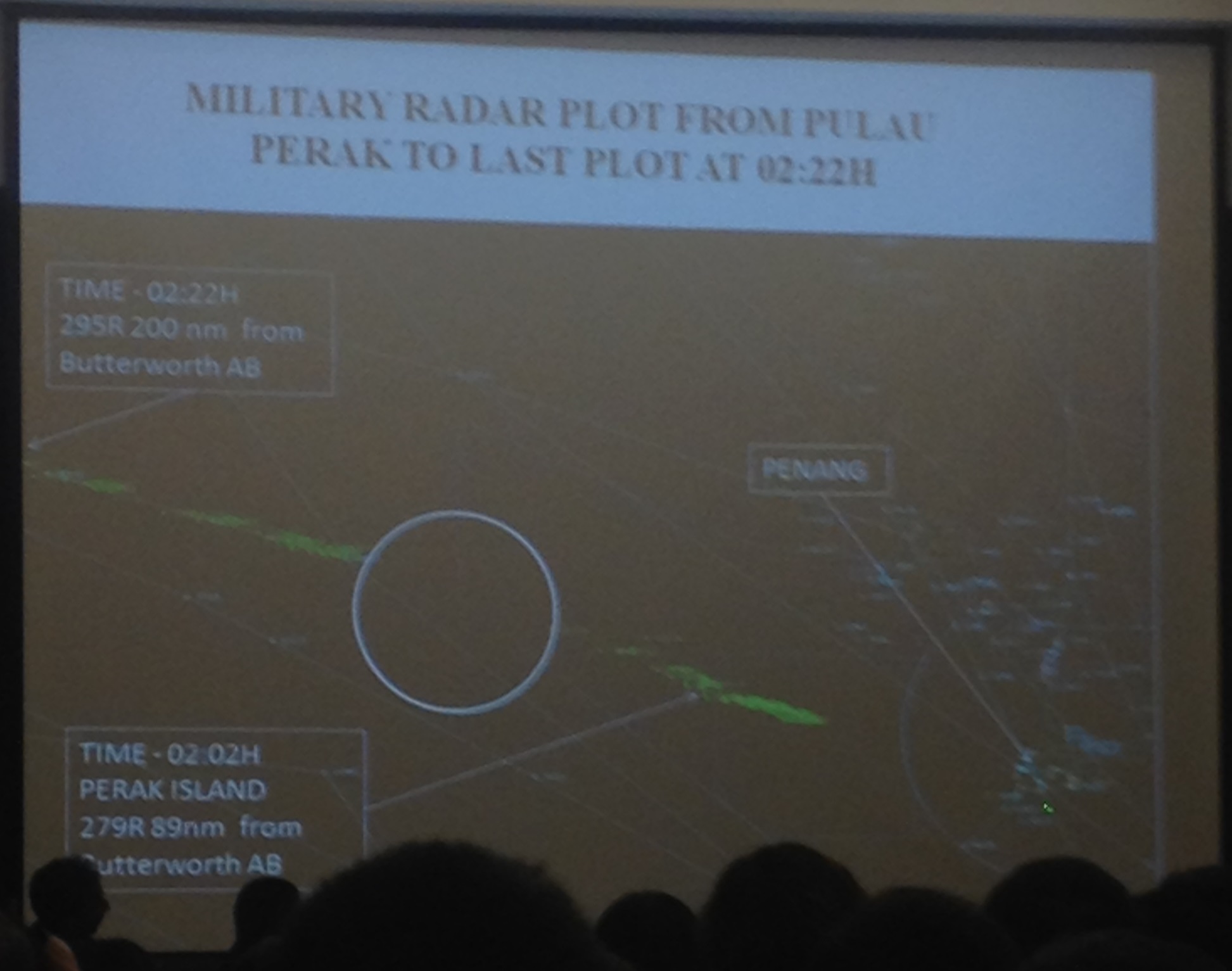
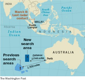
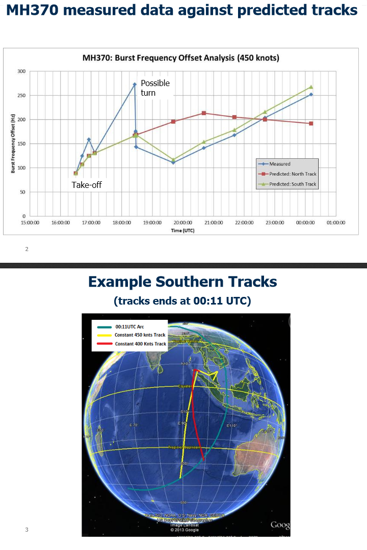